
On the Placencia Sidewalk, the concrete path that runs most of the length of the village, you pass small restaurants and shops until the path simply ends at the sea. Out on the water the reef lies in a long line, and in the west the jungle hides stone temples built by the Maya. Belize packs all of it into a small country where English is the official language, which makes the whole trip easy to follow from the first conversation.
Where is Belize and what is it like?
Belize is a small Central American nation on the Yucatán Peninsula, facing the Caribbean, and it is the only country in Central America without a Pacific coastline. Its capital is Belmopan, set nearer the middle of the country, while Belize City remains the largest city. The population was 397,483 in the 2022 census, so the whole country is smaller than many American cities, and the space between towns is filled with forest, savanna, lagoons and cane fields.
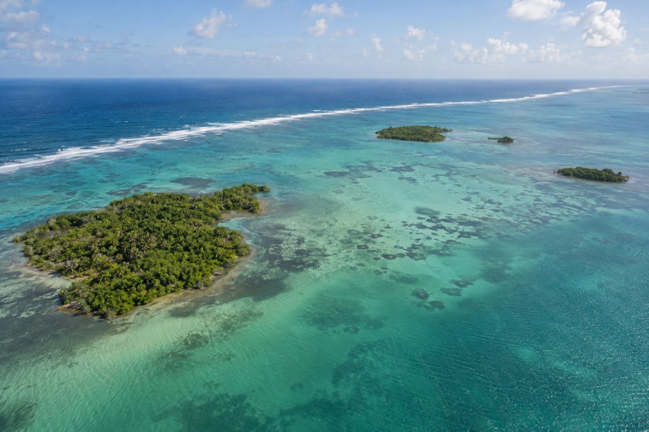
The coast is the headline. The Belize Barrier Reef is the second largest coral reef system in the world and a UNESCO World Heritage Site, and it is the longest in the western hemisphere.
Its islands and atolls, among them Ambergris Caye, Lighthouse Reef, Glover’s Reef and Turneffe, are the reason many travelers come. The Great Blue Hole, a protected natural monument in Belize District, sits on Lighthouse Reef, the most easterly diving area in the country, and Jacques Cousteau made it famous in 1970.
Inland, the country turns green and quiet. Maya cities such as Caracol, Lamanai, Altun Ha, Xunantunich, Cahal Pech and Lubaantun date from a time before 1000 AD when the Maya population here was far denser than it is today. The keel-billed toucan, the national bird, is a common sight on postcards for good reason.
The people are as varied as the landscape. Belizean culture blends Kriol, Maya, East Indian, Garifuna, Mestizo and Mennonite influences. English is the main language in Belize District, Cayo and Toledo, Creole is the main language in Stann Creek, and Spanish dominates in Orange Walk and Corozal near the northern frontier. It suits travelers who want to snorkel in the morning, hear Garifuna drumming at night and walk a jungle temple in between.
Where to go in Belize
Ambergris Caye and San Pedro
San Pedro is the town on the southern part of Ambergris Caye, an island about 25 miles long and only about a mile wide, lying roughly 43 miles off the coast. The island belongs to the Belize District, though the closest mainland point is in Corozal. The reef runs close alongside, so the water is the center of daily life here.
It suits travelers who want a base for reef trips and a long list of restaurants and beach bars within reach of one another. San Pedro received township status on November 27, 1984, and it still has the feel of a small island town rather than a resort enclave.
Caye Caulker
Caye Caulker is a small island about 20 miles north-northeast of Belize City, roughly 5 miles long and one mile west of the Barrier Reef. The village on it, Caye Caulker Village, is home to a few thousand people. The Split, the channel that cuts the island in two, was carved by Hurricane Hattie in 1961, and it is where people gather to sit with a drink and watch the water move.
It suits travelers who like a slow, small-scale island with the reef nearby. Because the reef is so close, snorkeling and boat outings are the natural way to spend the days.
Placencia and the south coast
Placencia is a tourist village and beach base of about 1,600 people at the southern tip of the Placencia Peninsula in the Stann Creek District. Long before Europeans arrived, the Maya lived on this peninsula, producing salt and trading it with other coastal settlements. Today the village is walked along its Sidewalk, a pedestrian-only concrete path lined with businesses that ends at the seashore.
Farther up the coast, Dangriga is the capital of the Stann Creek District, at the mouth of the North Stann Creek River, and Hopkins is a village where about 70 percent of residents were Garifuna at the 2010 census. Together they make the south the place to meet Garifuna culture, with Creole spoken as the main language of the district.
San Ignacio and the Cayo District
San Ignacio sits on the banks of the Macal River in western Belize, about 63 miles west of Belize City and 22 miles west of Belmopan. With neighboring Santa Elena it forms a twin town of just over 21,000 people, and La Loma Luz Hospital in Santa Elena serves both. A bus from San Ignacio to Belmopan takes one hour.
This is the base for the Maya sites and caves of western Belize, including Xunantunich, Cahal Pech and Caracol, and for people who prefer forest and river to sea. English is the major language in the Cayo District.
Belize City and Belmopan
Belize City sits on a small peninsula at the mouth of Haulover Creek, with a population of 63,999 in the 2022 census. It was the capital until a hurricane in 1961 caused flooding and damage, which pushed the government to build Belmopan, 50 miles inland and 249 feet above sea level. Turneffe Atoll lies directly east of Belize City and is the nearest atoll to it. Most people pass through for the airport and the boats, while Belmopan is a small, planned capital worth knowing as the seat of government.
Corozal and the north
Corozal Town lies on the Caribbean Sea about 84 miles north of Belize City and 9 miles from the Mexican border. Spanish is the most used language in Corozal and Orange Walk. Nearby, Cerros on Chetumal Bay was a trade and ceremonial center between about 300 BC and 100 AD, and near Orange Walk the site of Cuello holds some of the oldest pottery found in Mexico and Central America.
Things to do in Belize
Snorkel and dive the reef
The reef is the main reason to come. It stretches roughly 200 miles along the coast, a few hundred feet offshore in the north and about 25 miles out in the south. Ambergris Caye and Caye Caulker put you close to it, while the three atolls, Turneffe, Glover’s Reef and Lighthouse Reef, lie farther out in open water.
Boat trips on the reef are a daily business from the cayes.
Walk among Maya cities
Belize holds several Maya sites, and each has its own character. Caracol carries inscriptions in the Classic Ch’olti’an tongue, the language of the lowland Maya aristocracy. Lamanai, Altun Ha, Xunantunich, Cahal Pech and Lubaantun reflect a civilization far more populous than anyone expects to find in this small country today.
San Ignacio is the natural base for the western sites, while Altun Ha lies in the north of the country and Lubaantun in the south. Each is set in forest, with birdsong as the soundtrack.
Taste Belize and meet its cultures
Food follows the people. Creole kitchens serve rice and beans with stewed chicken, Garifuna cooks in Hopkins and Dangriga make seafood stews with coconut, and Mestizo cooks in the north bring tortillas and recado spice pastes. Mennonite farms supply a good part of the country’s produce and cheese.
Music is part of the same story. Garifuna drumming, in particular, is a living tradition in the south, and the mix of Kriol, Maya, East Indian, Garifuna, Mestizo and Mennonite influences shows up at every market stall and village gathering.
Look for wildlife
Belize law treats all undomesticated mammals, reptiles, birds and amphibians, plus their eggs and nests, as wildlife. In practice that means toucans, including the keel-billed toucan, the national bird, along with many other birds in the forest and wetlands. Sea life along the reef is just as rich, and boat trips are the usual way to see it.
When to visit Belize
The dry season typically runs from February to May, and the rains typically last through November, with a rainy season from June to November. That makes the first months of the year the easiest for reef trips and ruin visits, though January still sees rain on about ten days in Belize City, with highs in the low 80s.
April is the driest of the months sampled, with rain on only about three days in Belize City and highs near 89°F, so expect hot sun on the cayes and in the ruins. July is hot and wetter, with rain on a dozen days in Belize City, and October is the wettest, with more than ten inches of rain in Belize City and rain on nearly fourteen days.
Hurricane season is the other thing to plan around. The Atlantic season runs from June 1 to November 30, and hurricanes that bring coastal flooding, especially in the south of Belize, are prevalent from June to November. A typical Atlantic season brings 14 named storms, 7 hurricanes and 3 major hurricanes. Belize has felt this directly: Hurricane Hattie in 1961 flooded Belize City, split Caye Caulker in two and led to the founding of Belmopan.
So the pattern is simple. Dry months suit the reef and the ruins, the wet months bring greener forest and more cloud, and anyone traveling from June through November should keep the hurricane season in mind when planning the coast.
| Month | Belize City avg high (°F) | Belize City avg low (°F) | Belize City rain (in) | Belize City rain days |
|---|---|---|---|---|
| January | 83.2 | 68.0 | 4.97 | 10.3 |
| April | 88.6 | 74.8 | 1.81 | 3.3 |
| July | 89.3 | 77.0 | 5.73 | 11.8 |
| October | 88.1 | 74.3 | 10.15 | 13.7 |
Getting around Belize
A bus from San Ignacio to Belmopan takes one hour. Belize City is the hub on the coast, Belmopan lies 50 miles inland, and San Ignacio is another 22 miles west of the capital. A bus between Belmopan and San Ignacio takes about one hour, and the road from San Ignacio runs on to Belize City, about 63 miles away.
The cayes are reached across the water. San Pedro on Ambergris Caye lies about 43 miles off the coast, and Caye Caulker sits about 20 miles north-northeast of Belize City. The atolls lie farther out, with Turneffe the nearest to Belize City, directly to its east.
Corozal in the north is about 84 miles from Belize City and 9 miles from the Mexican border, and it is the northern gateway by land. In the south, Placencia sits at the tip of its peninsula in the Stann Creek District, with Dangriga and Hopkins up the coast.
WestJet announced nonstop service from Winnipeg to Belize starting July 27, 2026. Language rarely gets in the way, since English is the official language, used in education, government and most media.
Good to know before you go
The U.S. State Department rates Belize Level 2, “Exercise increased caution”, because of crime, and says the south side of Belize City has historically had the highest concentration of violent crime.
U.S. citizens need a U.S. passport valid for the length of their stay, plus proof of an onward or return ticket and enough funds to cover the whole visit. Tourists staying under 30 days do not need a visa, and Belize requires no special immunizations. Staying longer means getting the passport re-stamped at a local immigration office, and an extension of another 30 days carries a fee of BZ$200.
The Belize dollar is pegged at BZ$2 to US$1, which makes prices easy to convert. Children traveling without both parents need proof of consent and identification from the parent who stays home, along with their birth certificates.
Sources
- Wikipedia, Belize (https://en.wikipedia.org/wiki/Belize), checked October 11, 2026
- Wikivoyage, Belize (https://en.wikivoyage.org/wiki/Belize), checked October 11, 2026
- Wikipedia, Geography of Belize (https://en.wikipedia.org/wiki/Geography_of_Belize), checked October 11, 2026
- Wikipedia, Tourism in Belize (https://en.wikipedia.org/wiki/Tourism_in_Belize), checked October 11, 2026
- Wikipedia, History of Belize (https://en.wikipedia.org/wiki/History_of_Belize), checked October 11, 2026
- Wikipedia, Languages of Belize (https://en.wikipedia.org/wiki/Languages_of_Belize), checked October 11, 2026
- Wikipedia, Ambergris Caye (https://en.wikipedia.org/wiki/Ambergris_Caye), checked October 11, 2026
- Wikipedia, San Pedro Town (https://en.wikipedia.org/wiki/San_Pedro_Town), checked October 11, 2026
- Wikipedia, Caye Caulker (https://en.wikipedia.org/wiki/Caye_Caulker), checked October 11, 2026
- Wikivoyage, Caye Caulker (https://en.wikivoyage.org/wiki/Caye_Caulker), checked October 11, 2026
- Wikipedia, Placencia (https://en.wikipedia.org/wiki/Placencia), checked October 11, 2026
- Wikivoyage, Placencia (https://en.wikivoyage.org/wiki/Placencia), checked October 11, 2026
- Wikipedia, San Ignacio, Belize (https://en.wikipedia.org/wiki/San_Ignacio,_Belize), checked October 11, 2026
- Wikivoyage, San Ignacio (Belize) (https://en.wikivoyage.org/wiki/San_Ignacio_(Belize)), checked October 11, 2026
- Wikipedia, Hopkins, Belize (https://en.wikipedia.org/wiki/Hopkins,_Belize), checked October 11, 2026
- Wikipedia, Dangriga (https://en.wikipedia.org/wiki/Dangriga), checked October 11, 2026
- Wikipedia, Belmopan (https://en.wikipedia.org/wiki/Belmopan), checked October 11, 2026
- Wikivoyage, Belmopan (https://en.wikivoyage.org/wiki/Belmopan), checked October 11, 2026
- Wikipedia, Corozal Town (https://en.wikipedia.org/wiki/Corozal_Town), checked October 11, 2026
- Wikivoyage, Corozal (https://en.wikivoyage.org/wiki/Corozal), checked October 11, 2026
- Wikipedia, Culture of Belize (https://en.wikipedia.org/wiki/Culture_of_Belize), checked October 11, 2026
- Wikipedia, Wildlife of Belize (https://en.wikipedia.org/wiki/Wildlife_of_Belize), checked October 11, 2026
- Belize Tourism Board, Belize tourism (https://www.belizetourismboard.org/belize-tourism/), checked October 11, 2026
- NOAA NCEI, GHCN-Daily station BHM00078583 (Philip S. W. Goldson International Airport, Belize City), normals 1991-2020 computed from the daily record (https://www.ncei.noaa.gov/access/services/data/v1?dataset=daily-summaries&stations=BHM00078583), checked October 11, 2026
- NOAA National Hurricane Center, Climatology (https://www.nhc.noaa.gov/climo/), checked October 11, 2026
- U.S. Department of State, Belize Travel Information, Entry and exit requirements (https://travel.state.gov/), checked October 11, 2026
- Belize Immigration Department, Visitor's permit (https://immigration.gov.bz/permits/visitors-permit/), checked October 11, 2026
- Tropic Air, Belize immigration and visas (https://www.tropicair.com/belize-immigration-visas/), checked October 11, 2026
- Maya Island Air, Belize visa requirements (https://www.mayaislandair.com/belize-visa-requirements/), checked October 11, 2026
- U.S. Department of State, Belize Travel Advisory, Level 2, March 11, 2026 (https://travel.state.gov/), checked October 11, 2026
All our pages
When to go
- Best Time to Visit Belize: Weather by Month, Seasons, Crowds and Festivals
- Belize Weather: Seasons, Rainfall, Sea Temperatures and the Coast Versus the Interior
- Belize in January: Weather, Cayes, Maya Sites and George Price Day
- Belize in February: Weather, Reef Cayes, Maya Ruins and Where to Go
- Belize in March: Weather, Sea Temperatures, Reef Days and the Cayo Highlands
- Belize in April: Warm Seas, Long Light, Placencia and the Cayo
- Belize in May: Weather, Sea Temperatures, Whale Sharks and Where to Go
- Belize in June: Warm Seas, the End of Lobster Season, Rain and Where to Go
- Belize in July: Weather, Sea Temperatures, Regions and What to Do
- Belize in August: Warm Seas, Rain Showers, the Cayes and the Hurricane Season
- Belize in September: Weather, Independence Celebrations and Where to Go
- Belize in October: Weather, Warm Sea, Reef Days and Maya Ruins
- Belize in November: Garifuna Settlement Day, Weather and Where to Go
- Belize in December: Weather, Cayes, Christmas Traditions and Things to Do
- Belize Hurricane Season: Dates, Past Storms and Whether to Travel
- Belize Rainy Season: When It Falls, the Dry Season and How Rain Shifts from North to South
Things to do
- Things to Do in Belize: Maya Ruins, Barrier Reef Diving, Food and Wildlife
- 3 Days in Belize: Caye Caulker, Hol Chan, San Pedro and the Barrier Reef
- 10 Days in Belize: Itinerary Through the Cayes, Cayo and Placencia
- 14 Days in Belize: Itinerary for the Cayes, Cayo, Hopkins and Placencia
- 5 Days in Belize: Itinerary Through Caye Caulker, San Pedro, Hol Chan and Placencia
- 7 Days in Belize: Itinerary with Caye Caulker, San Pedro and San Ignacio
- Altun Ha Belize: The Jade Head, the Temple of the Masonry Altars, Hours and How to Get There
- ATM Cave Belize (Actun Tunichil Muknal): Maya Skeletons, the Jungle Trail, Tickets and Getting There
- Barton Creek Cave Belize: Canoe Tour, Maya History, Hours and Rules
- Belize Barrier Reef: Atolls, the Great Blue Hole, Hol Chan and Marine Reserves
- Belize Facts: Capital, Language, Population and Currency: Belmopan, English, the Belize Dollar and the Reef
- Belize Zoo: Native Wildlife, Jaguars, Tapirs and How to Visit
- Best Beaches in Belize: Ambergris Caye, Placencia, Tobacco Caye and Caye Caulker
- Big Rock Falls Belize: A Mountain Pine Ridge Waterfall, the Hike Out and When to Go
- Birdwatching in Belize: Crooked Tree, Cockscomb Basin, Guanacaste and the Bird Counts
- Cahal Pech Belize: Maya Ruins Above San Ignacio, Hours, Rules and Getting There
- Caracol Belize: Caana Pyramid, Hours and Tickets, Getting There and When to Go
- Cave Tubing in Belize: Nohoch Che'en, the Sibun River, Gear and Rules
- Caves in Belize: Actun Tunichil Muknal, Barton Creek, Nohoch Che'en and St. Herman's
- Caye Chapel Travel Guide: A Private Island, the Reef Next Door and How to Reach It
- Belize Chocolate and Cacao Tours: Toledo District, the May Cacao Festival and Where to Go
- Cockscomb Basin Wildlife Sanctuary: Jaguar Preserve, Trails, Fees and How to Get There
- Community Baboon Sanctuary Belize: Black Howler Monkeys, Riverside Villages and How to Visit
- Crooked Tree Wildlife Sanctuary: Jabiru Storks, Lagoon Birding, Hours and How to Get There
- Belize Culture: Garifuna Music, Maya Sites, Mennonite Villages and National Holidays
- Belize Customs: What You Can Bring: Duties, Cash and Souvenirs
- Belize Departure Tax and Exit Fees: Airport Fees, the PACT Fee and the Chetumal Water Taxi
- Do You Need a Passport for Belize?: Validity, Visa-Free Stays, Extensions and Arrival Paperwork
- Driving in Belize: U.S. License, Right-Side Driving and Road Rules
- Electricity in Belize: Plugs and Voltage, Island Resorts and Charging Your Devices
- Fishing in Belize: Lobster and Conch Seasons, Catch-and-Release Flats and Fishing Rules
- Belizean Food: Rice and Beans, Fry Jacks, Garifuna Dishes and Belikin
- The Fort George area of Belize City, Belize City: Baron Bliss Park, the Tourism Village, Eating and Getting Around
- Gales Point Travel Guide: Manatee Lagoon, Creole Village Life and When to Go
- Garifuna Culture in Belize: Dangriga, Settlement Day, Punta Music and Hopkins
- Whale Sharks in Belize: Gladden Spit, the Silk Cayes and the April and May Season
- Glover's Reef Travel Guide: Atoll Cays, Reef Life and Getting Out There
- Great Blue Hole Belize: Diving the Sinkhole, Lighthouse Reef and Half Moon Caye
- Diving the Great Blue Hole: Lighthouse Reef, Half Moon Caye, Fees and Getting There
- Blue Hole Belize Tour from San Pedro and Caye Caulker: Flight, Dive Boats, Half Moon Caye and What to Know
- Half Moon Caye Natural Monument: Red-Footed Boobies, Turtle Nesting, Diving and Getting There
- Belize Health and Vaccines: Recommended Shots, Water, Medical Care and Insurance
Where to stay
Getting there
- Getting Around Belize: Water Taxis, Small Planes, Airport Transfers and Roads
- Atlanta to Belize: Delta Flights, Where You Land and What You Need for Entry
- Belize International Airport (BZE): Terminals, Arrival, Getting to Your Hotel and Departure
- Cancun to Belize: Flights, the Chetumal Water Taxi and Corozal
- Car Rental in Belize: Licenses, Airport Pickup and Road Conditions
- Charlotte to Belize: Airlines, Landing at Goldson Airport and Entry Requirements
- Chicago to Belize: Connecting Flights, Airlines at Belize City and Entry Requirements
- Dallas to Belize: Airlines, Gateway Cities, the Airport and Entry Papers
- Belize Domestic Flights: Tropic Air, Maya Island Air, Airstrips and Baggage
- Flights to Belize: Airport, Airlines, Departure Day and What to Carry
- Great Blue Hole Flyover: Departures from San Pedro, Caye Caulker and Belize City, Sights and Planning Tips
- Guatemala to Belize by Land: The Melchor de Mencos Crossing, Entry Papers and the Road to San Ignacio
- Houston to Belize: Southwest Flights, the Airport in Ladyville and Entry Rules
- Mexico to Belize by Land: The Chetumal Border, Corozal and What to Bring
- Miami to Belize: Airlines, Where You Land and What You Need for Entry
- Newark to Belize: Connecting Cities, Airlines and Entry Rules
- San Pedro to Caye Caulker: Water Taxi Operators, Route, Luggage and What to Expect
Practical
- Know Before You Go to Belize: Entry Rules, Airport Fees, Money and Health
- Belize vs Costa Rica: Beaches, Wildlife, Weather and Getting Around
- Belize vs Guatemala: Reefs, Maya Ruins, Weather and Getting There
- Belize vs Jamaica: Reef, Rainforest, Reggae and Which Island Fits Your Trip
- Belize vs Mexico: Reefs, Ruins, Weather and Getting There
- Belize vs Roatan: Reefs, Beaches, Getting There and Who Each Suits
- Belize vs the Bahamas: Reefs, Ruins, Weather and Getting There
- Belize on a Budget: Costs, Cheaper Places and Ways to Save
- The cayes vs the Cayo District: Beaches, Maya Ruins, Weather and Getting Around
- Belize Currency: the Belize Dollar, U.S. Dollar Pricing, Cards and ATMs
- Is Belize Safe? Crime, Belize City's South Side, Getting Around and Hurricane Season
- What to Pack for Belize: Medicines, Reef and Jungle Gear, and What to Leave Home
- San Pedro vs Placencia: Beaches, the Reef, Weather and Getting There
Places
- Belize City Travel Guide: Swing Bridge, Museum of Belize, Cayes and Getting Around
- Ambergris Caye and San Pedro Travel Guide: Hol Chan, Shark Ray Alley, Getting There and Where to Stay
- Placencia Travel Guide: The Sidewalk, Whale Sharks, Reef Trips and Where to Stay
- Caye Caulker Travel Guide: Water Taxis, the Reef, Manatee Tours and Island Life
- San Ignacio and the Cayo District Travel Guide: Maya Ruins, Caves, Mountain Pine Ridge and Where to Stay
- Hopkins Travel Guide: Garifuna Culture, Cockscomb Jaguar Preserve and Nearby Cayes
- Corozal Travel Guide: Maya Ruins, Bay Fishing and Life on the Border
- Belmopan Travel Guide: Capital Architecture, St. Herman's Blue Hole and Cayo Day Trips
- Belize Cruises: Ports of Call, Tenders, Harvest Caye and Boarding Documents
- Dangriga Travel Guide: Garifuna Culture, Island Boat Rides and Waterfalls
- Punta Gorda and the Toledo District Travel Guide: Maya Villages, Cacao, Lubaantun and Getting There