
In Belize, a water taxi slows beside a palm-fringed caye while someone at the dock calls out in English, and the reef lies as a pale line of surf beyond the boat. In Mexico, a plaza fills at dusk with the smell of grilled corn and the sound of a brass band tuning up under the laurel trees.
Both countries offer Caribbean water and Maya ruins, but they are very different kinds of trip. The choice comes down to how much ground you want to cover and what you want your days to feel like.
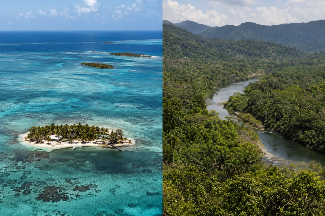
Which is better, Belize or Mexico?
Belize suits travelers who want one compact, English-speaking country built around the reef, the cayes and the rainforest, while Mexico suits those who want range: several coastlines, big cities, deep history and a food scene that changes every few hundred miles. Neither is better in the abstract. They answer different questions, and the table sets the two side by side before the sections that follow take each topic in turn.
| Category | Belize | Mexico |
|---|---|---|
| Beaches | Cayes and a barrier reef running along the coast, with three offshore atolls | Coastlines on the Pacific, the Gulf of California, the Gulf of Mexico and the Caribbean Sea |
| Vibe | Small, unhurried, English-speaking, with Garifuna, Maya, Creole and Mennonite communities | Large and varied, from beach towns to colonial plazas to a capital built on an Aztec city |
| Things to do | Reef and atoll diving and snorkeling, the Great Blue Hole, jungle lodges, Maya sites, wildlife | Maya and Aztec ruins, cenotes, biosphere reserves, markets, museums, resort strips |
| Nightlife | Beach bars and casual evenings on the cayes | Mariachi plazas, mezcal bars and lively resort-town nightlife |
| Weather | Dry season from February to May, rainy season lasting through November | Varies by region, with the Caribbean side following the Atlantic hurricane season |
| Getting there | Flights into Belize City, then onward by road, air or water taxi | Many airports, with Cancún taking direct flights from several continents |
| Best for | Reef, rainforest and a slow pace in one small country | Variety, big-city culture and long road or bus journeys |
A first-time Caribbean traveler who wants snorkeling in the morning and a jungle lodge a little later will find that Belize fits the pattern neatly. Someone who wants to eat their way through street markets, stand in front of a great pyramid and then finish at a beach club will find Mexico has room for all of it. Some travelers use both, and the last sections show how that can work.
Beaches and the sea
Belize is a reef country first and a beach country second. The Belize Barrier Reef is the second-largest coral reef system in the world and a UNESCO World Heritage Site, and it runs along the coast roughly 980 feet offshore in the north and about 25 miles out in the south. Life on the cayes is organized around that reef: boats leave the docks to go out to it, and the sand on the island itself is more of a front yard than a destination.
Beyond the reef lie three atolls, Turneffe Atoll, Glover’s Reef and Lighthouse Reef, and Lighthouse Reef holds the Great Blue Hole, the sinkhole Jacques Cousteau made famous in 1970. On Caye Caulker, the Split, a gap that cuts the island in two, was opened by Hurricane Hattie in 1961, and it has become the spot where the island gathers to sit, talk and watch the light change. San Pedro Town on Ambergris Caye sits off the coast, and getting out there is part of the trip.
Mexico offers a far longer menu. The country has coastlines on the Pacific Ocean, the Gulf of California, the Gulf of Mexico and the Caribbean Sea, so the beach can be a surf break, a calm resort bay, a fishing town with plastic chairs and grilled fish, or a long strip of white sand backed by hotels. The Mesoamerican Barrier Reef, also the second largest coral reef system in the world, lies offshore in the Caribbean east of the Yucatán.
The Yucatán side is where the comparison with Belize is closest, because the same sea and the same reef system lie off both coasts. Mexico’s Caribbean shore has long public beaches and a built-up resort scene, while Belize has smaller islands, fewer buildings and boats as the main way to get to the water. Sea conditions change from day to day on both coasts, so the water you find may differ from the water in the photographs.
Who wins depends on what you want from a beach. For a stay built around the reef, with the sea as the main event and the shore as a place to return to, Belize is the more focused choice.
For range, meaning a choice of oceans, resort towns, fishing villages and big stretches of sand, Mexico offers more variety than a single small country can. Sargassum can reach Caribbean shores in both countries, so it is wise to look at recent photos of a specific beach before you commit.
Things to do
In Belize, the days are shaped by the water and the forest. The reef and the atolls draw divers and snorkelers, and the Great Blue Hole is a protected natural monument and a prime ecotourism destination in Belize District.
Inland, the Cayo District holds jungle lodges and Maya sites such as Xunantunich, Caracol and Cahal Pech, while Lamanai and Altun Ha sit in the north. The Belize Zoo, Crooked Tree and the Cockscomb Basin Wildlife Sanctuary give a look at the wildlife, and the keel-billed toucan, the national bird, is one of the animals visitors hope to spot.
Food in Belize is a mix of Creole, Garifuna, Maya and Mennonite traditions. Rice and beans with stewed chicken is the everyday plate, Garifuna cooks serve hudut, a fish stew in coconut broth with mashed plantain, and Mennonite communities are known for baked goods and farm products.
The evenings are low-key, with beach bars on the cayes and a drink on a dock more common than a club. Wildlife is protected by law in Belize, including eggs, nests and animal parts, which is worth remembering before you pick up a souvenir.
Mexico’s list of things to do is longer, and it is helped by sheer size. The country ranks first in the Americas and seventh in the world by number of UNESCO World Heritage Sites, and the Maya world is only one part of that.
Chichén Itzá, with the Temple of Kukulcán (El Castillo), draws crowds around the equinox, when the shadow of the serpent-god is seen moving down the pyramid at sunset, about March 20 and September 23. Teotihuacan, in Central Mexico, was among the largest cities in the world at its peak.
On the Yucatán Peninsula, which takes in the states of Yucatán, Campeche and Quintana Roo, the Sian Ka’an Biosphere Reserve protects jungles, coral reefs and bird sanctuaries. Cenotes, the limestone sinkholes of the peninsula, are part of almost every itinerary there. Mexico City, founded on the ruins of Tenochtitlan after the Spanish captured it in 1521, adds museums, markets and some of the most varied eating in the Americas, from tacos al pastor to cochinita pibil and mole.
Nightlife is another place where scale matters. Mexican resort towns and cities have dance clubs, mezcal bars, cantinas and plazas where mariachi bands play late. Belize keeps its evenings smaller and quieter. If a trip means ruins in the morning, a market lunch and a lively evening, Mexico has more to offer, and if it means a boat to the reef, a hike into the forest and an early night, Belize fits that pace better.
Weather and the best time to go
In Belize, the dry season typically runs from February to May and the rainy season typically lasts through November. Hurricanes that bring coastal flooding, especially in the south, are prevalent from June to November, and the Atlantic hurricane season runs from June 1 to November 30. A trip in the dry months avoids most of that, while a trip in the wetter months asks for flexibility, because a storm can change plans for the cayes and the coast.
| Month | Belize City average high (°F) | Belize City average low (°F) | Belize City precipitation (inches) | Belize City rain days |
|---|---|---|---|---|
| January | 83.2 | 68.0 | 4.97 | 10.3 |
| July | 89.3 | 77.0 | 5.73 | 11.8 |
Those two months show the shape of the year in Belize City. January is the warm end of the cooler season, with nights that feel mild by Caribbean standards and rain falling on about a third of the days.
July is hotter and stickier, with a higher low at night, and it falls in the stretch when the rainy season is on and the hurricane season is under way. Rain in both months comes on enough days that a rain jacket belongs in the bag.
Mexico does not have one climate, and that is the main difference. The Caribbean coast of the Yucatán follows the same Atlantic hurricane season as Belize, while the Pacific coast has its own season, which starts in mid-May. Mexico City, Oaxaca and the highlands are another world, and the ruins of the Yucatán, the beaches of the Pacific and the colonial cities of the center each have their own best moment.
If the plan is a reef trip in Belize, the dry months from February to May make the most sense on paper. If the plan is Mexico, the calendar depends on the region, and a single trip can span very different weather. Outside the official hurricane season, from December to May, the Caribbean side of both countries is out of that window, and it is the stretch many people choose for beach time on either coast.
Getting there and getting around
Flying into Belize means landing at the Philip S. W. Goldson International Airport near Belize City, and from there the cayes, the coast and the interior all lie ahead.
Turneffe Atoll lies directly east of Belize City and is the nearest of the atolls to it, and San Pedro Town on Ambergris Caye lies out to sea, so a trip to the cayes means leaving the mainland by boat. The country is small, and that shapes the experience: the main sights are close enough to be combined in one trip.
Mexico has airports all over the country, and the Yucatán alone has several gateways. Cancún International Airport receives direct international flights from Canada, Cuba, Europe, Central America, the United States and South America. Mérida International Airport and Cozumel International Airport have direct international flights only from the United States and Canada. Which one you choose changes the whole trip, because Cancún opens the Caribbean coast, Mérida the colonial and Maya interior and Cozumel the island.
Once in Mexico, buses are a common way to cover ground. ADO, Autobuses Del Oriente, serves Chiapas, Tabasco, Yucatán, Quintana Roo and Campeche, with connections from Mexico City and neighboring states, and the ADO app lets you buy and store tickets and show the QR code to the driver instead of buying in person. That makes a loop through the peninsula, from the coast to the ruins to a colonial city, possible without a car.
The two countries meet on the water at Chetumal, the capital of Quintana Roo, on Chetumal Bay near the mouth of the Río Hondo. San Pedro Belize Express Water Taxi departs there from the Terminal Maritima Internacional Filiberto Sabido Padilla, and the trip from San Pedro on Ambergris Caye takes 1 hour 30 minutes.
From Chetumal the water taxi serves Belize City, Caye Caulker and San Pedro. Getting around the cayes and the Belizean interior beyond that depends on the place you choose, and each destination has its own way in.
Who should choose which
Pick Belize if you want a trip built around the reef and the forest in a country that is easy to hold in your head. English is the official language, the only one of any mainland Central American country, and the population was 397,483 in the 2022 census, so the scale is small. It suits divers and snorkelers, birders, travelers who like a slow evening and anyone who wants Garifuna, Creole, Maya and Mennonite cultures in one small place.
Pick Mexico if you want variety, from the Pacific to the Gulf to the Caribbean, from ruins to cities to beaches. It suits people who travel for food and markets, history buffs, road-trippers and bus travelers, and anyone who wants to build a long trip with several different stops. The scale also means choosing a region, because Mexico is too big to see in one visit.
Combining the two works best around the Yucatán and Belize’s coast. A trip can begin at Cancún, move south along the Mexican Caribbean to Chetumal, take in nearby Bacalar, a Maya city founded as Sian Ka’an Bakhalal that later became a Spanish town, and then cross by water taxi to Belize City, Caye Caulker or San Pedro. That gives you Mexico’s ruins and food and Belize’s reef and cayes in one journey, ending on the water instead of on a highway.
Good to know before you go
The U.S. State Department rates Belize Level 2, “Exercise increased caution”, because of crime, and says the south side of Belize City has historically had the highest concentration of violent crime.
Belize uses the Belize dollar, and it is worth knowing which currency a price is quoted in before you pay. The Atlantic hurricane season runs from June 1 to November 30 and affects both the Belizean coast and Mexico’s Caribbean shore.
In Mexico, conditions can vary widely from state to state and even within a state, and emergency services are limited or unavailable in remote or rural areas, so it helps to plan a route with that in mind. In both countries, ask locally about the area you are visiting before you set out.
Sources
- Wikipedia, Belize (https://en.wikipedia.org/wiki/Belize), checked October 11, 2026
- Wikivoyage, Belize (https://en.wikivoyage.org/wiki/Belize), checked October 11, 2026
- Wikipedia, Tourism in Belize (https://en.wikipedia.org/wiki/Tourism_in_Belize), checked October 11, 2026
- Wikipedia, Wildlife of Belize (https://en.wikipedia.org/wiki/Wildlife_of_Belize), checked October 11, 2026
- U.S. Department of State, Belize Travel Information, Travel Advisory (Level 2) (https://travel.state.gov/), checked October 11, 2026
- U.S. Department of State, Belize Travel Information, Entry and exit requirements (https://travel.state.gov/), checked October 11, 2026
- Wikipedia, Mexico (https://en.wikipedia.org/wiki/Mexico), checked October 11, 2026
- Wikivoyage, Yucatan Peninsula (Mexico) (https://en.wikivoyage.org/wiki/Yucat%C3%A1n_Peninsula), checked October 11, 2026
- U.S. Department of State, Mexico Travel Advisory (https://travel.state.gov/), checked October 11, 2026
- U.S. Department of State, Mexico Travel Information, Entry and exit requirements (https://travel.state.gov/), checked October 11, 2026
- Wikipedia, Chetumal (https://en.wikipedia.org/wiki/Chetumal), checked October 11, 2026
- Wikipedia, Bacalar (https://en.wikipedia.org/wiki/Bacalar), checked October 11, 2026
- San Pedro Belize Express Water Taxi, Chetumal (https://belizewatertaxi.com/destinations/chetumal/), checked October 11, 2026
- NOAA NCEI, GHCN-Daily station BHM00078583 (Philip S. W. Goldson International Airport, Belize City), normals 1991-2020 computed from the daily record (https://www.ncei.noaa.gov/access/services/data/v1?dataset=daily-summaries&stations=BHM00078583), checked October 11, 2026
- U.S. Department of State, Belize Travel Advisory, Level 2, March 11, 2026 (https://travel.state.gov/), checked October 11, 2026
- NOAA National Hurricane Center, Climatology (https://www.nhc.noaa.gov/climo/), checked October 11, 2026