
Early in the day, the Macal River runs brown and slow under the narrow suspension bridge that joins San Ignacio to Santa Elena, and the town starts up with the smell of fry jacks and strong coffee. Beyond the last houses, the road climbs into hills of pine, cattle pasture and rainforest, where Maya pyramids stand in the trees. San Ignacio is the hub of Belize’s western interior, a river town for travelers who come for ruins, caves and green country instead of the reef.
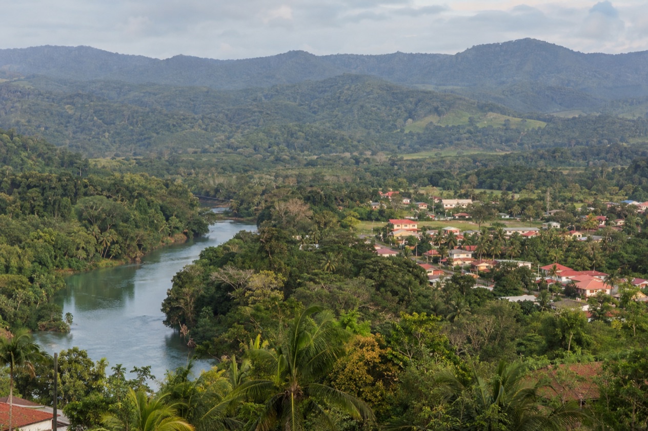
Where is San Ignacio and the Cayo District and what is it like?
San Ignacio sits on the banks of the Macal River in western Belize, about 63 miles west of Belize City and 22 miles west of the capital, Belmopan, and it is the capital of the Cayo District. Cayo is the western district of the country.
It borders Guatemala to the west, Orange Walk to the north, Belize District to the northeast, Stann Creek to the southeast and Toledo to the south. There is no coastline here. The landscape is river valley, limestone hills, farmland and forest.
The town itself is half of a pair. San Ignacio and its sister town Santa Elena face each other across the Macal and are linked by the Hawkesworth Bridge, Belize’s only suspension bridge, a one-lane span built in 1949.
Together they form the third largest urban area in the country, with a population just over twenty-one thousand at the last census. Santa Elena also holds La Loma Luz Hospital, the main hospital of the twin towns.
The mix of people shapes the feel of the place. In the last census, Hispanic and Mestizo residents made up the largest share of the district, followed by Creole, Maya and Mennonite communities. You hear Spanish and English in the same conversation, and Kriol in the next. Menus lean on rice and beans, stew chicken, tamales and fresh tortillas, and the border with Guatemala is close enough that its influence reaches the plate.
The pace is that of a base camp. People leave early for a ruin or a cave, come back muddy or sun-warmed, and spend the evening on a porch or in a restaurant near the center.
It suits travelers who like rivers, birds, trails and archaeology. If your idea of a vacation is a beach chair and a drink with a view of the reef, you will find the water here is the river, not the sea.
What is there to do in San Ignacio and the Cayo District?
Cayo’s calling card is the combination of Maya ruins, caves and forest within one district. Neighbors on the coast offer reef and cayes, and the north offers lagoons and river wildlife. Here the draw is what lies in the hills and under them.
Maya sites around town
Cahal Pech overlooks San Ignacio from a hilltop and is only a ten-minute walk from the town center. The name means The Place of Ticks, and its interconnected courtyards and temples show how Maya architecture evolved over the centuries.
The site has evidence of habitation going back to 1200 BCE, which makes it one of the oldest recognizably Maya sites in western Belize. The hilltop looks out over the meeting of the Macal and Mopan rivers.
Xunantunich, whose name means Maiden of the Rock, stands on a ridge above the Mopan River, very close to the Guatemala border. Reaching it means crossing the river on a hand-cranked ferry near the village of San Jose Succotz. El Castillo, the main pyramid, rises 130 feet and is the second tallest structure in Belize. Around it are six plazas surrounded by more than twenty-six temples and palaces.
Caracol lies deep in the forest to the south and is the largest of them all. Its great building, Caana, is the tallest man-made structure in Belize at 141 feet, and the area became a national park in 1991. The site museum opened in 1999.
| Site | Open |
|---|---|
| Xunantunich | Every day, 8:00 am to 5:00 pm, including Sundays and public and bank holidays (last tour for drivers one hour before closing) |
| Cahal Pech (April through October) | Every day, 6:00 am to 6:00 pm, including Sundays and public and bank holidays |
Caves of the Cayo hills
Actun Tunichil Muknal, known as ATM, is a cave in the Tapir Mountain Nature Reserve and an archaeological site where skeletons, ceramics and stoneware remain from the ancient Maya. Fourteen skeletal remains have been found in the upper passage, along with many pieces of pottery. The cave’s Monkey Pot is one of only four of its type found in Central America. The main system runs about three miles, including a long river passage.
Barton Creek Cave is the other name you will hear. It lies in the upper Barton Creek area near San Ignacio and draws adventure travelers interested in cave canoeing. The Maya used it too, and the remains of at least twenty-eight people have been found inside, with evidence of ritual use on ten ledges within the first kilometer of passage. Both caves are places where the story is as striking as the scenery.
Mountain Pine Ridge and the rivers
Mountain Pine Ridge Forest Reserve changes the look of Belize. Established in 1944 to protect the native pine forests, it covers a little over a hundred thousand acres of higher ground, with elevations averaging between 400 and 700 meters and a high point at Baldy Beacon. The Macal River marks its western and southern edges. Pines replace broadleaf jungle, and the air feels different under them.
The park roads are unpaved and not served by any real bus service, so this is country you reach on your own wheels or on an organized outing. The Macal and Mopan rivers are the other great lines through the district, and both run past ruins, lodges and farms. Lodges such as Chaa Creek, Blancaneaux Lodge and Ka’ana are located in the Cayo District.
Mennonite country and the border towns
Cayo has a second cultural thread in its Mennonite settlements. Spanish Lookout is a Mennonite community that has modernized to a large degree, while the Noah Hoover Mennonites of Upper Barton Creek and the settlements that grew from it use horse-drawn buggies. You may share a road with one. Their farms are part of why the district’s landscape looks so cultivated.
To the west, Benque Viejo del Carmen is the westernmost town in Belize, right on the Guatemalan border across from Melchor de Mencos, and the Mopan River runs along its edges. Xunantunich is nearby. Each weekday morning, students from the Guatemalan side walk across the pedestrian crossing to board school buses into Belize, a small sign of how closely the two towns are tied.
How many days do you need in San Ignacio and the Cayo District?
A long weekend is enough to taste Cayo, and a week lets you work through it properly. With a few days you can pair a morning at a nearby ruin with an evening in town, and add one cave. The district rewards slowness, because many of the best things are an hour or more from the center and are best taken one at a time.
A short stay might start with Cahal Pech, since it sits on the edge of town and you can walk to it. Xunantunich and its river ferry make a natural second visit, and the cave of your choice, ATM or Barton Creek, fills the other slot. Between them, leave time for the river, for a meal in San Ignacio and for crossing the Hawkesworth Bridge on foot to see Santa Elena.
With more time, Caracol deserves its own day and its own mood. The road to it is paved for the last 9.9 miles, and it joins the Western Highway between San Ignacio and Belmopan and also runs to Santa Elena.
Mountain Pine Ridge is the other outing that shapes a day around it, with its pine forest, high ground and rivers. A longer visit also makes room for the smaller sites such as El Pilar, Baking Pot and Lower Dover.
Beyond a week, the district opens toward its edges. You can spend an evening in Benque Viejo del Carmen, look into the Mennonite communities, or use San Ignacio as the first stop of a trip that then moves toward the coast. Hopkins is reached by a bus via Belmopan that takes three hours, which makes the combination of river valley and sea workable.
Where to stay in San Ignacio and the Cayo District
Staying in town puts Cahal Pech a ten-minute walk away and puts you at the starting point of most outings. Santa Elena, across the bridge, is the quieter twin and holds the hospital. The two towns together are the district’s urban center.
Out of town, Cayo has a different kind of stay: the lodge. That suits travelers who want the forest outside the door. Mountain Pine Ridge, with its unpaved park roads and no real bus service, is a setting where being on site matters more.
Toward the border, Benque Viejo del Carmen is a small town with Xunantunich nearby and the Guatemalan crossing at the end of the road. Upper Barton Creek, where the Noah Hoover Mennonites live, puts you near Barton Creek Cave among farms and buggies. Pick the area by what you want near the door: the evening street life of San Ignacio, a lodge in the forest, or a quiet corner close to a particular site.
How do you get to San Ignacio and the Cayo District and get around?
San Ignacio is reached by road, about 63 miles west of Belize City and 22 miles west of Belmopan. From Belmopan, a bus takes one hour. Hopkins connects by bus via Belmopan in three hours. The Western Highway runs between San Ignacio and Belmopan, and it is the road that the way to Caracol joins.
Inside town, the center is built for walking. Cahal Pech is a ten-minute walk, and the Hawkesworth Bridge is a pedestrian pleasure as much as a road link, though cars use its single lane in turns. The bridge connects San Ignacio and Santa Elena over the Macal River, and it is the physical spine of the twin towns.
Further out, the details change by destination. Caracol lies at the end of a road paved for its last 9.9 miles. The park roads in Mountain Pine Ridge are unpaved and not served by any real bus service.
To the west, Benque Viejo del Carmen lies 8.1 miles from San Ignacio and 31 miles from Belmopan, on the Guatemalan border. Melchor de Mencos, across it, is the only major border crossing from Guatemala to Belize, and its pedestrian crossing is used each weekday morning by students heading to Belize. Whatever your route, the roads here connect a small number of towns, and the map is simple to read.
When is the best time to visit San Ignacio and the Cayo District?
February through May is the dry season in the Mountain Pine Ridge reserve, and those months are the clearest choice for trails, rivers and ruins. The rainy season there runs from July to February, so the shift from wet to dry comes in February. The dry months are also the hottest, and temperatures in the reserve may reach 102°F.
For a sense of the year’s range, Belize City’s January days average a high of 83.2°F with just over ten days of rain. In July, the same city’s highs average 89.3°F with almost twelve rain days. The Cayo hills have their own conditions, but the pattern of a cooler start to the year and a hotter, wetter midsummer gives you the outline.
The Atlantic hurricane season runs from June 1 to November 30, so the wet months of the year overlap with it, and a trip between those dates falls in the official season. Ruins and caves are part of the district all year, and each month changes the light, the river and the green of the hills. If you want the driest months for the ruins, aim for the spring, and if you want the green, rain-fed landscape, the second half of the year delivers it.
Good to know before you go
The U.S. State Department rates Belize Level 2, “Exercise increased caution”, because of crime, and says the south side of Belize City has historically had the highest concentration of violent crime.
The Belize dollar is the local currency, and prices at the sites are set by the authorities that run them.
The hospital in Santa Elena is the main one for the twin towns. The district falls within the Atlantic hurricane season, so keep an eye on forecasts if your dates fall in the season.
Sources
- Wikipedia, San Ignacio, Belize (https://en.wikipedia.org/wiki/San_Ignacio,_Belize), checked October 11, 2026
- Wikivoyage, San Ignacio (Belize) (https://en.wikivoyage.org/wiki/San_Ignacio_(Belize)), checked October 11, 2026
- Wikipedia, Cayo District (https://en.wikipedia.org/wiki/Cayo_District), checked October 11, 2026
- Wikipedia, Xunantunich (https://en.wikipedia.org/wiki/Xunantunich), checked October 11, 2026
- Wikipedia, Cahal Pech (https://en.wikipedia.org/wiki/Cahal_Pech), checked October 11, 2026
- Wikipedia, Caracol (https://en.wikipedia.org/wiki/Caracol), checked October 11, 2026
- Wikipedia, Mountain Pine Ridge Forest Reserve (https://en.wikipedia.org/wiki/Mountain_Pine_Ridge_Forest_Reserve), checked October 11, 2026
- Wikivoyage, Mountain Pine Ridge (https://en.wikivoyage.org/wiki/Mountain_Pine_Ridge), checked October 11, 2026
- Wikipedia, Actun Tunichil Muknal (https://en.wikipedia.org/wiki/Actun_Tunichil_Muknal), checked October 11, 2026
- Wikipedia, Barton Creek Cave (https://en.wikipedia.org/wiki/Barton_Creek_Cave), checked October 11, 2026
- NICH ticketing, Xunantunich (https://ticketing.nichbelize.org/product/xunantunich/), checked October 11, 2026
- NICH ticketing, Cahal Pech (https://ticketing.nichbelize.org/product/cahal-pech/), checked October 11, 2026
- Wikipedia, Benque Viejo del Carmen (https://en.wikipedia.org/wiki/Benque_Viejo_del_Carmen), checked October 11, 2026
- Wikipedia, Melchor de Mencos (https://en.wikipedia.org/wiki/Melchor_de_Mencos), checked October 11, 2026
- Wikipedia, Mennonites in Belize (https://en.wikipedia.org/wiki/Mennonites_in_Belize), checked October 11, 2026
- Wikipedia, Climate of Belize (https://en.wikipedia.org/wiki/Climate_of_Belize), checked October 11, 2026
- NOAA NCEI, GHCN-Daily station BHM00078583 (Philip S. W. Goldson International Airport, Belize City), normals 1991-2020 computed from the daily record (https://www.ncei.noaa.gov/access/services/data/v1?dataset=daily-summaries&stations=BHM00078583), checked October 11, 2026
- U.S. Department of State, Belize Travel Advisory, Level 2, March 11, 2026 (https://travel.state.gov/), checked October 11, 2026
- NOAA National Hurricane Center, Climatology (https://www.nhc.noaa.gov/climo/), checked October 11, 2026
All our pages
When to go
- Best Time to Visit San Ignacio and the Cayo District: Weather, Maya Sites and Seasons
- San Ignacio and the Cayo District in January: Weather, Maya Sites and George Price Day
- San Ignacio and the Cayo District in February: Weather, Maya Sites, Caves and a Two-Day Plan
- San Ignacio and the Cayo District in March: Weather, Maya Sites, Baron Bliss Day and a Two-Day Plan
- San Ignacio and the Cayo District in April: Weather, Maya Sites, River Days and Two-Day Plan
- San Ignacio and the Cayo District in May: Weather, Maya Sites, Barton Creek Cave and a Two-Day Plan
- San Ignacio and the Cayo District in June: Weather, Maya Ruins, Rivers and a Two-Day Plan
- San Ignacio and the Cayo District in July: Green Season, Maya Sites and Cave Country
- San Ignacio and the Cayo District in August: Weather, Maya Sites, River Days and a Two-Day Plan
- San Ignacio and the Cayo District in September: Weather, Maya Sites, Independence Month and a Two-Day Plan
- San Ignacio and the Cayo District in October: Weather, Maya Sites, Caves and a Two-Day Plan
- San Ignacio and the Cayo District in November: Garifuna Settlement Day, Maya Ruins and River Days
- San Ignacio and the Cayo District in December: Weather, Maya Sites, Caves and a Two-Day Plan
Things to do
- Things to Do in San Ignacio and the Cayo District: Maya Ruins, Caves, Rivers and Local Food
- Day Trips from San Ignacio and the Cayo District: Xunantunich, Caracol, Caves and Mountain Pine Ridge
- 3 Days in San Ignacio and the Cayo District: Cahal Pech, Xunantunich, Caracol and the Macal River