
Rain drums on the boardwalk of Creek Street, salmon gather below the footbridges, and a floatplane lifts off the Tongass Narrows with a low drone. It suits travelers who like totem poles, history and wild country at the edge of town, and who do not mind getting wet.
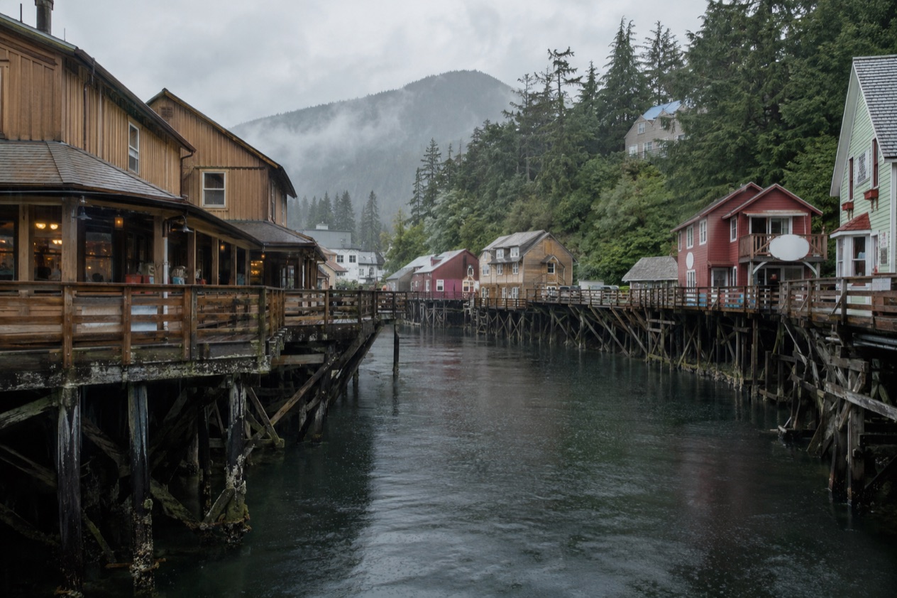
Where is Ketchikan and what is it like?
Ketchikan sits on Revillagigedo Island in southernmost Southeast Alaska, in the Inside Passage, about 700 miles northwest of Seattle. The town stretches along the Tongass Narrows at the foot of Deer Mountain, with rainforest climbing right up behind the houses. It is home to roughly 14,000 people, and it is the southernmost of Alaska’s larger cities and one of the three largest in the region, alongside Juneau and Sitka.
The setting shapes everything. Water is on one side, forest on the other, and the town squeezes into the strip between them. Ketchikan is nicknamed the Rain Capital of Alaska, and locals treat wet weather as part of the scenery rather than a problem. A waterproof jacket is simply what people wear here, and the green of the forest and the shine on the streets are a big part of the charm.
The character is a blend of layers. Ketchikan began as a seasonal Tlingit fish camp before becoming a border town that has welcomed pioneers since the late 1800s, a mix of people who came to find their fortunes, start over or simply misbehave. Today the Tlingit, Haida and Tsimshian cultures are all part of the town’s life, and you see that most clearly in the totem poles scattered through the neighborhoods and parks.
The pace is set by the water and by the cruise calendar. When ships are in, the downtown waterfront fills with people and the shops and galleries hum.
When they leave, the town returns to fishing boats, ferry schedules and neighbors chatting on the dock. Visitors who love history, Native art and misty scenery tend to fall for it. Those who want big-city nightlife, sunshine or a beach will find a quieter, damper place than they imagined.
What is there to do in Ketchikan?
Ketchikan is different from its Southeast Alaska neighbors because it combines a large standing-totem collection with a creek-side boardwalk of old buildings and easy access to Misty Fjords and the Tongass National Forest.
Totem poles and Native culture
Ketchikan is known for one of the largest collections of standing totem poles in the world. You see them around town, in the totem parks and at the Totem Heritage Center. The collection spreads across Saxman Totem Park, Totem Bight State Historical Park, Potlatch Park and the Heritage Center, so you can build a day around them.
Totem Bight State Historical Park sits on the site of a traditional Native campground once called Mud Bight Village. Here a path leads through the trees to a collection of poles and a replica of a traditional chieftain’s house, with the water close by.
Saxman, a Tlingit community next to town, is another stop for poles and for the story of the people who live there. The Totem Heritage Center is the place to look at poles up close and learn about the cultures behind them.
| Site | Where |
|---|---|
| Totem Bight State Historical Park | Mile 10.5 of the North Tongass Highway |
| Saxman Totem Park | Saxman, next to Ketchikan |
| Totem Heritage Center | Ketchikan |
Creek Street and downtown
Downtown Ketchikan is easy to walk, with historic buildings, galleries, shops and locally made goods. The most photographed corner is Creek Street, a row of buildings along Ketchikan Creek. It was once a raucous red-light district that served miners, fishermen and loggers, and during Prohibition a row of speakeasies. Today quieter establishments fill the old buildings, but the historic charm remains.
The Tongass Historical Museum tells the story of the town’s people, businesses and events from the late 19th and early 20th centuries. It helps explain how fishing, canneries and logging built the place, and why Ketchikan became known as the Canned Salmon Capital of the World. Between May and September the Great Alaskan Lumberjack Show is performed near Ketchikan Creek, a lively break from the museums.
Misty Fjords and the Tongass
Misty Fjords National Monument lies about 40 miles east of Ketchikan along the Inside Passage coast. It is part of the Tongass National Forest and covers more than two million acres, nearly all of it designated wilderness. From Ketchikan, visitors can take a floatplane to Misty Fjords, which turns a rainy-day town into a gateway to sheer rock walls and deep water.
The Tongass is the largest national forest in the country, and Ketchikan is where the Forest Service has its headquarters offices. The Southeast Alaska Discovery Center in town offers Forest Service visitor programs, a good first stop if you want to understand the rainforest around you before you head into it.
How many days do you need in Ketchikan?
A long weekend is enough to see the essentials, and a few more days let you add a flight or boat trip into the wilderness. The town is compact, so the main sights fit together without much rushing.
With a short stay, spend one day on the town itself. Walk Creek Street, step into the Tongass Historical Museum and browse the galleries and shops for locally made goods. Add the Totem Heritage Center and one of the totem parks, either Totem Bight to the north or Saxman next door. In season, the Lumberjack Show makes an easy evening or afternoon break.
A second and third day open up the surroundings. A floatplane to Misty Fjords is the headline excursion, and it is worth keeping a flexible day for it because flying depends on the weather. The Southeast Alaska Discovery Center and the Tongass National Forest give you a rainforest day on foot if the sky cooperates, and if it does not, you will still be properly in the setting.
With more time, think about places across the water. Metlakatla, on Annette Island about 16 miles south of Ketchikan, is usually reached by Alaska Marine Highway ferry, or by boat or seaplane across the Revillagigedo Channel. Prince of Wales Island, with its Tongass forest, wilderness areas and the community of Craig, is another option for travelers who want even quieter country. Hollis, on the island, has a ferry terminal.
Where to stay in Ketchikan
Downtown is the natural base for visitors. Staying here suits travelers who want to step out of the door and into the story of the town, without arranging transportation for every meal or stroll.
Downtown can be lively on days when ships are in, since the town hosts more than 800,000 cruise visitors a year. Anyone who prefers a quieter setting can look along the Tongass Narrows away from the center, where the road follows the water and the forest presses close. The North Tongass Highway leads toward Totem Bight, so a base in that direction puts the totem park nearer your door.
Saxman lies just southeast of the city, and it is a separate community with its own character, best treated as a place to visit rather than a place to sleep. For visitors who want a stay built around wilderness, lodges and remote outposts in the Misty Fjords area and on islands around Ketchikan are another style of trip altogether, one that trades the convenience of town for the forest and water.
How do you get to Ketchikan and get around?
Ketchikan is on an island, so you arrive by air, by sea or by ferry. Ketchikan International Airport opened in 1973 and has an asphalt runway for regular aircraft plus a water runway for seaplanes, which tells you how much flying matters here. Travelers, though, arrive by cruise ship, since ships ply the Inside Passage and visit Ketchikan from early May through late September.
Cruise ships dock in one of two main places. Downtown has five potential docking locations: Piers 1 through 4, and Doyon Landing, which typically accommodates smaller overnight ships. The other is Ward Cove, approximately 5.5 miles from downtown, with a single pier that allows docking on both sides. The Cruise Ship Calendar on the Visit Ketchikan website shows where your ship will dock.
Getting around the center is mostly a matter of walking. Downtown is easy to walk, and the main sights cluster along the waterfront and the creek. For outings, tours may be booked on the day of your visit at the Visitors Center on Berth 2 or at any of the kiosks located on the docks. Floatplanes carry visitors to Misty Fjords, and the Alaska Marine Highway ferry connects Ketchikan with Metlakatla.
Farther sights such as Totem Bight, at Mile 10.5 of the North Tongass Highway, and Saxman lie along the roads outside the center. Maps of Ketchikan, including a Downtown Ketchikan map and a Revillagigedo Island map, are available from the visitors bureau, along with a free visitors guide.
When is the best time to visit Ketchikan?
The best months are the cruise-season months from May through September, when the Lumberjack Show runs, the town is fully open and the waterfront is at its liveliest. July is a good example: highs in the mid-60s, lows in the low 50s, and about ten days with measurable precipitation, which in Ketchikan counts as a comparatively kind month.
Rain is part of the deal at any time, and the town earns its Rain Capital of Alaska nickname. January is far wetter, with more than sixteen inches of precipitation and measurable precipitation on most days, and highs near 40. A winter visit means a quiet, gray, damp Ketchikan, with the cruise crowds gone and the town to the locals.
The busiest weeks are the ones when ships are in, from early May through late September, with the waterfront at its most crowded on those days. If you prefer a calmer pace, use the Cruise Ship Calendar to see which days are lighter. Either way, plan on rain gear, and treat the weather as part of what you came for.
| Month | Average high (°F) | Average low (°F) | Precipitation (inches) | Days with precipitation |
|---|---|---|---|---|
| January | 39.7 | 31.5 | 16.17 | 17.1 |
| July | 64.5 | 53.2 | 7.33 | 10.8 |
Good to know before you go
Ketchikan is a working town as well as a destination, so bring layers and a rain jacket whatever the month. Cruise service runs from early May through late September, and the Lumberjack Show is a May to September attraction, so a winter visit has fewer organized options. For cruise days, tours can be booked on the spot at the Visitors Center on Berth 2 or the dock kiosks, and the Visit Ketchikan website has the calendar and a free visitors guide.
Sources
- Visit Ketchikan (https://www.visit-ketchikan.com/), checked October 11, 2026
- Wikivoyage, Ketchikan (https://en.wikivoyage.org/wiki/Ketchikan), checked October 11, 2026
- Wikipedia, Ketchikan, Alaska (https://en.wikipedia.org/wiki/Ketchikan,_Alaska), checked October 11, 2026
- Wikipedia, Ketchikan International Airport (https://en.wikipedia.org/wiki/Ketchikan_International_Airport), checked October 11, 2026
- Wikipedia, Misty Fjords National Monument (https://en.wikipedia.org/wiki/Misty_Fjords_National_Monument), checked October 11, 2026
- Wikipedia, Saxman, Alaska (https://en.wikipedia.org/wiki/Saxman,_Alaska), checked October 11, 2026
- Wikipedia, Totem Bight State Historical Park (https://en.wikipedia.org/wiki/Totem_Bight_State_Historical_Park), checked October 11, 2026
- Wikipedia, Prince of Wales Island (Alaska) (https://en.wikipedia.org/wiki/Prince_of_Wales_Island_(Alaska)), checked October 11, 2026
- Wikipedia, Metlakatla, Alaska (https://en.wikipedia.org/wiki/Metlakatla,_Alaska), checked October 11, 2026
- Wikipedia, Tongass National Forest (https://en.wikipedia.org/wiki/Tongass_National_Forest), checked October 11, 2026
- Wikipedia, Southeast Alaska (https://en.wikipedia.org/wiki/Southeast_Alaska), checked October 11, 2026
- Wikipedia, Climate of Alaska (https://en.wikipedia.org/wiki/Climate_of_Alaska), checked October 11, 2026
- NOAA NCEI, U.S. Climate Normals 1991-2020, monthly (https://www.ncei.noaa.gov/access/services/data/v1?dataset=normals-monthly-1991-2020&stations=USW00025325), station Ketchikan Intl Ap, elevation 76 feet, checked October 11, 2026
All our pages
When to go
- Best Time to Visit Ketchikan: Weather by Month, Long Summer Days, Totem Parks and Quiet Seasons
- Ketchikan in January: Rainy Streets, Short Days and a Quiet Waterfront
- Ketchikan in February: Rain, Totem Poles and Quiet Winter Streets
- Ketchikan in March: Weather, Totem Poles and Things to Do
- Ketchikan in April: Weather, Daylight, Downtown Walks and a Two-Day Plan
- Ketchikan in May: Totem Poles, Rain Gear, Long Light and Misty Fjords
- Ketchikan in June: Weather, Totem Poles and What to Do
- Ketchikan in July: Weather, Long Days, Totems and a Two-Day Plan
- Ketchikan in August: Weather, Totem Poles, Misty Fjords and What to Do
- Ketchikan in September: Rain, Totem Parks and a Two-Day Plan
- Ketchikan in October: Rain, Fall Light, Downtown Walks and a Two-Day Plan
- Ketchikan in November: Rain, Short Days, Totem Poles and a Quiet Waterfront
- Ketchikan in December: Weather, Totem Poles and Quiet Winter Days
Things to do
- Things to Do in Ketchikan: Totem Poles, Creek Street, Misty Fjords and Fresh Seafood
- Day Trips from Ketchikan: Totem Parks, Misty Fjords, Metlakatla and Prince of Wales Island
Where to stay
Getting there
- Ketchikan from Seattle: Ferry from Bellingham, Flights, Cruise Docks and What to Do on Arrival
- Ketchikan International Airport (KTN): Runways, Reaching Town and Alaska Airlines Service
- Misty Fjords Flightseeing: Floatplane Views, Granite Walls and New Eddystone Rock
- Ketchikan to Juneau: Ferry Routes, Flights and Planning Your Trip