
The plane drops through low cloud, rain streaks the window, and below it the dark green of the rainforest runs right down to the water. That is how many trips to Ketchikan begin. Ketchikan International Airport, code KTN, is the town’s air gateway, with Alaska Airlines jets arriving from Seattle and from other Southeast Alaska towns, and a water runway for seaplanes beside the paved one.
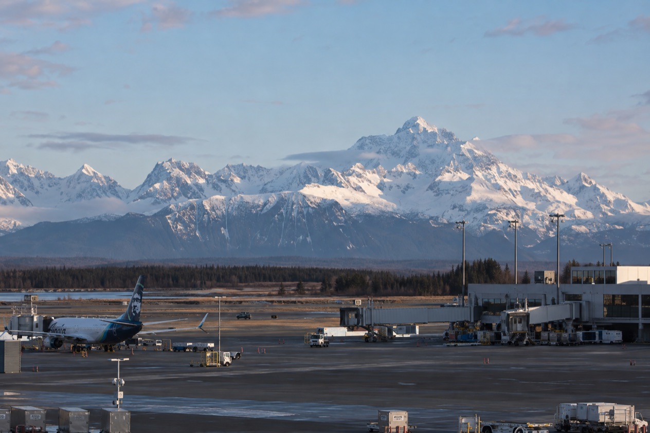
What is Ketchikan’s airport?
Ketchikan International Airport is the main airport of an island town in the rain-soaked far corner of Southeast Alaska, opened on August 4, 1973, and dedicated the next day. It serves a community of about eight thousand people, and it is a working airport first, the kind where a jet from Seattle and a floatplane bound for the rainforest share the same airspace.
The airport has two runways of very different kinds. One is a conventional asphalt strip for jets and wheeled aircraft. The other is a stretch of water, marked out for seaplanes, which tells you a good deal about how people get around this part of Alaska. Roads here are few, and the water and the sky do much of the work.
The runways and the airfield
The paved runway is designated 11/29, and the seaplane runway is designated WNW/ESE. The water runway is far wider than anything on land, which is simply what floatplanes need to take off and set down. The airfield sits close to sea level and spreads over a large area, a lot of flat ground in a landscape where most of the land tilts steeply upward into forest.
| Feature | Detail |
|---|---|
| Opened | August 4, 1973 |
| Asphalt runway 11/29 | 7,500 by 150 feet |
| Water runway WNW/ESE | 9,500 by 1,500 feet |
| Area | 2,600 acres |
| Elevation | 92 feet above mean sea level |
| Aircraft operations, 12 months ending January 31, 2019 | 15,959, an average of 44 per day |
What you see on the ground
Ketchikan calls itself the Rain Capital of Alaska, and the airport is where that nickname first hits you. Low cloud often hangs over the trees, and the view from the terminal tends to be water, wet pavement and forest in several shades of green. A rain jacket belongs in your carry-on rather than at the bottom of a checked bag.
What awaits beyond the terminal is a town with a deep Alaska Native heritage and a fishing tradition. Ketchikan holds the world’s largest collection of standing totem poles, spread across Saxman Totem Park, Totem Bight State Park, Potlatch Park and the Totem Heritage Center. Downtown is a National Historic Landmark District, and one of the town’s ZIP codes, 99950, is the highest-numbered in the United States, a small bit of trivia to enjoy while you wait for your bags.
How do you reach the town from the airport?
The town lies across the water from the airport, so the last stretch of your arrival is a crossing, and then you are in a compact waterfront town of steep streets, boardwalks and old wooden buildings. Once you are across, downtown Ketchikan is built for wandering, with the cruise docks, shops and museums gathered along the shore.
Arriving in a water-bound town
Ketchikan is an island community surrounded by rainforest and sea, and that shapes everything about getting around. Revillagigedo Island holds the town, the mountains rise right behind the buildings, and the harbor is the center of daily life. Float planes lift off and land on the channel throughout the day, fishing boats come and go, and the arrival by water gives you your first feel for the place before you have checked into a hotel.
If you are stepping off a ship rather than a plane, you arrive straight into the same downtown. The Ketchikan tour center is located in the Berth 2 Visitor Information Center, which makes that waterfront spot the natural place to get your bearings once you are in town.
First stops once you are in town
With a first afternoon in town, the Tongass Historical Museum is a good place to learn how fishing, timber and Alaska Native culture built Ketchikan. The Totem Heritage Center is another stop for anyone interested in the poles up close, and the Southeast Alaska Discovery Center explains the surrounding rainforest and the region’s people and wildlife.
Between May and September, the Great Alaskan Lumberjack Show is performed near Ketchikan Creek, which makes a lively break from museum visits. The Arts Humanities Council is part of the town’s cultural scene, and Misty Fiords National Monument is one of the major attractions of the area, though it lies beyond the town itself.
Other ways into town
Not everyone arrives by air. The Alaska Marine Highway ferry connects Ketchikan with Bellingham, Washington, and with Prince Rupert, British Columbia. The two routes are very different in scale: one is an overnight-and-beyond journey down the coast, the other a hop across the border waters.
| Alaska Marine Highway route | Crossing time |
|---|---|
| Ketchikan to Bellingham, Washington | 36 hours |
| Ketchikan to Prince Rupert, British Columbia | 6 hours |
What airlines fly there?
Alaska Airlines is the carrier named for Ketchikan, with nonstop jet service to Seattle, Juneau, Sitka and Wrangell. Seattle is the link to the rest of the country, while the other three are neighboring Southeast Alaska towns, so the same jet service ties Ketchikan into the chain of communities along the Inside Passage.
| Nonstop destination | Airline |
|---|---|
| Seattle, Washington | Alaska Airlines |
| Juneau | Alaska Airlines |
| Sitka | Alaska Airlines |
| Wrangell | Alaska Airlines |
Seattle and the way south
Seattle is the connection visitors from the Lower 48 will use. From there you can reach nearly anywhere in the country, which makes Ketchikan a realistic start for a Southeast Alaska trip even from far away. Seattle also lies 700 miles from Ketchikan, a gap that the water-bound geography of the Inside Passage makes feel larger than the map suggests.
The ferry to Bellingham is the slow alternative for travelers who want the journey to be part of the trip.
Juneau, Sitka and Wrangell
The nonstop links to Juneau, Sitka and Wrangell are what make a Southeast Alaska itinerary workable without a ship. Juneau is the state capital, Sitka carries strong Russian and Tlingit history, and Wrangell is a small town on its own island. All three are places where the rainforest, the water and the Alaska Native heritage shape the day, much as they do in Ketchikan.
A trip that strings these towns together lets you see how different each one feels while the landscape stays the same. Ketchikan, with its totem poles and its creek-side lumberjack show in season, makes a natural first or last stop on such a loop.
Seaplanes and the water runway
The water runway at the airport exists for seaplanes, and in a region where the main attractions often lie off the road system, floatplanes are part of the trip. Misty Fiords National Monument, one of the major attractions around Ketchikan, is the kind of place that makes the idea of a seaplane in the sky feel natural.
What operators run these flights and what they offer is a matter for each company. What you can count on is the sight itself: small planes on the water, the mountains behind them, and the cloud that often sits low over the channel.
Good to know before you go
Ketchikan earns its Rain Capital of Alaska nickname, so plan on wet weather and pack accordingly, since a jacket matters more than an umbrella in a town of steep streets and boardwalks. The Great Alaskan Lumberjack Show runs only between May and September, so it is not part of a trip outside those months. Downtown is compact enough to take in on foot once you are across the water, and the Berth 2 Visitor Information Center, home of the Ketchikan tour center, is the place to ask about what is on.
Sources
- Wikipedia, Ketchikan International Airport (https://en.wikipedia.org/wiki/Ketchikan_International_Airport), checked October 11, 2026
- Wikipedia, Ketchikan, Alaska (https://en.wikipedia.org/wiki/Ketchikan,_Alaska), checked October 11, 2026
- Visit Ketchikan (https://www.visit-ketchikan.com/), checked October 11, 2026
To plan your stay
- Best Time to Visit Ketchikan: Weather by Month, Long Summer Days, Totem Parks and Quiet Seasons
- Things to Do in Ketchikan: Totem Poles, Creek Street, Misty Fjords and Fresh Seafood
- Where to Stay in Ketchikan: Downtown, Ward Cove and How to Choose Your Base
- Know Before You Go to Ketchikan: Rain, Cruise Docks, Bears and Local Customs