
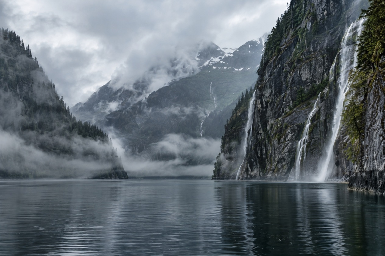
The cloud lifts off a granite wall just long enough to show a waterfall dropping straight into dark green water, then closes again. Cedar and hemlock cling to ledges that look too steep for roots, and the only sound is water falling somewhere out of sight. Misty Fjords National Monument is a wilderness of sheer-walled inlets in Southeast Alaska, and people see it from a boat or a floatplane out of Ketchikan.
Is visiting Misty Fjords National Monument worth it?
Yes, if you want to look at a landscape rather than tick off an attraction, and especially if you are already in Ketchikan with a day to give to the wilderness around it. It suits travelers who like big scenery seen quietly: stone walls, hanging waterfalls, and a sense of being far from any road. It asks little of you besides patience with the weather, since the name was earned by the clouds and rain that drift through these inlets.
What sets it apart from the other glacier-and-fjord outings in Alaska is the stone and the stillness. The monument lies about 40 miles east of Ketchikan, and because of its remoteness visitors arrive by boat or aircraft from Ketchikan or Juneau. There are no towns, no streets and no crowds of storefronts at the water’s edge.
Where Glacier Bay and Kenai Fjords are known for ice that calves into the sea, the ice here is long gone. What remains is the shape it left, pale granite carved into deep troughs and then wrapped in rainforest. Almost all of the monument is designated wilderness, and it feels that way from the first minute.
It also works as a counterpoint to Ketchikan itself, a lively cruise town of totem poles, galleries and boardwalks over the water. A day in the fjords gives you the other half of Southeast Alaska, the part that has hardly changed.
What to see at Misty Fjords National Monument
The monument is a place to take in as a whole, but a few features anchor any visit. They are the walls, the water and one odd rock standing in the middle of a channel.
The granite walls and U-shaped valleys
The light-colored granite here is about 50 to 70 million years old, and glaciers later gouged it into deep U-shaped troughs. Those troughs are the fjords. Their walls are near-vertical and often rise 2,000 to 3,000 feet above sea level, and they drop another 1,000 feet below it, so the water under a boat is as deep as the cliffs are tall.
Look for the streaks where water has run down the stone for centuries, and for the thin forest holding onto ledges and cracks. Waterfalls appear after rain and often vanish into mist before they reach the bottom. From the air, the pattern of the glacial valleys is easier to read, with one trough opening into the next. From the water, the scale becomes physical, because the walls seem to lean over you.
New Eddystone Rock
A column of basalt 237 feet tall stands alone in the middle of Behm Canal, and it is the landmark of the monument. It was named for the Eddystone Lighthouse off England, which its shape recalls, and it looks almost deliberate against the water and the far hills. The dark volcanic rock contrasts with the pale granite on the shores around it.
Seen from a boat, it is a quiet punctuation mark on a long crossing. Seen from a floatplane, it is a small tower on a wide gray channel, and it shows how much open water surrounds the inlets. Birds often use rocks like this for perching, so keep an eye out for them.
Rainforest, wildlife and the weather itself
The shoreline is Tongass National Forest rainforest, dark with spruce, hemlock and cedar and thick with moss. Seals, eagles and other coastal wildlife are chances rather than promises, and some visitors come across them while scanning the shore. The clouds and drizzle are part of the scene. A low ceiling turns the cliffs into shadows that appear and disappear, and travelers remember those hours best.
Hours, tickets and rules
Misty Fjords is a wilderness area, not a gated attraction, so there is no front door with posted opening hours. The monument is administered by the U.S. Forest Service as part of the Tongass National Forest, and it covers more than two million acres of the Alaska Panhandle. You see it through the trips that go there, and the operator you choose determines your schedule and what you pay.
The monument was originally proclaimed by President Jimmy Carter in December 1978, and it was then spelled Misty Fiords National Monument. You will still see that spelling on some signs and brochures. All but a small part of the land is designated wilderness, which shapes the experience. The idea is to look, listen and leave the place as you found it, with no development along the water to distract you.
How to get to Misty Fjords National Monument
You get there by boat or by aircraft. Because of the remoteness of the monument, visitors arrive from Ketchikan or Juneau, and Ketchikan is the nearer base. It sits on Revillagigedo Island in the Inside Passage, with the monument about 40 miles to the east, and from the town you reach it across the water or through the air.
By floatplane from Ketchikan
A floatplane trip to Misty Fjords leaves from Ketchikan, and it is the way to see the whole shape of the place in one sweep. From the air the fjords read like a map, with long straight channels, hanging valleys and sheer rock faces. The planes can land on the water, which puts you at the foot of the cliffs for a few moments.
The tour desks at the Berth 2 Visitor Information Center are where Ketchikan’s tour center is located. Anyone arriving off a cruise ship will walk past it, and it is a natural place to start asking about trips.
By boat, charter or kayak
A boat brings you down into the fjords at water level, which is how the walls and waterfalls feel their tallest. More adventurous travelers choose an overnight charter or spend days exploring by kayak, paddling beneath the cliffs and camping in the quiet. Wildlife and sightseeing tours also run from Ketchikan, and fishing charters can be booked in the town.
Juneau is the other gateway named for the monument, though Ketchikan is the base people use. Once you are there, the town makes a pleasant staging point, with its walkable downtown and its waterfront.
When to visit Misty Fjords National Monument
Plan for weather as the main variable, whatever the month. Ketchikan is one of the rainiest cities in North America, with just over 160 inches of precipitation in an average year, and the fjords share that climate.
Low cloud and rain are the normal state of things, and they give the monument its mood. A clear day shows the full height of the granite, but a gray one has its own beauty, with mist wrapped around the peaks and waterfalls swelling from the rain.
Cruise ships that ply the Inside Passage visit Ketchikan from early May through late September, so the town is busiest across that stretch. The operators who run trips into the fjords are tied to the same rhythm. Outside those months Ketchikan is quieter, which is a different kind of visit, and the town keeps a more local face.
As for the time of day, a trip in the morning or afternoon changes the light on the cliffs. Clouds often lift and settle through the day, so a patient visitor may see the same wall appear and disappear. Wildlife sightings are chances at any hour, and you may spot them without planning for it.
Tips for your visit
Bring a rain jacket and a layer for the water, because the weather decides the day. A camera with a good zoom helps for waterfalls and far cliffs, and binoculars are useful for birds and shoreline.
Downtown is easy to walk, with historic buildings, galleries, shops and locally made goods. Creek Street was once a raucous red-light district and, during Prohibition, a row of speakeasies, and it now holds quieter establishments that keep its historic charm. It is the place to wander before or after a day on the water.
Ketchikan is also a town shaped by Tlingit, Haida and Tsimshian cultures. Totem Bight State Historical Park, the Totem Heritage Center and Saxman Totem Park are the places to see totem poles, and the Tongass Historical Museum and the Southeast Alaska Discovery Center add context on the town and the surrounding forest. Pairing one of them with the fjords gives you the people and the land in a single stay.
Ask the operator you choose about the details of access and accessibility. Floatplane, boat and kayak trips are very different experiences, and each suits a different traveler. Families and those who want a gentler pace can weigh those differences when picking among them.
Good to know before you go
Think of the monument as a place you visit through a trip, so your costs and schedule come from the operator you pick in Ketchikan. The town offers wildlife and sightseeing tours, floatplane flights and fishing charters, and the Berth 2 Visitor Information Center is where its tour center is found.
Expect cloud and rain at some point, and treat them as part of the scenery. The land is wilderness under Forest Service care, so the best habit is the simplest one: look closely, take only photographs and leave the rainforest as it is.
Sources
- Wikipedia, Misty Fjords National Monument (https://en.wikipedia.org/wiki/Misty_Fjords_National_Monument), checked October 11, 2026
- Visit Ketchikan, things to do (https://www.visit-ketchikan.com/things-to-do/), checked October 11, 2026
- Wikivoyage, Ketchikan (https://en.wikivoyage.org/wiki/Ketchikan), checked October 11, 2026