
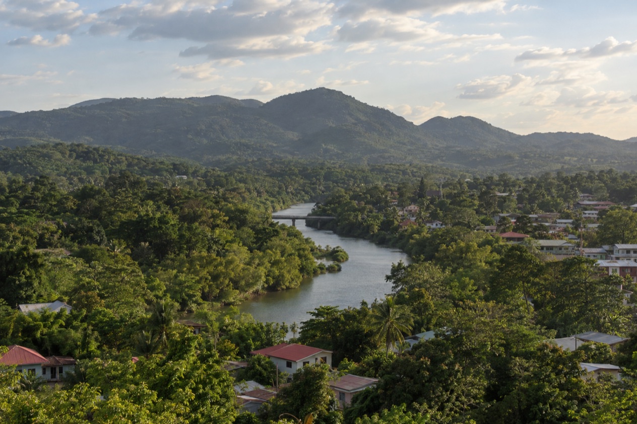
Early in the morning in San Ignacio, the Hawkesworth Bridge hums with bicycles and pickup trucks crossing the Macal River, and the smell of fry jacks drifts out of kitchens near the market. Up on the hills above town, the stone plazas of Cahal Pech wait in the green light, and farther out the roads run toward caves, pine forest and temples that rise out of the jungle. San Ignacio is the hub of western Belize, a river town for travelers who want ruins, rainforest and good food in the same few days.
What are the best things to do in San Ignacio and the Cayo District?
The best things to do here are the Maya sites, the caves and the rivers, with a good meal and a quiet evening in town between them. The Cayo District is built around ancient cities that sit within reach of one another, and around water that has carved caves and valleys through the limestone. Town itself is small enough to enjoy at a walking pace.
Think of the district in layers. The first is San Ignacio, with its market, its bridge and a Maya site on the hill. The second is the ring of ruins and villages around it. The third is the high country to the south, where pine forest, creeks and the largest Maya city in Belize sit well away from the river valley. The essentials, in the order most travelers meet them:
- Cahal Pech, the hilltop Maya site that looks down on San Ignacio and can be reached on foot from the town center.
- Xunantunich, reached by a hand-cranked river ferry, with El Castillo rising above the Mopan River valley.
- Caracol, the far-off Maya city in the forest whose main temple, Caana, is the tallest manmade structure in Belize.
- Actun Tunichil Muknal, the cave with skeletons, ceramics and the Monkey Pot, set in the Tapir Mountain Nature Reserve.
- Barton Creek Cave, a natural cave that is both an archaeological site and a tourist destination.
- Mountain Pine Ridge Forest Reserve, a high pine landscape with creeks and long views.
- The San Ignacio market and the town’s tables, for stew chicken, fry jacks, tamales and fresh juices.
- An evening on Burns Avenue, with a cold Belikin, live music and a quiet walk back across town.
Sights and landmarks in San Ignacio and the Cayo District
The landmarks of Cayo are mostly Maya, and they come in different moods: a hill site you can walk to from your hotel, a tall temple above a river ferry, and a string of quieter ruins in the forest. In town, the landmark is the river itself and the bridge that crosses it. Together they give you a day or two of sightseeing before you ever drive to the farther places.
Cahal Pech
Cahal Pech overlooks San Ignacio from a hill and is about a ten-minute walk from the town center, which makes it the easiest ruin to fit around a meal or a sunset. The name means the Place of Ticks, and it sounds less grand than the site feels. Thirty-four structures cluster around courtyards, with steep stairways, narrow passages and low palace rooms that show how the architecture grew and changed over centuries.
The site has evidence of habitation going back to 1200 BCE, which makes it one of the oldest recognizably Maya sites in western Belize. The setting adds to the visit.
The hill sits high above the Macal River and looks out over the place where the Macal and the Mopan rivers meet, and on a clear day the valley spreads out below the temple tops. Tickets are priced in two categories, resident and non-resident, and by age group, including children, adults and Belizean Golden Citizens.
Xunantunich
Part of the pleasure of Xunantunich is how you reach it. You cross the Mopan River on a hand-cranked ferry near the village of San Jose Succotz, and the ruins rise on a ridge above the water, close to the Guatemala border. The core of the site holds six plazas surrounded by temples and palaces, and the walk between them gives you a feel for a small Maya capital with its ceremonial heart intact.
El Castillo is the centerpiece, 130 feet tall and the second tallest structure in Belize after the temple at Caracol. Its stucco friezes and the wide views over the river valley and the forest toward Guatemala are what people remember. The site opens every day, including Sundays and holidays.
| Site | Open |
|---|---|
| Xunantunich | Every day, 8:00 am to 5:00 pm, including Sundays and public and bank holidays |
San Ignacio town and the Hawkesworth Bridge
San Ignacio sits on the banks of the Macal River and shares its valley with the sister town of Santa Elena. The two are joined by the Hawkesworth Bridge, the only suspension bridge in Belize and a one-lane crossing built in 1949. Traffic takes turns, pedestrians wander across, and the view down the river is a good first look at the town.
Together the twin towns make up the third largest urban area in the country, home to about twenty-one thousand people. That is large enough for a market, hospital, banks and a lively main street, and small enough that you will find your bearings in an afternoon. Walk the market streets, stop for a juice on a corner, and look at the old wooden houses with their porches on the slopes.
Other Maya sites in the district
Beyond the headline ruins, Cayo holds several quieter ones: Baking Pot, Lower Dover and El Pilar. They sit in farmland and forest rather than on a tourist circuit, and they suit travelers who like their archaeology with birdsong and few other footsteps. El Pilar in particular is known for plazas reclaimed by trees, so the forest and the stonework seem to share the same hill.
Seeing two or three of these ruins across a stay teaches you how the Maya world was laid out, with river valleys dotted by cities of different sizes. Each has its own mix of mounds, plazas and stairways, and each tells a slightly different part of the story.
Outdoor things to do in San Ignacio and the Cayo District
Outdoors in Cayo means rivers, limestone caves and a pine forest on high ground, all within the same district. The Macal and the Mopan are the two major rivers, and they shape the valley, the farms and the boat landings. The Cayo District borders Guatemala to the west and reaches across to Orange Walk, Belize, Stann Creek and Toledo districts, so its landscape runs from river flats to hills.
Mountain Pine Ridge Forest Reserve
Mountain Pine Ridge feels like another country after the lowland jungle. The reserve was set up in 1944 to protect the native pine forests, and it covers roughly 400 square kilometers of rolling country with the Macal River forming its western and southern edges. Pines, red earth and open sky replace the dense broadleaf forest below, and the air has a different smell, resinous and dry.
Elevation averages between 400 and 700 meters, with Baldy Beacon the high point of the reserve. The rainy season runs from July to February and the dry season from February to May, which shapes how the creeks and the forest look at different times of the year. Expect to spend your time on viewpoints, creeks and quiet roads rather than on a single headline sight.
Barton Creek Cave
Barton Creek Cave lies in the upper Barton Creek area near San Ignacio, and it is both an archaeological site and a tourist destination. Its passage follows the creek into the hillside, with formations in the limestone and pottery left by the Maya. Pottery fragments show the cave was used between the Early Classic and the Late Classic periods, roughly 200 to 900 CE.
The cave has been surveyed to about five miles, and the remains of at least 28 people have been found inside. That history gives the place a hushed, serious feel, and it is the thing to keep in mind as you look at the walls and the water. It is a good counterpart to the temple climbs, since you see the Maya underworld as well as their cities.
The river valleys and farm country
The Macal and the Mopan give Cayo its character. From San Ignacio you can look down on the Macal from the Cahal Pech hill and watch it widen toward the meeting of the two rivers. Bird life is a large part of the pleasure, and mornings along the riverbanks bring herons, kingfishers and parrots in the trees.
Farms and orchards fill the valleys between the ruins and the pine hills. Spanish Lookout, a Mennonite community that has modernized to a large degree, runs dairies and workshops in the district, and its produce shows up in San Ignacio kitchens. Drive the back roads and you see cattle, citrus, corn and wooden farmhouses against the green hills.
Day trips from San Ignacio and the Cayo District
Most day trips from San Ignacio head to a ruin, a cave or the high pine country, and each one takes a different kind of day. Caracol is the far one, Actun Tunichil Muknal is the cave, Mountain Pine Ridge is the scenic road, and Xunantunich is the ferry ride across the river. San Ignacio works as a base because all of them start from the same Western Highway region.
Caracol
Caracol lies south of San Ignacio and Xunantunich, deep in the forest of the Cayo District. The road to it is paved for its last 9.9 miles and connects to the Western Highway between San Ignacio and Belmopan, and to Santa Elena. The site was declared a national park in 1991, and it spreads across a large area of forest with plazas, causeways and temples.
Caana, the largest building, is the tallest manmade structure in Belize at 141 feet. Climbing its terraces is not something to assume, but standing at its base and looking up at its bulk gives a sense of the scale of the city. Howler monkeys and birds often fill the canopy around the plazas, and the forest feels very quiet after the long road in.
Actun Tunichil Muknal
Actun Tunichil Muknal, known locally as ATM, is a cave near San Ignacio in the Tapir Mountain Nature Reserve. It is known as a Maya archaeological site with skeletons, ceramics and stoneware. The main cave system is about three miles long, with a river passage of about two miles that ends at an upstream sump.
One artifact inside, the Monkey Pot, is one of just four of its type found in Central America. The cave draws people interested in the Maya ritual world, since the objects lie where they were left. It is a very different day from a temple visit, with darkness, water and silence in place of sun and stone.
Mountain Pine Ridge and Barton Creek
The scenery changes as the road climbs, with orchards giving way to red-soil hills and then to pine forest. Stopping at lookouts and creek crossings is part of the day.
This outing suits travelers who want landscape as much as archaeology, and who like to see the same district in three or four different guises in a few days. The rainy season in the reserve runs from July to February, so the creeks and the forest change with the calendar.
Benque Viejo del Carmen and the border country
Benque Viejo del Carmen is the westernmost town in Belize, right on the Guatemalan border across from Melchor de Mencos. The Mopan River runs along its northern and western edges. Weekday mornings bring students walking across the border crossing from Melchor de Mencos to board school buses, which gives the town a cross-border character you notice in its accents and its food.
A visit here is more about atmosphere than monuments: the main street, the church, the market stalls and the river. It also puts you near Xunantunich and the Succotz ferry, so the two can sit in the same outing.
Belmopan and beyond
Belmopan, the capital, lies east of San Ignacio, and a bus takes one hour between them. It is a quiet administrative town rather than a sightseeing destination, and most people pass through on the way to the coast or the airport.
What to eat in San Ignacio and the Cayo District
Eating in Cayo means Belizean staples cooked with Creole, Maya, Mestizo and Mennonite touches, served in family-run places and market stalls. Breakfast might be fry jacks, puffy triangles of fried dough, with beans, eggs and fresh cheese. Johnnycakes, a denser bread, arrive warm in a basket with butter and jam.
Lunch is where the country’s plate lives: stew chicken with rice and beans and a scoop of coleslaw or potato salad, slow-cooked with recado, the red spice paste. Fried plantain on the side is standard. Local fish and shrimp appear on menus, as do cow foot soup and escabeche, an onion-heavy chicken soup scented with vinegar and spice.
Market food and street snacks
Near the Guatemalan border, the Mestizo influence shows in tamales wrapped in banana leaf, in garnaches (fried tortillas topped with beans, cheese and cabbage), in salbutes and in panades, small fried pockets filled with fish or beans. These are cheap, quick and filling, and you eat them standing near the stall where they were fried.
The San Ignacio market is a good place to meet these foods and the produce behind them: papaya, watermelon, mango, limes, cilantro, plantains, tomatoes, chiles and cacao. Fresh juices are everywhere, from watermelon to limeade, and a cold glass is a reward after a ruin visit.
Mennonite and farm products
Mennonite farms of the district supply cheese, milk, bread, peanut butter and honey, and you can find them in town shops and at roadside stands. The ethnic Mennonite population of Belize was 15,249 in 2022, and Spanish Lookout in Cayo is one of the larger communities, with farms and workshops that supply the region.
A loaf of sweet bread or a block of white cheese makes good picnic food for a ruin visit. Cacao is also grown in the country, and you may see chocolate made from local beans, a nod to the Maya who first prized the drink.
Drinks
Belikin is the national beer and shows up in every bar, with the stout as a darker option. Rum punch, rum with fruit juice and a splash of grenadine, is a standard evening drink. Local fruit wines made from cashew, craboo or blackberry turn up on some menus.
Coffee in the morning is common, often alongside a plate of eggs and fry jacks. Seaweed shakes and cacao drinks are other regional specialties, and a small café will often serve hot chocolate that tastes quite different from the packaged kind.
Things to do in San Ignacio and the Cayo District at night
Nights in San Ignacio are relaxed, built around a few bars, restaurants and live music rather than a nightclub scene. The town closes in gently, and the quiet hours give the river valley a sound of its own.
Burns Avenue and the bars
A typical evening begins with dinner on a patio, often with a plate of stew chicken, grilled fish or tamales, followed by a drink in one of the bars. Some places have live music, with local bands playing reggae, soca, punta and Latin tunes, and dancing sometimes spills onto the floor. The mood is easy and social, with travelers and locals sharing tables.
Garifuna rhythms and Creole kriol songs are part of the sound of Belize, and you may hear them in covers or in special events. Rum punch and a bowl of fresh lime go well with an early evening on the porch.
Quiet evenings
Many people spend the night at lodges outside town, where the evening means a porch, a river and a very dark sky. Frogs, insects and night birds supply the sound, and the stars are bright when the sky is clear. A walk on the lodge grounds or a quiet dinner by the river fits the pace.
In town, you can finish the evening with a stroll toward the Hawkesworth Bridge, a juice or an ice cream from a shop and a look at the river in the dark. Early nights are common, since ruin and cave days start with the daylight.
Night in the forest
The forest is lively after dark, with frogs, nocturnal insects and sometimes owls and bats calling around lodges. Wildlife is a chance rather than a promise, and a quiet walk often brings more than a noisy one.
Back in town, the market streets grow quiet and the sound of the river returns. It is the kind of place where the best evening is a slow one.
Things to do in San Ignacio and the Cayo District with kids
Children in Cayo get a mix of ruins to scramble around, animals to spot and a ferry to ride, which makes the district a hands-on place to learn about the Maya. The hand-cranked ferry across the Mopan River is the sort of ride children remember, and the stone plazas of Cahal Pech and Xunantunich are open spaces where they can see how a Maya city was laid out.
Ruins and ferry rides
At Cahal Pech, the walk up from town and the maze of courtyards and stairways make for a good first introduction, and the site’s age gives parents a chance to talk about the Maya and what they built. Ticket categories include a minor price for younger visitors, with separate age brackets.
Xunantunich adds the ferry crossing, a hand-cranked ride across the Mopan River, before the climb up the ridge to the plazas. The setting looks and feels like an adventure, and El Castillo shows the scale of Maya building from the ground. Children often enjoy spotting stucco carvings and lizards on the stone.
Animals, birds and farms
Cayo’s lodges and farms often have gardens and trails where children can look for butterflies, birds, iguanas and tree frogs. Some properties keep small animal exhibits or conservation projects. The forest is full of life, and a patient child with sharp eyes can spot a lot from a quiet bench.
Farms in the Mennonite country are another window into local life, with cattle, orchards and a roadside stand selling fresh bread or cheese. A stop at a stand makes a simple lesson in where food comes from.
What to keep in mind with children
Ruin days involve sun, stone steps and a lot of walking, so hats, water and sunscreen matter, and a child who tires easily may prefer a smaller site. Caves and long drives are bigger undertakings, so match the day to the age of the child. The high country and the far ruins take longer to reach than the sites close to town.
Bug repellent is useful in the forest, since the district is green and wet for part of the year. In town, the hospital in Santa Elena, La Loma Luz Hospital, serves the twin towns. A relaxed pace with a swim in the hotel pool or a juice stop in the market suits a family stay well.
Good to know before you go
The U.S. State Department rates Belize Level 2, “Exercise increased caution”, because of crime, and says the south side of Belize City has historically had the highest concentration of violent crime.
San Ignacio lies about 63 miles west of Belize City and about 22 miles west of Belmopan, and the bus between San Ignacio and Belmopan takes an hour. Hopkins is reached by bus via Belmopan in three hours, which makes the Cayo District one stop on a longer route. The Atlantic hurricane season runs from June 1 to November 30, and the Cayo District lies inland in the west of the country.
The Belize dollar is the local currency, and the ruins, the market and the river are all part of the same small area. Keep your plans flexible in the rainy season, when roads and creeks change from one week to the next.
Sources
- Wikipedia, San Ignacio, Belize (https://en.wikipedia.org/wiki/San_Ignacio,_Belize), checked October 11, 2026
- Wikivoyage, San Ignacio (Belize) (https://en.wikivoyage.org/wiki/San_Ignacio_(Belize)), checked October 11, 2026
- Wikipedia, Cayo District (https://en.wikipedia.org/wiki/Cayo_District), checked October 11, 2026
- Wikipedia, Xunantunich (https://en.wikipedia.org/wiki/Xunantunich), checked October 11, 2026
- Wikipedia, Cahal Pech (https://en.wikipedia.org/wiki/Cahal_Pech), checked October 11, 2026
- Wikipedia, Caracol (https://en.wikipedia.org/wiki/Caracol), checked October 11, 2026
- Wikipedia, Mountain Pine Ridge Forest Reserve (https://en.wikipedia.org/wiki/Mountain_Pine_Ridge_Forest_Reserve), checked October 11, 2026
- Wikivoyage, Mountain Pine Ridge (https://en.wikivoyage.org/wiki/Mountain_Pine_Ridge), checked October 11, 2026
- Wikipedia, Actun Tunichil Muknal (https://en.wikipedia.org/wiki/Actun_Tunichil_Muknal), checked October 11, 2026
- Wikipedia, Barton Creek Cave (https://en.wikipedia.org/wiki/Barton_Creek_Cave), checked October 11, 2026
- NICH ticketing, Xunantunich (https://ticketing.nichbelize.org/product/xunantunich/), checked October 11, 2026
- NICH ticketing, Cahal Pech (https://ticketing.nichbelize.org/product/cahal-pech/), checked October 11, 2026
- Wikipedia, Benque Viejo del Carmen (https://en.wikipedia.org/wiki/Benque_Viejo_del_Carmen), checked October 11, 2026
- Wikipedia, Melchor de Mencos (https://en.wikipedia.org/wiki/Melchor_de_Mencos), checked October 11, 2026
- Wikipedia, Mennonites in Belize (https://en.wikipedia.org/wiki/Mennonites_in_Belize), checked October 11, 2026
- Wikipedia, Tourism in Belize (https://en.wikipedia.org/wiki/Tourism_in_Belize), checked October 11, 2026
- U.S. Department of State, Belize Travel Advisory, Level 2, March 11, 2026 (https://travel.state.gov/), checked October 11, 2026
- NOAA National Hurricane Center, Climatology (https://www.nhc.noaa.gov/climo/), checked October 11, 2026
To plan your stay
- Best Time to Visit San Ignacio and the Cayo District: Weather, Maya Sites and Seasons
- Where to Stay in San Ignacio and the Cayo District: Riverside Lodges, Town Stays and the Mountain Pine Ridge
- San Ignacio and the Cayo District from Belize City: Distance, Bus, Rental Car and Day Trips
- Know Before You Go to San Ignacio and the Cayo District: Entry, Money, Getting Around and Health