
The road climbs out of the green valleys and the broadleaf forest gives way to open stands of pine, with red earth showing between the trunks and a resinous smell in the air. Then the ground drops toward a river, and a great dark arch appears in the hillside, tall enough to make the people standing at its mouth look small. Rio Frio Cave sits in the Mountain Pine Ridge of the Cayo District, and a visit here is about the scale of the opening, the light falling into it and the river that runs through.
Is visiting Rio Frio Cave worth it?
Yes, if you like landscapes that make you stop and look up, and if you are happy to give a day to the Mountain Pine Ridge rather than to a single stop. Rio Frio Cave has the largest entrance of any cave in Belize, and that single fact explains much of its pull.
You do not need to be a caver to appreciate it. The drama is in the proportions: a river, a wall of stone and an opening that swallows the daylight.
What sets it apart from other caves in the same part of Belize is the kind of experience it offers. Barton Creek, also in the reserve, is a river cave that may extend for 4.5 miles, a place defined by its length and its darkness. Rio Frio is defined by its mouth. It is a cave you see as much as one you go into, and it fits naturally into a day spent among the pines, the creeks and the waterfalls of the ridge, including Big Rock Falls and Hidden Valley Falls.
It also suits travelers who like a quieter, more open-air side of Cayo. The reserve is a place of forest, rock and water, with no resort strip and no crowd of vendors implied by its setting. That makes it a good match for photographers, for people who enjoy geology and for anyone building a day around the ridge’s natural sights.
What to see at Rio Frio Cave
The great arch of the entrance
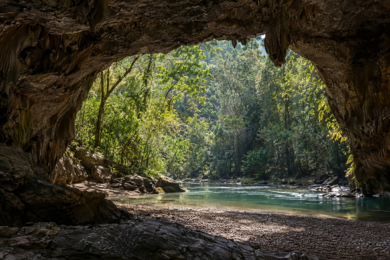
The entrance is the reason to come. The limestone opens into a wide, high vault, and what strikes you first is how far the daylight reaches inside before it fades. Walls streaked with mineral stains and ferns clinging to the lip of the opening frame the view, and the contrast between the bright forest outside and the cool shadow within is the picture most visitors carry home.
Look up as well as ahead. Caves like this often shelter swallows, swifts or bats near the mouth, and you may see birds darting in and out against the dark. The shapes of the rock, with its ledges, folds and old water marks, tell a long story of a river cutting its way through the hill over a very long span of time.
The Rio Frio itself
The river is the architect here. The Rio Frio is the cave’s reason for being, and it is the reason the passage is so wide. Its water enters one side of the hill and emerges on the other, passing over stones that have been smoothed by many seasons of flow. Standing near the opening, you hear the water before you fully take in the scale of the rock around it.
The name means cold river in Spanish, and the sound and feel of moving water in the shade suit it. The forest on either bank is thick with ferns, mosses and broadleaf growth that contrast with the pines on the ridge above, so a short look around shows two quite different habitats side by side.
The pine ridge around it
The cave lies inside the Mountain Pine Ridge Forest Reserve, set aside in 1944 to protect and manage the native Belizean pine forests. The ridge is unlike the lowland jungle many people picture for Belize: the trees are pines, the soil is reddish, and the elevation averages between 1,312 and 2,296 feet, which shapes the whole landscape.
On the way to the cave you pass through this open pine country, and it is worth looking at it properly. The light is different, the understory is lighter, and the Maya Mountains give the horizon a long, folded shape. The reserve covers roughly 106,000 acres, so the cave is one small point in a very large protected area.
Hours, tickets and rules
Rio Frio Cave lies inside a forest reserve rather than a staffed resort, and the setting tells you most of what to expect. There are no real services anywhere within Mountain Pine Ridge, so the cave is a place to arrive prepared and to enjoy for what it is: a natural landmark in open country.
The park roads are unpaved, and the reserve is not served by any real bus service. That shapes how a visit works. You are traveling through a working forest landscape on rough tracks, and the pace of the day follows the road rather than a timetable of attractions. Lodges inside the reserve usually provide phone and internet for their guests, which is useful to know if you are staying on the ridge.
Blancaneaux Lodge, one of the places to stay in Mountain Pine Ridge, sets check-in at 3PM and check-out at noon. That is a handy marker if you are planning a night on the ridge and fitting the cave into the day before or after. For other hikes in the reserve, such as Big Rock Falls, the advice is to head home well before sunset because the hike out can be steep.
How to get to Rio Frio Cave
The cave is in the Mountain Pine Ridge Forest Reserve in the Cayo District, so every route to it ends on the reserve’s roads. Those roads are unpaved and no real bus service reaches the reserve, which is the most important thing to understand about the approach. The reserve is large, roughly 400 square kilometers, and the Macal River forms its boundary on the west and south sides.
As you enter the ridge, the scenery changes quickly. Broadleaf forest and farmland give way to pine, and the track becomes a ribbon of reddish earth. The elevation rises, with the average between 400 and 700 meters across the reserve and the highest point at Baldy Beacon. The lowest point, down on the Macal River, sits at 394 feet, which gives you a sense of how much relief the reserve contains.
Because there are no real services within the reserve, plan the journey as one that carries everything with it. Lodges in the area usually provide phone and internet to their guests, which makes them useful bases for exploring the ridge, including this cave and its neighbors.
When to visit Rio Frio Cave
The ridge has two seasons. The rainy season runs from July to February, and the dry season from February to May. A visit in the drier months suits anyone who wants clear views of the pine country and the open sky around the cave, while the wet months bring a greener, lusher look to the forest on the riverbanks.
In the dry season, temperatures in the reserve may reach 102°F, so the shade at the mouth of the cave and the cool of the river feel especially welcome then. If you travel in the rainy months, expect the landscape to look at its greenest and the creeks and falls of the ridge to be part of the scenery.
The Atlantic hurricane season runs from June 1 to November 30, which overlaps with the rainy season. Plan a day on the ridge with that in mind. Because the roads are unpaved, it is the sort of trip where the day’s plan can follow the conditions, and leaving time to get out of the reserve well before dark is sensible, as the advice for Big Rock Falls also reminds you.
Tips for your visit
Bring what you need for a day in open country, since there are no real services anywhere within Mountain Pine Ridge. Water, food, sun protection and shoes with a good grip belong in the bag. A camera is the other essential, as the scale of the entrance is easier to appreciate in pictures taken from a little distance back.
Pair the cave with other stops on the ridge. Big Rock Falls on Privassion Creek is a larger waterfall, Hidden Valley Falls is another of the reserve’s cascades, and the river cave at Barton Creek is a very different kind of cave. Together they make a varied day of rock, water and forest, and each one shows a different side of the same landscape.
If you plan to stay overnight, lodges such as Blancaneaux Lodge put you in the heart of the ridge, with check-in at 3PM and check-out at noon. Whatever you choose, build the day so you are leaving the reserve with daylight to spare, because the tracks are unpaved and some hikes on the ridge have steep returns.
Good to know before you go
The U.S. State Department rates Belize Level 2, “Exercise increased caution”, because of crime, and says the south side of Belize City has historically had the highest concentration of violent crime.
Mountain Pine Ridge has no real services, so settle practical matters before you enter the reserve. The Atlantic hurricane season runs from June 1 to November 30, and the wet months of the ridge fall within it, which is worth remembering when you choose your dates. Beyond that, bring what you need for the day, travel with the reserve’s unpaved roads in mind, and leave time to enjoy the cave without rushing the way out.
Sources
- Wikipedia, Mountain Pine Ridge Forest Reserve (https://en.wikipedia.org/wiki/Mountain_Pine_Ridge_Forest_Reserve), checked October 11, 2026
- Wikivoyage, Mountain Pine Ridge (https://en.wikivoyage.org/wiki/Mountain_Pine_Ridge), checked October 11, 2026
- U.S. Department of State, Belize Travel Advisory, Level 2, March 11, 2026 (https://travel.state.gov/), checked October 11, 2026
- NOAA National Hurricane Center, Climatology (https://www.nhc.noaa.gov/climo/), checked October 11, 2026