
The ferry across the Mopan River is a small flat deck moved by hand, and the crossing sets the tone for the whole visit: slow, a little quaint, and pointed straight at a ridge of jungle. Beyond it, the road climbs to a hilltop of plazas, temples and palaces, with the great pyramid of El Castillo rising above the trees. Xunantunich is a half-wild, wide-open Maya site in western Belize, and a visit here is about walking through an ancient capital and looking out over the forest from its highest roof.
Is visiting Xunantunich worth it?
Yes, if you want a Maya site that feels like an adventure from the first minute and still has real architecture to look at. It suits curious travelers of nearly any age who like ruins, views and a bit of dust on their shoes, and it works as a first Maya site in Belize.
What sets it apart from the other ruins of the Cayo District is the approach and the scale. Cahal Pech sits close to the town of San Ignacio, while Xunantunich waits across a river, on a ridge above the Mopan, within sight of the Guatemala border.
The core covers about one square mile, with six plazas surrounded by more than 26 temples and palaces. That gives you room to wander rather than a single monument to photograph.
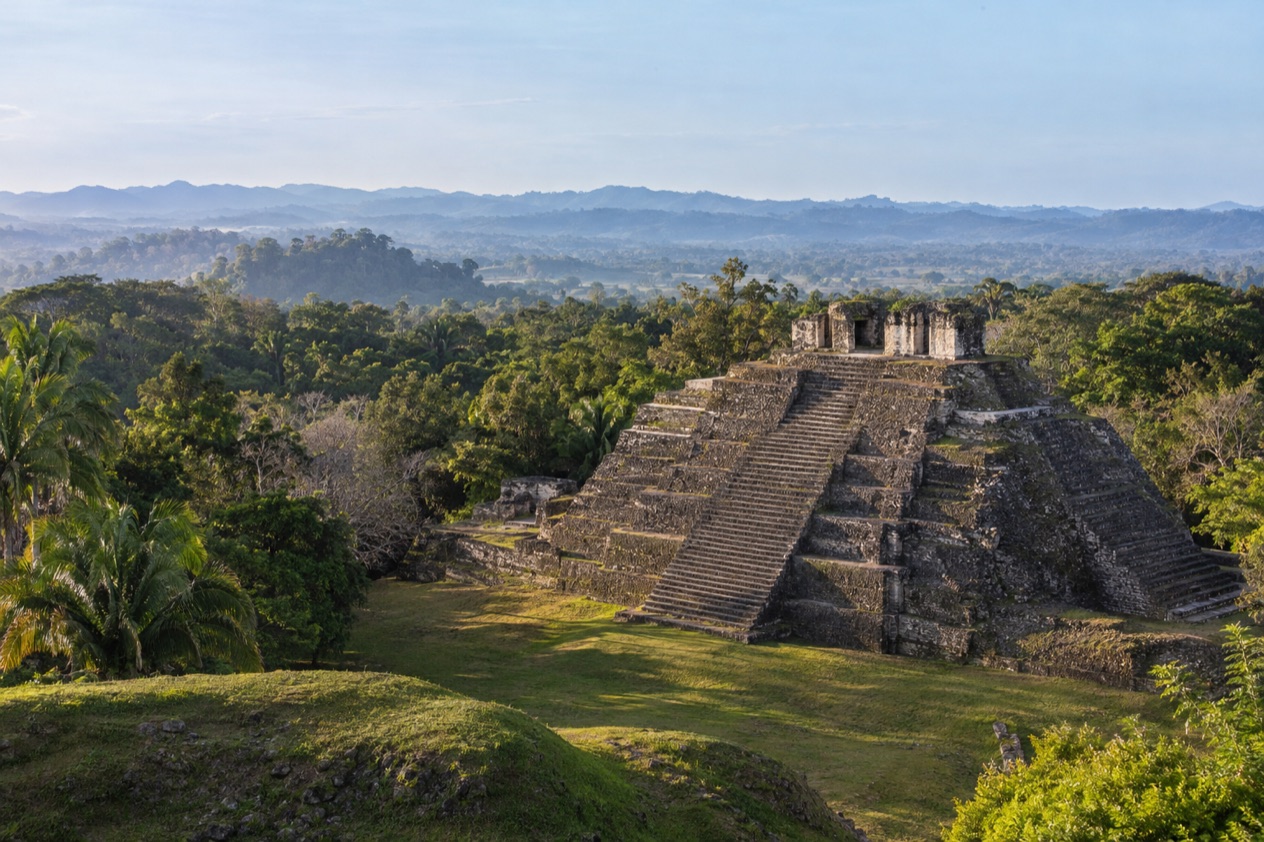
El Castillo is the draw. It is the second tallest structure in Belize after the temple at Caracol, and from its top the view runs over jungle, ruins and into Guatemala. It is also Belize’s most-visited Maya site, and the reason is easy to see once you stand in the main plaza and look up.
The name means Maiden of the Rock in the Maya languages Mopan and Yucatec, and it carries a ghost story that guides like to tell. The site was a civic ceremonial center of the Belize Valley in the Late and Terminal Classic periods, and at that height nearly 200,000 people lived in the valley around it. That context makes the empty plazas more striking.
What to see at Xunantunich
El Castillo, the great pyramid
El Castillo stands 130 feet tall and dominates everything around it. Its stepped bulk rises from Group A, the central and most significant of the site’s four groups, and the upper levels once carried carved stucco friezes, the kind of decoration that made the building a statement of power as well as a temple.
Look at it from the plaza first, then walk around to see how the terraces change from side to side. The top is known for a 360-degree view of forest canopy, the other mounds of the site and the hills across the border. Guides often tell how the pyramid was built and rebuilt over generations, a common pattern in Maya cities.
The plazas, palaces and Group A
Around the main pyramid, the plazas show how a Maya capital was organized. Six plazas are ringed by temples and palaces, and the layout of Groups A, B, C and D reflects different roles within the city: ceremony, elite residence and public space. Walking from one open square to the next gives a sense of how people once moved through the city.
The grass is kept short, the stone is pale in the sun, and the jungle presses in at the edges. It is a good place to slow down, read the stonework and notice how the buildings frame one another. Birdsong tends to fill the quiet between groups.
Structure A-9 and the burial discovery
Archaeologists working inside Structure A-9 found an untouched burial chamber in 2016. It held the remains of a woman aged 20 to 30, together with ceramic vessels, obsidian knives, jade pearls and animal bones. The find is a reminder that this is a working research site as well as a place to visit.
It also explains why some areas can be roped off or under excavation. Entering active excavations is prohibited at all Belize archaeological reserves, so what you take in is the architecture and the story rather than the dig itself.
The view from the ridge
The site sits on a ridge above the Mopan River, only 0.6 miles from the Guatemala border, and that position is part of its meaning. The Maya chose a high spot with long sight lines, and you feel it when you look out across the green valley from the plazas and the top of El Castillo.
Bring a camera for the plaza and the summit. The jungle in every direction is the best backdrop the site offers, and it explains why so many visitors linger at the edge of the high terraces.
Hours, tickets and rules
Xunantunich is open every day, including Sundays and public and bank holidays. The last tour for drivers starts one hour before closing, and the last for pedestrians one and a half hours before closing, so the walk up from the ferry counts against your afternoon.
| Site | Open | Last tour |
|---|---|---|
| Xunantunich | Daily, 8:00 am to 5:00 pm, including Sundays and public and bank holidays | Drivers: 1 hour before closing. Pedestrians: 1½ hours before closing |
Visitors must wear outdoor-appropriate footwear for rugged terrain and must stay on the demarcated trails. No loud noise, shouting or music is permitted, and jumping on monuments is not permitted. A maximum of 15 visitors are allowed per tour guide.
The wider code for Belize archaeological reserves also applies. Nothing may be removed, whether plant, stone, earth or pottery, and monuments may not be defaced or interfered with. Smoking, fires, camping, alcohol, feeding wildlife, littering and selling within the boundaries are prohibited. Coolers stay at the parking lot and designated picnic areas, and pets must be on a leash.
How to get to Xunantunich
Xunantunich lies near the village of San Jose Succotz in the Cayo District, on the Western Highway across the river from the village. It is about 70 miles west of Belize City, and the Guatemala border is close, at 0.6 miles from the site.
The last stretch is the memorable part. The only way across the Mopan River is a free, hand-cranked ferry, and the crossing is part of the visit. When the ferry carries a vehicle, all passengers must leave it while it is being carried across, and horseback riders must dismount. The ferry runs daily.
From the far bank, the site is a walk of 1 mile, mostly uphill. Pedestrians therefore have an earlier last tour than drivers, which is why the one and a half hour cutoff matters if you are on foot.
Chaa Creek offers a guided Xunantunich tour from its lodge in the Cayo District, at 8:00 am and 1:00 pm. It lasts 2 to 3 hours and can be combined with Cahal Pech. That is one way to reach the site without planning the river crossing yourself.
When to visit Xunantunich
The site opens at 8:00 am, and the first hours after the gate opens are the natural time to climb the ridge and see the plazas with the light low across the grass. Because the walk from the ferry is mostly uphill, starting early also means doing it in cooler air.
Late in the day has its own appeal, but the cutoffs matter. Drivers must start the last tour an hour before closing, and walkers an hour and a half before, so an arrival at the end of the afternoon can leave you short of time at the top of El Castillo.
As for the months, the Atlantic hurricane season runs from June 1 to November 30, so an October visit falls inside it, and a trip between December and May sits outside it. The site is open every day of the year, including holidays, which makes it easy to fit into a trip whenever you are in the Cayo District. Pack for rain, since the Chaa Creek tour advice lists raingear if needed.
A visit on a public or bank holiday keeps the same hours. Discounted prices on those days apply only to Belizean residents, so for visitors the day is simply an open one.
Tips for your visit
Dress for rugged ground and sun. Chaa Creek recommends short or long pants, comfortable footwear and short sleeves, and suggests bringing a hat, sunscreen, water, insect repellent, a camera and raingear if needed. The footwear rule is firm: outdoor-appropriate shoes are required.
Chaa Creek rates the fitness level of its Xunantunich tour as low to moderate, and the tour lasts 2 to 3 hours. The uphill mile from the ferry is the main effort before the site itself, and the pyramid adds more steps on top.
The tour can be combined with Cahal Pech, another Maya site in the Cayo District, and other sites nearby include Chaa Creek, Buenavista del Cayo and Naranjo. A day built around two ruins gives a good picture of how the Belize Valley was organized.
With children, keep an eye on them near the terraces. Children must be supervised by an adult at all times, and the rule against jumping on monuments is worth saying aloud before you arrive. Keep voices low, since shouting and music are not permitted.
Take your rubbish with you, and leave stones, plants and pottery where they lie.
Good to know before you go
The U.S. State Department rates Belize Level 2, “Exercise increased caution”, because of crime, and says the south side of Belize City has historically had the highest concentration of violent crime.
The Mopan River ferry is free, and all prices at Belize archaeological reserves are quoted in Belizean dollars. Discounted prices are for Belizean students, senior citizens and local residents on public and bank holidays. October falls within the hurricane season, so a rainy day is worth planning around.
Sources
- NICH ticketing, Xunantunich (https://ticketing.nichbelize.org/product/xunantunich/), checked October 11, 2026
- Wikipedia, Xunantunich (https://en.wikipedia.org/wiki/Xunantunich), checked October 11, 2026
- Wikivoyage, Xunantunich (https://en.wikivoyage.org/wiki/Xunantunich), checked October 11, 2026
- Chaa Creek, Xunantunich tour (https://chaacreek.com/tour/xunantunich-mayan-ruins/), checked October 11, 2026
- NICH ticketing, Code of conduct (https://ticketing.nichbelize.org/code-of-conduct/), checked October 11, 2026
- NICH ticketing, Policies and terms (https://ticketing.nichbelize.org/policies-terms-conditions/), checked October 11, 2026
- U.S. Department of State, Belize Travel Advisory, Level 2, March 11, 2026 (https://travel.state.gov/), checked October 11, 2026
- NOAA National Hurricane Center, Climatology (https://www.nhc.noaa.gov/climo/), checked October 11, 2026