
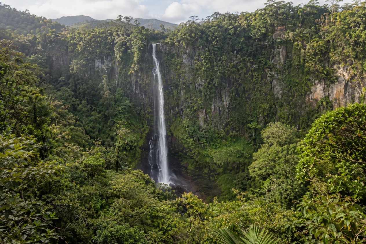
A thin white thread of water drops out of the green wall of the Cayo highlands, and the forest around it carries the screech of scarlet macaws and the smell of wet limestone. Thousand Foot Falls is a place you look at from a distance, across a gulf of treetops and rising mist. It suits travelers who like a wild landscape, a big view and a bit of effort on the way to it.
Is visiting Thousand Foot Falls worth it?
Yes, if you come for the scale of the landscape and the feeling of standing at the edge of protected forest, and less so if you want a waterfall you can walk up to and photograph from the base. The falls are believed to be the tallest in Central America, at 1,600 feet or taller, and that height is the whole point of the visit. You see a long ribbon of water against a dark cliff, and your eye keeps climbing it.
What sets it apart from the other waterfalls of Cayo is the way you meet it. Big Rock Falls and Hidden Valley Falls, both in the nearby Mountain Pine Ridge, are waterfalls you go to in order to be beside the water.
Thousand Foot Falls is a viewpoint experience first, with a full-on close approach reserved for those ready for a demanding hike through thick, mountainous forest. The place is also a protected national monument, so the mood is closer to a nature reserve than to a roadside attraction.
It pairs well with the rest of the highlands, where pine forest, rivers and caves fill out a day or two. Treat the falls as one stop in that landscape rather than the only reason for the journey, and you will likely leave happier.
What to see at Thousand Foot Falls
The visit has three parts: the outlook, the deep forest below it, and the protected land that holds everything together. Each gives a different sense of the falls.
The outlook
The classic way to see the falls is from the outlook, which sits about 0.5 miles from the water. From there you look across a deep forested valley and see roughly the top third of the cascade, where the water leaves the rim and starts its long fall.
Even a partial view is striking, because the drop is so long that the stream turns to spray before it reaches the trees. Watch for the way the light moves across the cliff face and the way the falling water thins into a veil. Binoculars are a natural companion here, though what you bring is your own call.
The pool at the foot of the falls
A closer look from the pool at the bottom takes several challenging hours of hiking through thickly forested, mountainous terrain. This is a serious outing and a different kind of day from the outlook, with steep ground, dense canopy and a sense of being far from everything.
At the pool you are looking up at the full height of the falls, and the scale feels very different from the view across the valley. Climbing to the top of the falls is strongly discouraged because it is dangerous, so keep your ambitions at the base.
The wildlife of the monument
The forest around the falls shelters endangered species, among them the scarlet macaw, the jaguar, Baird’s tapir and the orange-breasted falcon. You are unlikely to meet the big cats and the tapir, which are secretive animals, but their presence explains why this land is protected.
Scarlet macaws are the ones travelers sometimes spot, a flash of red, yellow and blue over the canopy, often heard before they are seen. The raptors are worth a glance at the sky too. Listen as much as you look, since the forest announces its residents long before it shows them.
A small national monument with a large job
Thousand Foot Falls National Monument was set aside in 2004 to protect the ecological system around the falls, and it covers 1,290 acres, which makes it one of the smallest protected areas in the country. Belize Karst Habitat Conservation, a nongovernmental organization, manages it together with the government.
Karst means limestone country, a landscape of sinkholes, caves and underground rivers, and it is the reason the highlands of Cayo are so full of caverns and falls. Knowing that makes the view across the valley more interesting, because the same rock shapes the cliffs, the water and the caves in the area.
Hours, tickets and rules
The visit centers on the outlook for most travelers and on a long hike for the few who go down to the pool. The table gives the two ways of seeing the falls and what each shows.
| Site | Distance from the falls | What you see |
|---|---|---|
| Outlook | About 0.5 miles (0.80 km) | About the top third of the falls |
| Pool at the bottom | Several challenging hours of hiking | The falls from below |
The rules the monument is known for are plain. Climbing to the top of the falls is strongly discouraged because it is dangerous. Beyond that, the sensible approach is to treat the monument as the protected area that it is, home to endangered species and managed by a conservation organization.
How to get to Thousand Foot Falls
You reach the falls through the Mountain Pine Ridge uplands, a roughly 400-square-kilometer forest reserve in the Cayo District. It is a landscape of pine forest, granite and rivers, and the Macal River forms its western and southern boundaries. The reserve is estimated to cover 106,352.5 acres, and the elevation averages between 400 and 700 meters, so the road climbs into cooler, more open country than the lowlands.
The park roads in Mountain Pine Ridge are unpaved and are not served by any real bus service. There are no real services anywhere within the reserve, although the lodges usually provide phone and internet for guests. In practice, that means planning the day around where you sleep before you set out, and arriving with what you need.
Staying in the highlands puts you at the edge of the forest rather than at the end of a long day on the road. Staying in the area puts you at the edge of the forest rather than at the end of a long day on the road. The elevation matters too, with the highest point of the reserve at Baldy Beacon, 1,017 meters above sea level, which gives the whole area its distinct, airy feel.
When to visit Thousand Foot Falls
The highlands have a rainy season from July to February and a dry season from February to May. For a waterfall this matters: the wet months feed the streams, so the ribbon of water tends to be fuller, while the dry months give clearer, sunnier days for the view across the valley. Both have their appeal, and the choice depends on whether you prefer a stronger cascade or a clearer sky.
In the dry season the temperature in the reserve may reach 102°F, which is worth remembering if you are thinking about the long hike to the pool. On a hot day, steep forest trails ask a lot of a walker. The wet months bring their own challenge, since the unpaved roads of the area are part of the journey.
A traveler who wants the thick green of the forest and a full-looking fall may lean toward the rainy months, and one who wants open views and warm sun may prefer the dry ones. In either case, the outlook gives you the fall at a good distance.
Tips for your visit
Think of the falls as part of a wider day in the highlands. The Mountain Pine Ridge is full of other natural stops: Big Rock Falls on Privassion Creek, Hidden Valley Falls, the Rio Frio Cave with the largest entrance of any cave in Belize, and the large river cave at Barton Creek, which may extend up to 4.5 miles. Together they make a landscape of water, stone and pine.
If you head for Big Rock Falls, plan to start home well before sunset, because the hike out can be steep. The same attitude suits the whole region: aim to be out of the forest while the light is still good, and leave room in the schedule for the unpaved roads.
For travelers who do not want the demanding hike to the pool, the outlook is the natural choice. The trip to the pool is demanding, with several hours of hiking in steep, thickly forested terrain, and it suits experienced walkers. Since there are no real services within the reserve, bring what you need for the day and use your lodge as your base.
Keep an eye and an ear on the forest, where scarlet macaws, falcons and perhaps other wildlife may make an appearance. Move quietly, and the place rewards you with sights that no postcard captures.
Good to know before you go
The U.S. State Department rates Belize Level 2, “Exercise increased caution”, because of crime, and says the south side of Belize City has historically had the highest concentration of violent crime.
The Atlantic hurricane season runs from June 1 to November 30, and the heavier rain of the wet months in the highlands overlaps with it, so keep your plans flexible. Inside the reserve there are no real services, so lodges are your link to phone and internet. Plan your day so that you are out of the forest in good light, and treat the monument with the care that a home for jaguars, tapirs and macaws deserves.
Sources
- Wikipedia, Thousand Foot Falls (https://en.wikipedia.org/wiki/Thousand_Foot_Falls), checked October 11, 2026
- Wikipedia, Mountain Pine Ridge Forest Reserve (https://en.wikipedia.org/wiki/Mountain_Pine_Ridge_Forest_Reserve), checked October 11, 2026
- Wikivoyage, Mountain Pine Ridge (https://en.wikivoyage.org/wiki/Mountain_Pine_Ridge), checked October 11, 2026
- U.S. Department of State, Belize Travel Advisory, Level 2, March 11, 2026 (https://travel.state.gov/), checked October 11, 2026
- NOAA National Hurricane Center, Climatology (https://www.nhc.noaa.gov/climo/), checked October 11, 2026