
THE AZORES · THE SAFETY FILE · MID-ATLANTIC
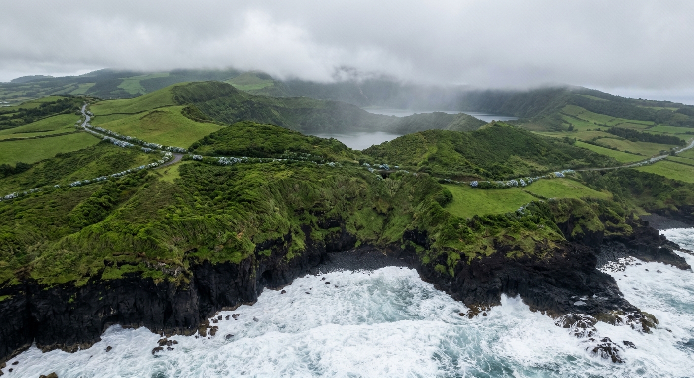
Most travelers land at Ponta Delgada braced for the wrong hazard. These islands are a small, quiet corner of Portugal, and the thing that ends a trip early is almost never another person. It is the Atlantic doing what an open ocean does, a slope of volcanic soil after rain, and a crater road that vanishes into cloud fifteen minutes above a sunlit harbor.
Scale explains much of it. São Miguel is 62.1 km long and 15.8 km at its widest, 744.7 square kilometers in all, rising to 1,105 m at Pico da Vara. One afternoon can run from a July sea averaging 73.1°F to a ridge in wind and cloud. A caveat before anything else: every air-temperature and rainfall figure here comes from IPMA station 513, Ponta Delgada Observatório, a real thermometer at 35.0 m on the south coast. The high interior is colder and far wetter than that reading.
THE SAFETY PICTURE · THE AZORES
Nothing on São Miguel is aiming at you: the risks that matter are the open Atlantic, wet ground on the crater rims, and roads that take far longer than the map suggests.
OPEN ATLANTIC SWELL · CRATER-RIM CLOUD · NORMALS MEASURED AT PONTA DELGADA, 35.0 M
Go for: a destination where the safety work is physical and predictable: read the swell before you take the ladder, watch the cloud on the rim, add time to every drive.
Think twice before: booking a boat with a small child. The official recommendation is a minimum age of five, and a sea an adult calls calm can be hard on a five-year-old for three hours.
Normals: IPMA station 513 · Sea: Open-Meteo marine averages · Boats and cetaceans: Visit Azores · full sources at the end
On this page
- Swimming and sea conditions in the AzoresSwell, ladders and water at 63.3°F
- Fog and mud on the crater-rim trailsSete Cidades and Lagoa do Fogo
- Driving times and fog on São Miguel62.1 km that is not an hour
- The emergency number in PortugalOne number for police, fire and ambulance
- Crime and theft for touristsPonta Delgada after dark
- What to pack for wet trailsThe Portugal packing list
Tram pickpocketing, ATM habits and rental paperwork belong to the national picture, and they sit with Portugal safety and the car guide. The archipelago adds three of its own: water, weather on high ground, and distance that behaves nothing like the map.
Is the sea safe in the Azores?
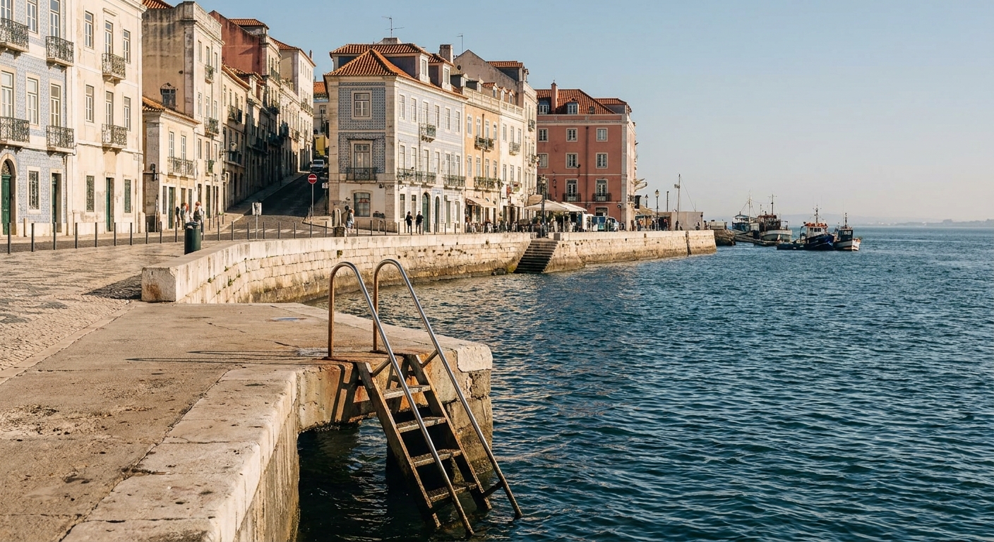
There is no gentle shelf softening the approach. Swell arrives across open ocean, and a good deal of the island’s swimming happens off concrete platforms with a steel ladder into deep water rather than off sand you can wade back up. The ladder is the whole calculation: getting in is easy on almost any day, getting out depends on what the surge is doing that minute. Temperature is rarely the deterrent people expect, since the sea off the islands averages 63.3°F in January and 73.1°F in July, measured as the mean of daily maxima.
Operators call off mornings more often than visitors anticipate, and that judgment is worth borrowing. Whale and dolphin trips run all year, a trip out lasts about three hours, and the recommended minimum age is five for exactly the reason above. When a skipper cancels, the swell that stopped the boat is the same swell working every rock shelf and every ladder on that side of the island, whatever the sky looks like from the marina.
From the rocks, the list of things not to try stays short. Do not jump into water you have not watched for several minutes. Do not swim out of a sheltered natural pool toward open water because it looks flat from above. And keep your back off the sea while someone takes the photograph on a wet basalt shelf, which is the classic way people get caught out on any Atlantic coast.
Hiking safety in the Azores: fog and trail conditions
Cloud does not roll onto these ridges so much as form on them. The set pieces sit precisely where that happens: the twin Green and Blue lakes of Sete Cidades from the Vista do Rei lookout, and Lagoa do Fogo, higher and wilder. Fifteen minutes is enough to turn a rim path with the whole caldera in view into a white corridor with a drop on one side. Turning back costs nothing on a walk that was never the entire point of the day.
Rain leaves the second problem behind it. January averages 4.02 inches at the coastal station, with 13.0 days recording at least 1 mm and 3.2 days recording 10 mm or more; July falls to 1.02 inches across 4.8 days. Those thresholds are IPMA’s own, not the 0.10-inch threshold American tables use, so the two counts do not swap. On volcanic soil under trees, a wet spell makes the surface closer to grease than mud, and the descent is where people go down.
Routes are waymarked and graded, and a grade speaks to technical difficulty rather than to what the week’s weather has done to the ground. Closures after heavy rain are the part that changes and the part that matters. We could not read the regional tourism portal on September 8, 2026, because it refuses automated reading, so we publish no closure list: read the board at the trailhead, or ask your host the evening before.
Even for two hours out, the kit is the same. A waterproof shell rather than a fleece, shoes with real tread, water, a charged phone, and a headlamp in winter, when January 15 holds about 9 hours 53 minutes of daylight and a north-facing slope loses its light well before the coast does. The country-wide layering advice lives in our packing guide.
Driving on São Miguel: fog and road conditions
Cloud parks on the crest roads for hours, which is how a drive up to Vista do Rei begins in sunshine and finishes with the hood of the car as the horizon. Low beams, never high beams into fog, and no stopping on the road itself: the lookouts have pull-ins and the next one is rarely far. Dropping down the far side often returns you to a bright coast within a few minutes.
Distance is the other thing that misleads. São Miguel measures 62.1 km end to end, which reads like an hour and drives like considerably more once the road is climbing switchbacks between Furnas, the north-coast tea plantations at Gorreana and Porto Formoso, and Lagoa do Fogo. Two anchors a day, not five. Our three-day plan pairs them realistically, and the car guide covers the rental terms that apply nationwide.
The emergency number in the Azores
A single number covers police, fire and ambulance throughout Portugal, islands included, and it is the one thing worth having in your phone before you leave the hotel. We will not print it from recall here: it sits with its source on the Portugal safety page. Save it before you drive out toward Lagoa do Fogo or start a rim walk, and tell someone not with you where you are going and when you plan to be back.
Crime in the Azores: is it safe for tourists?
Straight answer: we hold no crime statistics for the archipelago, and we are not going to invent a picture of what happens most. What can be said without numbers is what the place is. Ponta Delgada is a small port capital, in the role since 1546, and its evening version is people walking home along the marina. The ordinary trailhead habit still applies as it would anywhere, luggage out of sight in a parked car included.
The national layer really is a different animal. Crowded-tram pickpocketing, taxi and ATM habits, and the paperwork questions are handled for Lisbon and Porto conditions in Portugal safety, and those crowds have no equivalent out here. If you are combining the islands with the mainland, read that page for the mainland half of the trip.
One last thing, before the practical part. The geology is visible and long-running: an earthquake destroyed Vila Franca do Campo in 1522, which is how Ponta Delgada inherited the capital, and today’s visitor-facing version of that heat is the fumaroles and carbonated springs of the Furnas valley. As for the wildlife, these waters are one of the largest whale sanctuaries on earth, with more than 20 cetacean species, roughly a third of all that exist, and swimming with the resident common and bottlenose dolphins is permitted and regulated.
Sources & data for this guide
- Air temperature, rainfall and rain-day counts · IPMA 1991-2020 normals, station 513 Ponta Delgada Observatório, altitude 35.0 m · checked Sep 10, 2026
- Sea surface 63.3°F January and 73.1°F July, mean of daily maxima 2015-2024 · Open-Meteo Marine API · checked Sep 10, 2026
- Daylight of 9 h 53 min on January 15 · sunrise-sunset.org · checked Sep 10, 2026
- Island dimensions, Pico da Vara at 1,105 m, Ponta Delgada capital since 1546, Vila Franca do Campo 1522 · Visit Azores, São Miguel page · checked Sep 10, 2026
- Three-hour trips, recommended minimum age five, sanctuary and 20-plus cetacean species · Visit Azores, Whale Watching page · checked Sep 10, 2026
- Reserve · turismo.azores.gov.pt returned 403 to our automated reads on Sep 8, 2026, so trail classifications and current closures were not verified here: ask at the trailhead board or through your accommodation.
- The emergency number is carried, with its source, on our Portugal safety page rather than repeated from memory here.
- Sea, trail and road judgments are editorial observations, not measurements · conditions change by the hour on high ground.