
From the Goldbelt Tram in Juneau, the cabin lifts away from the cruise docks and climbs through dripping rainforest until the Gastineau Channel opens out below. In Ketchikan, the scene is quieter and made of cedar, where totem poles stand in the damp woods at Totem Bight and the rain feels like part of the setting. Both are Southeast Alaska towns of water, spruce and Tlingit heritage, and the choice comes down to a glacier and a capital city on one side, or totem poles and a salmon-canning waterfront on the other.
Which is better, Juneau or Ketchikan?
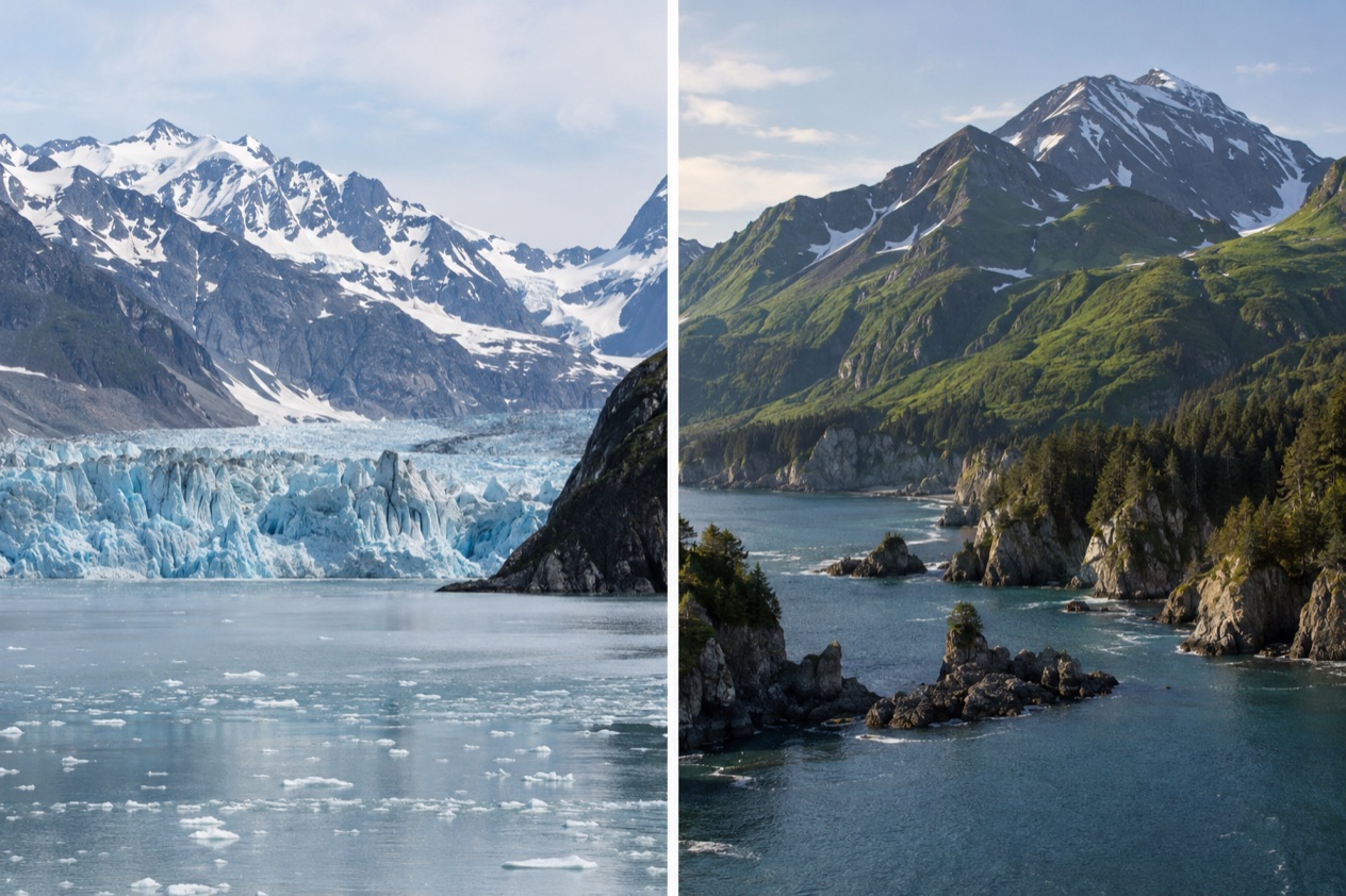
Juneau suits travelers who want a glacier, mountain trails and a chance at big wildlife close to a working capital city, while Ketchikan suits those who care more about totem poles, fishing history and a waterfront you can wander on foot. Neither one is the better town in general. They answer different questions about Southeast Alaska.
Juneau is a government town with a gold-rush past, a brewery and a hotel bar that has outlasted a century of winters. Ketchikan began as a Tlingit fish camp and grew into the self-styled Canned Salmon Capital of the World, and that cannery and logging past still colors its museums and its streets.
In Juneau you reach for the outdoors from the edge of town. In Ketchikan the town itself, with its totem collections and its island setting, is the main event.
| Category | Juneau | Ketchikan |
|---|---|---|
| Scenery | Mendenhall Glacier, ice cap, Mount Roberts, Gastineau Channel | Rainforest and sea around an island town, Deer Mountain, Misty Fjords National Monument |
| Vibe | State capital with gold-rush history and a busy cruise waterfront | Fishing and cannery town shaped by Tlingit, Haida and Tsimshian culture |
| Things to do | Glacier visit, tram, Glacier Gardens, trails, wildlife tours | Totem parks, Tongass Historical Museum, walkable downtown, Misty Fjords |
| Wildlife | Bears, bald eagles and humpback whales are likely, especially April through November | Rainforest and water setting, with Misty Fjords as the big wild landscape |
| Weather | Cool summers, cold snowy winters, rain at some point in most stays | Nicknamed the Rain Capital of Alaska |
| Getting there | Air or sea only, airport close to downtown, ferry terminal at Auke Bay | Island town on Revillagigedo Island, airport with a runway and a seaplane area, cruise piers downtown or at Ward Cove |
| Best for | Glacier seekers, hikers, wildlife watchers, history and beer fans | Totem pole lovers, culture and history fans, anyone who likes a compact town |
Read down the columns and the pattern is clear. Juneau gives you more to do outside the town limits, and Ketchikan gives you more to see inside them.
Scenery and wildlife
Juneau sits inside the Tongass National Forest, the world’s largest temperate rainforest, and the landscape stacks up in layers behind the downtown streets. Mount Roberts rises to 3,819 feet right over the waterfront.
Behind it lies a vast ice cap that covers a huge share of the borough, and from that ice comes Mendenhall Glacier, a river of ice stretching about 13.6 miles. The glacier and its surroundings are protected as a recreation area within the national forest, so what you see is a glacier set in a forest, not a roadside curiosity.
The wildlife in Juneau is the kind visitors travel for. You are likely to see bears, bald eagles or humpback whales, especially from April through November, and tours can bring you close to black bears, Dall’s porpoises, sea lions, harbor seals, sea otters, mountain goats and Sitka blacktail deer.
These are chances, not promises, and a gray day on the water can still turn up a harbor seal on a rock or an eagle on a spruce. The town sits at 58 degrees north, so the light changes widely from one season to the next.
Ketchikan’s beauty is closer and more enclosed. The town spreads along the Tongass Narrows at the foot of Deer Mountain on Revillagigedo Island, and rainforest and sea press in from every side. Boats, floatplanes and fishing docks give the narrows a constant working motion, and the hillside above is dark green and often wrapped in cloud.
The big landscape here is Misty Fjords National Monument, which covers more than two million acres of the Tongass and is run by the U.S. Forest Service. It lies about 40 miles from town along the Inside Passage coast, a wilderness of fjords and forest.
For glaciers, mountains and the better chance of big animals, Juneau wins this round clearly. Ketchikan takes it for a feeling of being tucked inside rainforest and water, with a vast fjord wilderness on its doorstep. If one glacier is the picture you have in mind for Alaska, choose Juneau. If you imagine misty water and tall cedar, choose Ketchikan.
Things to do
Both towns fill days easily, but they do it in different ways. Juneau pulls you toward ice, trails and views, while Ketchikan pulls you toward carved wood, museum rooms and a waterfront that rewards slow walking. Food follows the same split, with beer and bar history in Juneau and a salmon-and-seafood heritage in Ketchikan.
Juneau: glacier, tram and gardens
Mendenhall Glacier is the headline, about 13 miles from downtown and only a few minutes from the airport, and you can drive directly to it. The surrounding Tongass land gives you a forest-and-ice setting, and the nearby trail network is broad, since Juneau counts more than 250 miles of hiking trails for hikers of all skill levels.
The Goldbelt Tram starts right on the cruise docks on South Franklin Street and makes a six-minute ascent through the rainforest to the Mountain House. At the top you find a restaurant, a theater, a shop and a nature center, plus trails leading both up and down Mount Roberts, and the view takes in Juneau and Gastineau Channel.
Glacier Gardens in Mendenhall Valley is a rainforest garden known for its Flower Towers, upside-down trees turned into living sculptures with cascading blooms. Its Rainforest Adventure Tours roll along a two-mile path in 18-passenger golf carts and finish at a lookout over the valley and the Chilkat Mountains. Back downtown, the Alaskan hotel and bar has been pouring for more than a century, and a glass of Alaskan beer from the local brewery is the natural pairing.
Ketchikan: totem parks, museum and Misty Fjords
Ketchikan is said to hold the world’s largest collection of standing totem poles, spread across Saxman Totem Park, Totem Bight State Park, Potlatch Park and the Totem Heritage Center. Totem Bight State Historical Park sits on the North Tongass Highway, north of the town, on a small piece of woodland where carved poles and a clan house stand among the trees. It is a place to slow down and read the carvings.
Saxman lies next to Ketchikan and is a separate town, which gives you a second chance to see poles in a community setting. In the downtown core, the Tongass Historical Museum tells the story of the people, businesses and events of the late 19th and early 20th centuries, and the cannery and logging years explain why salmon and timber shaped the town. The Ketchikan story project, an Emmy-winning series, tells the town’s tale from the beginning of time to the recent past.
Downtown Ketchikan is easy to walk, with historic buildings, galleries, shops and locally made goods lining the waterfront, and the old boardwalk streets of Creek Street climb out over the water. For a bigger outing, Misty Fjords National Monument gives you fjords and forest on a scale that the town cannot match. If the weather turns, the museum and the galleries give you a dry afternoon.
Weather and the best time to go
Juneau has a real winter and a cool summer, and rain can come in any season. Its summer afternoons stay cool, with warmer days possible, and winter temperatures average a little below freezing. The town records precipitation on 230 days of the year, so you should expect rain at some point during a stay. The table gives the airport figures for the two ends of the calendar.
| Juneau airport | Average high (°F) | Average low (°F) | Precipitation (inches) | Days with precipitation | Snowfall (inches) |
|---|---|---|---|---|---|
| January | 33.1 | 23.8 | 6.02 | 13.4 | 24.5 |
| July | 64.0 | 50.1 | 5.14 | 11.6 | 0.0 |
In practice, January means cold days around the freezing mark, a lot of snow and short winter days, with the legislature in session from January to April or May. July means cool afternoons you can spend outside in a rain jacket, and a good share of those days bring some precipitation, though often in passing showers and not all-day soaking. These are airport readings, so the glacier and the mountain tops will feel different.
Wildlife timing is the best clue for planning. Bears, bald eagles and humpback whales are likely especially from April through November, and the cruise season brings a daily rush of ships between May and September. That means the downtown waterfront is at its liveliest in those months, and it is the part of the year when you can ride the tram or visit the glacier alongside many other visitors.
Ketchikan wears its weather in its nickname, the Rain Capital of Alaska, and the town and its forest make a good deal of that dampness. A day that starts gray can break open over the Tongass Narrows and show Deer Mountain.
Both towns reward flexible plans, since much of what you do in either place, from a totem park to a museum to the garden tours, happens under cloud and in drizzle. If your priority is a long run of clear views of a glacier, Juneau in the warm months gives you more chances. If you enjoy atmosphere over views, Ketchikan’s gray days suit the place.
Getting there and getting around
Juneau cannot be reached by land, only by air or sea, and the city has no roads connecting it to the rest of Alaska or to the Lower 48. Seattle is the only direct departure city in the Lower 48, and the nonstop flight takes about 2.5 hours. From Anchorage the flight takes about 90 minutes. Because Juneau is relatively remote, travelers should plan transportation early.
Once you land, Juneau International Airport is only about 10 minutes from downtown, and its runway stretches 8,857 feet, with a separate seaplane landing area beside it. Mendenhall Glacier lies near the airport, and you can drive directly to it. The Alaska Marine Highway ferry terminal is in Auke Bay, 13.8 miles out on Glacier Highway, and ferries run regularly through Southeast Alaska.
Downtown Juneau is compact enough that the tram base sits right on the cruise docks on South Franklin Street, and the city’s urban area is only a small slice of its enormous borough. Most of the land is forest and ice, which is why sights like the glacier and the gardens in Mendenhall Valley sit apart from the waterfront.
Ketchikan lies on Revillagigedo Island, 700 miles northwest of Seattle, and is the southernmost of Alaska’s larger cities. Its airport has one asphalt runway of 7,500 feet and a water runway for seaplanes, which fits a town where floatplanes and boats are everyday transport.
Cruise ships dock in one of two main places, downtown Ketchikan or Ward Cove, about 5.5 miles from downtown. The downtown area has five possible berths, Piers 1 through 4 and Doyon Landing, which typically takes smaller overnight ships, while Ward Cove has a single pier with docking on both sides. Once you are in town, downtown is easy to walk, and Totem Bight lies farther out on the North Tongass Highway.
Who should choose which
Choose Juneau if a glacier is the picture you want to bring home, if you like trails, and if you hope to meet eagles, whales or bears from the water or the shore. It also suits people who like their travel with some civic history, since Juneau became the capital in 1906, took its name from a gold prospector, and keeps traces of the Tlingit presence going back thousands of years.
Choose Ketchikan if totem poles, Alaska Native culture and fishing history are what draw you, if you like towns you can cover on foot, and if a rainy day sounds like atmosphere instead of a problem. It is the better pick for slow museum afternoons and a long look at carved cedar, with the quiet of Misty Fjords as a bigger ambition for those who want it. The Tlingit, Haida and Tsimshian cultures are part of daily life here.
Combining them works if you want both sides of Southeast Alaska on the Inside Passage, with glacier and mountain in one stop and totem poles and rainforest in the other. Each one needs its own arrival by air or water, so treat them as two separate bases and give each enough time to feel like itself.
Good to know before you go
Both towns share their waterfronts with cruise ships. Juneau sees a daily influx of 16,000 people or more between May and September, and Ketchikan welcomes more than 800,000 cruise visitors over the course of a year.
In practice that means busy downtown sidewalks on ship days and a quieter feel once the ships pull out. Juneau’s urban area is small, so it is worth knowing that the glacier, the gardens and the ferry terminal sit well beyond the docks, while Ketchikan’s downtown galleries and shops stay within walking range of the piers.
Sources
- Travel Juneau (https://www.traveljuneau.com/), checked October 11, 2026
- Wikivoyage, Juneau (https://en.wikivoyage.org/wiki/Juneau), checked October 11, 2026
- Wikipedia, Juneau, Alaska (https://en.wikipedia.org/wiki/Juneau,_Alaska), checked October 11, 2026
- Wikipedia, Juneau International Airport (https://en.wikipedia.org/wiki/Juneau_International_Airport), checked October 11, 2026
- Goldbelt Tram, Juneau (https://mountrobertstramway.com/), checked October 11, 2026
- Glacier Gardens Rainforest Adventure, Juneau (https://www.glaciergardens.com/), checked October 11, 2026
- Wikipedia, Mendenhall Glacier (https://en.wikipedia.org/wiki/Mendenhall_Glacier), checked October 11, 2026
- Wikipedia, Mount Roberts Tramway (https://en.wikipedia.org/wiki/Mount_Roberts_Tramway), checked October 11, 2026
- Visit Ketchikan (https://www.visit-ketchikan.com/), checked October 11, 2026
- Wikivoyage, Ketchikan (https://en.wikivoyage.org/wiki/Ketchikan), checked October 11, 2026
- Wikipedia, Ketchikan, Alaska (https://en.wikipedia.org/wiki/Ketchikan,_Alaska), checked October 11, 2026
- Wikipedia, Ketchikan International Airport (https://en.wikipedia.org/wiki/Ketchikan_International_Airport), checked October 11, 2026
- Wikipedia, Misty Fjords National Monument (https://en.wikipedia.org/wiki/Misty_Fjords_National_Monument), checked October 11, 2026
- Wikipedia, Saxman, Alaska (https://en.wikipedia.org/wiki/Saxman,_Alaska), checked October 11, 2026
- Wikipedia, Totem Bight State Historical Park (https://en.wikipedia.org/wiki/Totem_Bight_State_Historical_Park), checked October 11, 2026
- NOAA NCEI, U.S. Climate Normals 1991-2020, monthly (https://www.ncei.noaa.gov/access/services/data/v1?dataset=normals-monthly-1991-2020&stations=USW00025309), station Juneau Intl Ap, elevation 16 feet, checked October 11, 2026
To plan your stay
- Best Time to Visit Juneau: Weather by Month, Wildlife Season and Cruise Crowds
- Things to Do in Juneau: Mendenhall Glacier, Mount Roberts Tram, Whale Watching and Day Trips
- Where to Stay in Juneau: Downtown, Mendenhall Valley and Auke Bay
- Juneau from Seattle: Nonstop Flight, Ferry from Bellingham and What to Do on Arrival