
The first thing you notice at Yukon-Charley Rivers National Preserve is the quiet: no engines on a road, only current against the hull and wind in short spruce. Bluffs rise straight from the brown water of the Yukon, and old log cabins sit half hidden on the banks, left by people who came for gold and furs. This is a river trip into eastern Alaska along the Canadian border, for travelers who like to be self-sufficient and move at the speed of the water.
Is visiting Yukon-Charley Rivers National Preserve worth it?
Yes, if you want a wilderness river trip with no crowds and you are ready to plan it carefully. It suits paddlers, powerboaters, backpackers and anyone who likes the idea of sleeping in a cabin that was built for the river traffic of another era.
In the preserve you will not see RVs, smell car exhaust or wait in line. There is no cell phone service and there are no amenities or services of any kind, so the experience is built entirely on what you bring with you and what the river gives you.
The preserve protects 115 miles of the historic Yukon River and the entire basin of the Charley River, a federally protected National Wild River. That pairing gives you two very different trips in one place: a long, broad river for steady floating, and a clear wilderness stream for people with serious whitewater skills. The Yukon is the gentler of the two, and visitors treat it as a multi-day journey from one small town to the next.
The reward is a sense of distance. Days pass between signs of other people, and what you do find, an old cabin, a roadhouse, a trapper’s relic, comes with a story of the Yukon as a highway long before roads reached Interior Alaska. For travelers who value that kind of solitude, the preserve is among the most rewarding places in the state.
What to see at Yukon-Charley Rivers National Preserve
The sights here are strung along the water. The attraction is the river corridor itself, its bluffs, its side creeks and the historic buildings that appear where people once stopped for the night.
The Yukon River
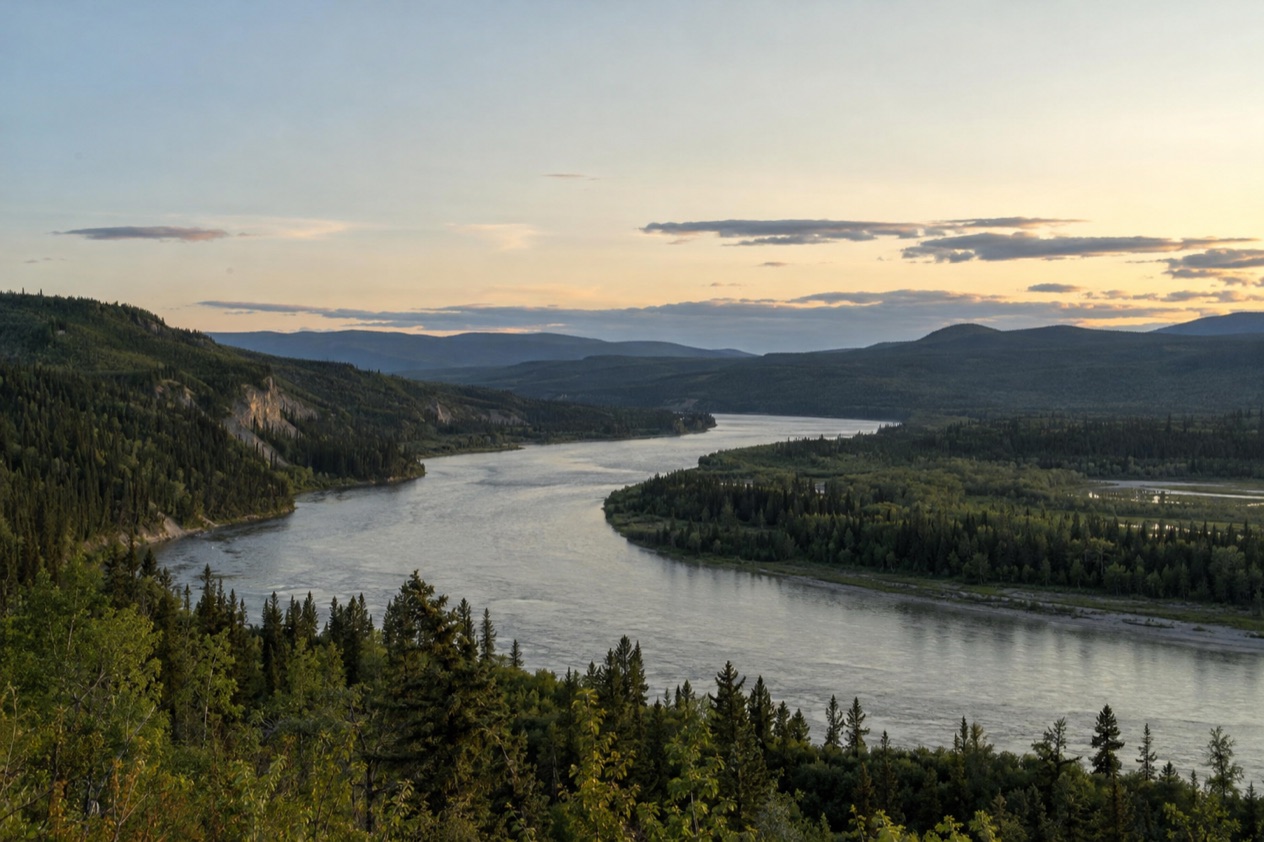
The Yukon is the main route through the preserve, and floating it by raft, canoe or powerboat is a popular way to take in the grandeur of Interior Alaska. The river is wide and slow-moving, with forested hills on both banks and rock bluffs that rise above the current. You spend your days drifting, watching the shoreline change, and looking for places to pull ashore and camp.
The most traveled trip runs from Eagle to Circle, a 158-mile route that averages about 30 miles a day, which gives you a sense of the pace. The river can be floated from May to September. Camping is permitted on any publicly owned land within the preserve, so your evenings are yours to choose, on a gravel bar or a bank with a view down the valley.
Fishing is allowed in the preserve’s waters, which adds another reason to stop and linger. Along the way, keep an eye on the bluffs and the sky, where you may spot birds of prey riding the air above the water.
The Charley River
The Charley is a different undertaking. It is a National Wild River over 100 miles long, and it demands more advanced skills than the Yukon. Most of it is rated Class II, with some Class III and even Class IV in high water, so this is a river for experienced boaters who can read rapids and handle an emergency.
The Charley can be floated from June through August. Air carriers are a necessity for anyone planning this trip, since air taxis fly in to the headwaters. Visitors can charter one from Fairbanks or Tok. The reward is a true wilderness experience, with clear water and a valley far from any road.
Historic cabins, Coal Creek and Slaven’s Roadhouse
Along the Yukon, visitors can see historic cabins and relics from bygone eras. These buildings recall the years of gold prospecting, trapping and river commerce, when the Yukon was the main way in and out of the Interior. Walking through one is a quiet history lesson, with weathered logs, low doorways and the feeling of a place that was built for survival.
In summer it serves as a bunkhouse for visitors and Park Service personnel, and each February it becomes a dog drop station during the Yukon Quest race. Coal Creek Camp is 100 miles by river from Eagle, or a 4-mile hike from the roadhouse, or you can fly into the Coal Creek airstrip.
Nation Bluff and the public use cabins
Seven public use cabins stand in the preserve, free of charge and first come, first served, with no reservation system. Nation Bluff Cabin sits 49 miles from Eagle, downstream from the mouth of the Nation River at the base of Nation Bluff. It sleeps one comfortably, or a couple sharing the bed, with a maximum of three people.
Other cabins include Glenn Creek, Kandik River, and a smaller cabin at Slaven’s. Visitors must replace the firewood they use in the wood stoves, and a GPS unit set to NAD83 datum will help you find them. Even if you do not sleep inside, a cabin makes a fine landmark on a long float.
Hours, tickets and rules
The preserve has no gate, no ticket booth and no daily hours. No entrance pass or fee is required, and no registration is needed to enter.
| Site | Open |
|---|---|
| Yukon River floating | May to September |
| Charley River floating | June through August |
| Slaven’s Roadhouse | Summer, as a bunkhouse |
| Public use cabins | First come, first served |
Camping is permitted on any publicly owned land in the preserve. Fishing is allowed in its waters, and hunting is allowed under Alaska game regulations, covering both subsistence hunting by local residents and sport hunting.
Visitors must replace the firewood they burn in cabin wood stoves, and must dispose of inedible game parts, fish and food scraps that could attract bears at least 300 yards from camp and below high water level. Groups that are nonprofit, educational, commercial or guided must contact the park several months before their travel dates for permit requirements and group size limits.
How to get to Yukon-Charley Rivers National Preserve
There is no direct highway connection to the preserve, and in summer access is limited to water or air travel. Visitors can come by air from Fairbanks, or by water or air from Eagle or Circle. Two long gravel roads lead to those towns, and from there the river or a small plane takes you in.
By road to Eagle or Circle
The Taylor Highway is 161 miles long, beginning at Tetlin Junction on the Alaska Highway and ending in Eagle. It is mostly gravel, suitable for cars, trucks and small RVs, and it is usually open from mid-April to mid-October. Visitors find that driving or flying into Eagle and floating the Yukon is the most reasonable option.
The Steese Highway begins in Fairbanks and travels 162 miles to Circle. It is also mostly gravel, and it is open year-round, depending on snow and drifting conditions in the winter months. From Circle, visitors can reach the preserve by motoring 14 miles up the Yukon River in a powerboat.
By air and by water
From Eagle, you can float down the Yukon River into the preserve, which is how most river trips begin. Air carriers can also return visitors to the put-in point. Some travelers leave their gear, boat and party in Eagle, then drive to Circle so that the vehicle is waiting at the end of the journey.
For the Charley River, an air taxi is the way in. Visitors can charter one from Fairbanks or Tok to fly into the headwaters. In winter, access is by air or by more adventurous options including snowmachines. The Visitor Center in Eagle and the Information Center in Fairbanks can help with planning.
When to visit Yukon-Charley Rivers National Preserve
The floating season is the main window, and it is set by the rivers. The Yukon can be floated from May to September, and the Charley from June through August. Those are the months when boats, bunkhouse beds and cabins are most useful to a traveler.
The Taylor Highway, one of the two gravel roads, is usually open from mid-April to mid-October, so the drive to Eagle shapes the start and end of the season. The Steese Highway to Circle is open year-round, depending on winter snow and drifting. For anyone planning around mid-October, that road timing matters before the river does.
Winter is a different preserve. Visitors can ski, mush and snowmachine through it, and dog mushing follows a historic route. Slaven’s Roadhouse becomes a dog drop station during the Yukon Quest race each February. Access in winter is by air or by adventurous options such as snowmachines, so it is a trip for experienced people with the right equipment.
People who want to travel the Yukon from its headwaters to the Bering Sea often begin planning years in advance. For a shorter trip through the preserve, the practical rule is to allow room for weather. Air taxis are often unable to fly in inclement weather, so a flexible schedule is part of any good plan.
Tips for your visit
Plan as if you are the only help available, because you are. Visitors must be self-reliant and able to execute self-extraction and communication in an emergency. With no cell phone service, a satellite phone is an excellent method of two-way communication, and one can be rented in Fairbanks before the trip.
Write a detailed trip plan and leave it with friends or family. It should say what you are doing, where you are going and what to do if you do not return by a certain date. Because air taxis are often grounded in bad weather, bring extra food and allow for weather days at the end of the trip.
Food storage and bears
Bear-resistant food containers are not required but strongly encouraged for overnight visits. They are provided free of charge at the Eagle Visitor Center and the Fairbanks Alaska Public Lands Information Center, first come, first served, with no reservations. The park provides steel drum containers with locking lids and smaller backpacker containers.
Backpacker containers are loaned for hiking, packrafting and kayaking only, while canoeists are required to use the larger steel containers provided in Eagle. If you do not use a container, cache all food and scented items at least 100 feet from camp and suspend them at least 10 feet above ground, although short spruce trees often make this difficult or impossible. Report any bear encounter by completing the Alaska Bear Encounter Report Form, and look at the park’s Bear Safety web page for more.
Planning your days
Think of the trip in terms of river stages. The Eagle to Circle float is the classic outline, with stops at historic cabins, a night at a public use cabin or a gravel-bar camp, and time for fishing. Coal Creek and Slaven’s Roadhouse make a natural pause for history. Pair the preserve with the drive to Eagle or a stay in Fairbanks, where you can pick up containers and rent a satellite phone.
Good to know before you go
There is nothing to buy at the preserve, and no entrance fee, so your costs come from getting there: gas for the gravel roads, an air taxi charter, or a boat. Carry everything you need for the trip, including food, fuel, repair gear and communication, since there are no services. Public use cabins charge no fees, and the park asks only that you replace any firewood you burn.
Sources
- National Park Service, Yukon-Charley Rivers National Preserve, plan your visit: basicinfo (https://www.nps.gov/yuch/planyourvisit/basicinfo.htm), checked October 11, 2026
- National Park Service, Yukon-Charley Rivers National Preserve, plan your visit: conditions (https://www.nps.gov/yuch/planyourvisit/conditions.htm), checked October 11, 2026
- National Park Service, Yukon-Charley Rivers National Preserve, plan your visit: directions (https://www.nps.gov/yuch/planyourvisit/directions.htm), checked October 11, 2026
- National Park Service, Yukon-Charley Rivers National Preserve, plan your visit: fees (https://www.nps.gov/yuch/planyourvisit/fees.htm), checked October 11, 2026
- National Park Service, Yukon-Charley Rivers National Preserve, plan your visit: publicusecabins (https://www.nps.gov/yuch/planyourvisit/publicusecabins.htm), checked October 11, 2026
- National Park Service, Yukon-Charley Rivers National Preserve, plan your visit: safety (https://www.nps.gov/yuch/planyourvisit/safety.htm), checked October 11, 2026
- National Park Service, Yukon-Charley Rivers National Preserve, plan your visit: things2do (https://www.nps.gov/yuch/planyourvisit/things2do.htm), checked October 11, 2026
- Wikipedia, Yukon–Charley Rivers National Preserve (https://en.wikipedia.org/wiki/Yukon–Charley_Rivers_National_Preserve), checked October 11, 2026