
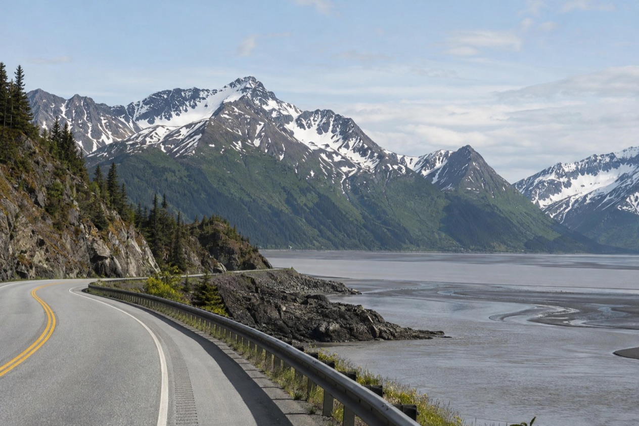
Along the Seward Highway the mountains drop straight into a wide gray-brown waterway, and at low tide the water simply disappears, leaving a shining plain of mud cut by winding channels. Pull over at a viewpoint and you may spot white shapes high on the cliffs or a pale back rolling through the current. Turnagain Arm is less a single sight than a long stretch of coast to drive, ride and stop along, with a ghost forest, a ski town and a wildlife center strung along its shore.
Is visiting Turnagain Arm worth it?
Yes, especially if you like a landscape that changes by the hour and a trip with plenty of reasons to stop. It suits drivers, train riders and cyclists heading out of Anchorage, families who want a wildlife center and a short list of easy-to-reach stops, and anyone curious about how tides and an earthquake can rewrite a shoreline.
What sets it apart from other waterways near Anchorage is the water itself. The tides here are the largest in the United States, reaching up to 40 feet, and the incoming flood often starts with a tidal bore, a moving wall of water that surfers and kayakers sometimes ride.
Nowhere else nearby do you see a bay empty into a mud flat and refill in a rush, with mountains of the Chugach Range standing directly behind. Add the story of a town that sank into the sea and a highway that was raised and rebuilt, and the arm becomes a place to read as much as to look at.
It is also a place of small, specific pleasures: a marsh boardwalk where birders hunt for rarities, cliffs where Dall sheep walk ledges that look impossible, and a trailhead in the rainforest at the end of the day.
What to see at Turnagain Arm
The tides, the bore and the mudflats
The arm runs east to west for roughly forty miles, and its size is part of the drama. At low tide it becomes a broad mud flat cut by stream channels, silty and glossy and utterly empty of boats. Then the flood returns, often led by a tidal bore that can stand up to six feet high.
The bore travels at 5 to 6 miles per hour, and it is a spectacle in its own right: a rippling line of brown water pushing up the channel while the flats go under behind it. Adventurous kayakers and surfers ride it as an extreme sport, which gives the roadside viewpoints a small crowd of onlookers on the right days.
Watch from the shoulder of the highway pullouts, and keep off the flats. Hikers along the arm are warned about quicksand-like mud that can trap a boot, and the soft, shining surface looks far more solid than it is.
Portage and its ghost forest
At the eastern tip of the arm, Portage is a ghost town. It first appeared in a census as a small village, then the great earthquake of 1964 dropped the ground so far that most of the town ended up below the high tide line. Salt water flooded the roots of the nearby trees, and they died where they stood.
What remains are the ruins of a few buildings and a gray ghost forest of bleached trunks that rises out of the marsh, one of the clearest places in Alaska to see what the earthquake did to the land. Today Portage is a junction of road and rail, where the Seward Highway and the Alaska Railroad connect to Portage Glacier park and the Anton Anderson Memorial Tunnel toward Whittier. Photographers like the trunks in flat light, when they look like a field of pale bones against the dark mountains.
Alaska Wildlife Conservation Center
The wildlife center sits at the head of the arm near the site of Portage, on a 140-acre property that lies 11 miles beyond the Girdwood turnoff. It is the most convenient stop on this stretch for seeing Alaska animals up close, and it works as a pairing with the nearby ghost forest.
The center is among the popular recreational stops of the Portage area, which also include floating the Portage, Twentymile and Placer rivers, fishing for hooligan in the Twentymile River and ice skating on the marshy areas, creeks and Portage Lake. Those pastimes change with the season, so what you do around the center depends on when you come.
Girdwood and its trails
Girdwood is the arm’s base for outdoor days. The hamlet was destroyed by subsidence and tidal action in the earthquake and relocated inland, and today it is home to Alaska’s largest ski area, the Alyeska Resort. Hotels here sit among the mountains and put you within reach of the arm and the Kenai Peninsula to the south.
The Winner Creek Trail winds through the northernmost rainforest in the United States to a thundering waterfall, and the North Face Trail climbs Mt. Alyeska. A paved six-mile bike trail runs from Alyeska Resort to Bird Point, and the Crow Creek Gold Mine, a historic mining area, is open to the public as an attraction. In summer the Veilbreaker Skybridges offer paid guided tours, weather permitting.
Cliffs, wildlife and the water’s edge
High above the arm, Dall sheep navigate the rocky cliffs of the Chugach Mountains, so a glance up from a pullout can reward you with pale specks on the ledges. An endangered population of beluga whales is commonly seen moving through the waterway with the rising and falling tides, which makes the water worth watching when the flood is running.
At Potter Marsh, birders once found a Falcated Duck, a first for the area and for the whole state of Alaska. That is the kind of surprise the marsh holds for patient watchers, though most days are quieter and more ordinary. A scenic stop that fits any pace, it is worth a pause on the way in or out of Anchorage.
Hours, tickets and rules
Turnagain Arm is a waterway and a highway corridor, so it has no gate and no single set of hours. The viewpoints, the ghost forest and the roadside stops are places you reach as you travel along the Seward Highway. What does run on a schedule are the seasonal activities in Girdwood, set out here.
| Site | Open |
|---|---|
| Veilbreaker Skybridges, Girdwood (paid guided tours, weather permitting) | Typically July to September |
| Alyeska Resort ski season, Girdwood | Late November through March, sometimes into early May |
| Summer hiking in Girdwood | June through September recommended |
The one rule that matters most on the shore is about the mud. Hikers along the arm should take care not to get stuck in the quicksand-like mudflats, and the flats are not a place to wander. The bore tide is ridden by kayakers and surfers as an extreme sport, which is something to watch from the edge rather than assume is open to everyone.
How to get to Turnagain Arm
The arm lies along the Seward Highway, which runs 125 miles from Seward to Anchorage. It is designated a National Forest Scenic Byway, a State Scenic Byway and an All-American Road, and it passes through the Kenai Peninsula, Chugach National Forest, Turnagain Arm and the Kenai Mountains. From Anchorage you meet the arm almost immediately and follow it out.
From Anchorage by car
Girdwood is the natural base, 37 miles south of Anchorage, and the drive takes about 1 hour. The main access to Girdwood is the Seward Highway, which is scenic but can be slow during peak summer travel times. The wildlife center is 11 miles beyond the Girdwood turnoff, and Portage lies 47 miles southeast of downtown Anchorage.
The stretch from Girdwood past the Portage curve is the busiest piece of the corridor, a point we come back to when planning the timing. If you enjoy a loop, the Old Seward Highway is a former routing of the highway, nearly 8 miles long and located entirely within Anchorage, with its southern end near Potter Section House.
By train and other ways
There is a train from Anchorage to Girdwood, and the ride takes about 1.5 hours. The Alaska Railroad has two trains that stop there: the Coastal Classic, which runs between Anchorage and Seward, and the Glacier Discovery, which stops in Whittier, Portage and Spencer Glacier. The Coastal Classic winds along the arm itself, where the Chugach Range plunges directly to the water, so the view from the window is part of the trip.
Red Eye Rides offers flexible, year-round transportation to and from Girdwood with local drivers. Cyclists can follow U.S. Bicycle Route 97, which runs alongside the Seward Highway along its entire length.
When to visit Turnagain Arm
Summer is the time for hiking, with June through September recommended for hikes around Girdwood. It is also the busiest on the road: in the summer months up to 15,000 vehicles use the stretch from Girdwood to beyond the Portage curve each day, so the highway can feel slow and the pullouts full.
Winter belongs to the skiers. For the best skiing at Girdwood, aim for late November through March, though the resort sometimes stays open into early May. Skiers and snowshoers also have trails to explore around Girdwood, with more than 30 miles of untracked routes. A winter drive along the arm is a different experience, with snow on the cliffs and the flats ribboned with ice.
Festivals and special weekends
Girdwood’s Slush Cup festival takes place the second weekend of April, a spring send-off for the ski season. In early July comes the Girdwood Forest Fair, held over the July 4th weekend, with Alaskan artists, handmade crafts, exotic foods and entertainers. That is also a time when the highway is at its busiest.
Timing the tide
The tide shapes the day more than the hour on the clock. At low tide the arm is a broad mud flat, and when the flood starts it often begins with a bore, so the same viewpoint offers two very different pictures.
Belugas are often seen moving with the rising and falling tides, which gives you another reason to watch the water as it turns.
Tips for your visit
Think of the arm as a line of stops rather than one destination. A good day strings together a marsh at the Anchorage end, viewpoints along the highway where you scan the cliffs for sheep and the water for belugas, a visit to Girdwood for a trail or a meal, and then the wildlife center and Portage near the end of the line. The corridor is easy to read as a story, from the sunken town to the raised highway that now carries you through it.
What to combine it with
Girdwood pairs well with the arm: the Winner Creek rainforest walk, the Alyeska mountain trails, the Crow Creek Gold Mine and, in summer, the Veilbreaker Skybridges. From Portage the road and rail junction leads on toward Portage Glacier park and the tunnel to Whittier. The Glacier Discovery train stops at Portage, Whittier and Spencer Glacier, and the Coastal Classic carries on to Seward.
The earthquake story adds a layer to the drive. About 20 miles of the Seward Highway sank below the high-water mark of the arm, and the highway and its bridges were raised and rebuilt over the following years. Looking at the flats from the roadbed, you can picture how close the water once came.
Families, cyclists and pace
The wildlife center gives families a clear anchor for the day, with animals to see in a 140-acre setting. Cyclists have the paved trail from Alyeska Resort to Bird Point, and the long route beside the highway. Birders will want to linger at Potter Marsh.
Pack layers and sturdy shoes for the trails, binoculars for the cliffs and the water, and a camera that handles distance. Keep your eyes on the mud as you walk: stay off the flats, and treat the tide line as a boundary, since the flood can return as a moving wall of water.
Good to know before you go
The arm is a place to look at carefully rather than step into. The mudflats look firm and are not, and hikers along the shore are warned about getting stuck.
Some pleasures here are seasonal, such as the skybridge tours in summer and skiing in winter, so match your plans to the months. On a busy summer day the highway between Girdwood and Portage slows down, which is a good reason to leave room in the schedule for pullouts and unplanned stops.
Sources
- Wikipedia, Turnagain Arm (https://en.wikipedia.org/wiki/Turnagain_Arm), checked October 11, 2026
- Wikipedia, Seward Highway (https://en.wikipedia.org/wiki/Seward_Highway), checked October 11, 2026
- Wikivoyage, Girdwood (https://en.wikivoyage.org/wiki/Girdwood), checked October 11, 2026
- Alaska.org, dest girdwood (https://www.alaska.org/destination/girdwood), checked October 11, 2026
- Wikipedia, Portage, Alaska (https://en.wikipedia.org/wiki/Portage,_Alaska), checked October 11, 2026
- Alaska Railroad, Coastal Classic (https://www.alaskarailroad.com/ride-a-train/our-trains/coastal-classic), checked October 11, 2026
- Visit Anchorage, wildlife viewing (https://www.anchorage.net/outdoors/wildlife-viewing/), checked October 11, 2026
- Visit Anchorage, places to stay (https://www.anchorage.net/places-to-stay/), checked October 11, 2026
- Wikipedia, 1964 Alaska earthquake (https://en.wikipedia.org/wiki/1964_Alaska_earthquake), checked October 11, 2026