
Early in the morning, buses idle near the canal while vendors set up along Haulover Creek, and the Swing Bridge still gets turned by hand to let boats pass. Belize City is where the country’s roads, boats and small planes all meet, a working port town on the Caribbean coast rather than a resort. It suits travelers who want to see how Belize actually runs, and who plan to head on to the cayes, the rainforest or the Maya sites.
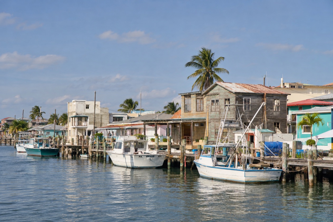
Where is Belize City and what is it like?
Belize City sits in Belize District, on the Caribbean coast, on a small peninsula that pushes into the sea at the mouth of Haulover Creek, a distributary of the Belize River. It is the largest city in the country, and it is the principal port and the financial and industrial hub. Offshore lie the islands of the district, among them Ambergris Caye, Caye Caulker, St. George’s Caye and Caye Chapel.
The city was once the capital of British Honduras. After a hurricane in 1961 flattened much of it, the government moved inland to Belmopan, a move completed in 1970.
You can still feel that history in the streets: old wooden houses, a creek that divides the center, and the sense of a place that has been rebuilt more than once.
The pace is brisk and practical. People are going to work, to the port, to the bus terminal, and the city does not dress itself up for visitors the way the cayes do.
That is its appeal for travelers curious about daily life, local food and history, and it is also why some visitors treat it as a gateway and not a base. Anyone expecting white sand and hammocks will find those offshore, not in town.
Just outside town, the district has its own surprises: wildlife sanctuaries inland and barrier islands out to sea. Belize City is the hinge between them, which makes it a useful place to understand the country’s layout even if you stay only briefly.
What is there to do in Belize City?
The reasons to come are history, the waterfront and the day trips that start here. Local dining and shopping fill out a stop, and the things that set the city apart from the cayes are its museums, its bridge and its role as the country’s main port.
The Museum of Belize and the city’s history
The Museum of Belize occupies a building that served as the city prison until 1993. It was restored and opened as a national museum in 2002, and the structure itself is part of the story. Walking through it, you move from a place of confinement to galleries of art and history.
Among the exhibits is one on slavery in Belize, with a timeline, accounts of slave revolts and the communities of escaped slaves known as maroons. It is a sober, worthwhile hour or two for anyone who wants to understand the country beyond its reefs. Pair it with a stroll along the creek to see the Swing Bridge.
| Site | Open | Admission |
|---|
The waterfront and Fort Street Tourism Village
At the mouth of Haulover Creek, on the northern bank, the Fort Street Tourism Village is the cruise visitor’s front door. It is built around several courtyards with snack bars, local stores with duty-free shopping, restaurants and live local entertainment. Ships anchor offshore and passengers come in by tender, a ride of about 15 minutes.
Even if you did not arrive by ship, the complex gives you an easy place to sit down with a drink, hear music and browse crafts near the water. It is a gentler introduction to the city than the busy streets farther in.
Day trips to the cayes and the sanctuaries
St. George’s Caye lies eight miles east of the city. It was settled as a town in 1650 and was the largest settlement in British Honduras in the 17th and 18th centuries, and Belize’s first capital in the 1700s. The Spaniards once called it Cayo Cocina, Kitchen Cay.
Small planes from the Municipal Airport reach San Pedro on Ambergris Caye and Caye Caulker, and the flight gives an aerial view of the Caribbean on the way. Inland, the district holds Crooked Tree Wildlife Sanctuary and the Community Baboon Wildlife Sanctuary, both within Belize District.
How many days do you need in Belize City?
A day or two is enough for the city itself, and most travelers pass through on the way to somewhere else. That is not a criticism, because the city rewards a short, focused look at its history and waterfront.
With a single day, see the Swing Bridge, spend time in the Museum of Belize, and sit down to a local meal. With two, add the Fort Street Tourism Village and a slow walk along the creek. These are the sights that give you the character of the city without needing more.
With more time, the city becomes a launch point. Flights from the Municipal Airport go to San Pedro and Caye Caulker, and early flights head south to Dangriga, Placencia, Savannah and Punta Gorda. Buses run west toward Belmopan and San Ignacio, and north toward Orange Walk and Corozal.
Inland, Crooked Tree Wildlife Sanctuary and the Community Baboon Wildlife Sanctuary sit within the district, and St. George’s Caye is out in the sea. A week lets you combine the city with a caye, a sanctuary and one of the inland towns, with the city serving as the place you return to between hops.
Where to stay in Belize City
The central area around Haulover Creek and the Fort Street Tourism Village is the natural choice for visitors who want to be near the waterfront, the museum and the Swing Bridge. It puts you in the middle of the city’s history and close to the cruise village, and it suits travelers who like to explore on foot during the day.
Near the Municipal Airport, about a mile outside downtown, is a practical base for anyone catching a domestic flight to the cayes or the south. Ladyville, the largest village in Belize, lies eight miles northwest of the city along the Philip Goldson Highway and has become a suburb, with many residents commuting to the city daily. It sits close to the international airport and suits travelers with an early or late flight.
Many visitors choose to sleep on the cayes instead, using Belize City only as a connection. Ambergris Caye and Caye Caulker are considered two of the country’s primary tourism areas, and both are reached from the city by air.
How do you get to Belize City and get around?
Most visitors arrive at Philip S. W. Goldson International Airport in Ladyville, which serves all international flights. It lies about 30 minutes by car (10 miles) northwest of downtown, connected by the Philip Goldson Highway. The airport’s daily opening hours run from 6:00 a.m. to 6:00 p.m., with services beyond those hours available on request, and check-in counters for all airlines are in Terminals 1 and 2.
Belize City has a second airport, the Municipal Airport (TZA), used only for domestic flights and located about a mile outside downtown. It offers travel between ten domestic destinations, and Tropic Air runs hourly flights to San Pedro on Ambergris Caye. Maya Island Air also operates from here.
By road, northbound buses to Orange Walk and Corozal leave about every half hour from 5:30 a.m. to 7:30 p.m. Westbound buses to Belmopan, San Ignacio and Benque Viejo del Carmen depart between 5 a.m. and 9 p.m.
By sea, cruise passengers arrive at the Fort Street Tourism Village, a tender port. Harvest Caye, a separate port in the south of Stann Creek District, caters only to Norwegian Cruise Line passengers and is not part of Belize City.
When is the best time to visit Belize City?
January is a pleasant month: highs reach the low 80s and nights are mild in the upper 60s, with the sea near 81°F. Rain still falls on about ten days, but it is lighter than in the heart of summer, which makes winter a comfortable season for walking the city and heading out to the cayes.
July is hotter and more humid, with highs near 89°F and warm nights, and the sea warms to the mid-80s. Rain falls on about twelve days. The heat makes it a month for slow mornings and shade in the afternoon.
The Atlantic hurricane season runs from June 1 to November 30, and Belize City has a long memory of it. Hurricane Hattie in 1961 damaged over 70% of the city’s buildings, and the airport sits only a few feet above sea level, which puts both it and the city at risk of serious flooding. The drier months outside that window are the easier choice for most travelers.
Good to know before you go
The U.S. State Department rates Belize Level 2, “Exercise increased caution”, because of crime, and says the south side of Belize City has historically had the highest concentration of violent crime.
Violent crime in Belize has historically been concentrated in the Southside of Belize City and is gang related, so most visitors stay in the central waterfront area and the tourist village. Credit card fraud rings are believed to be active in Belize, particularly in San Pedro, which is worth remembering when you head to the cayes.
The currency is the Belize dollar. Hurricane season runs from June 1 to November 30, so the weeks of early summer through autumn call for a flexible plan.
Sources
- Wikipedia, Belize City (https://en.wikipedia.org/wiki/Belize_City), checked October 11, 2026
- Wikivoyage, Belize City (https://en.wikivoyage.org/wiki/Belize_City), checked October 11, 2026
- Wikipedia, Belize District (https://en.wikipedia.org/wiki/Belize_District), checked October 11, 2026
- Wikivoyage, Belize District (https://en.wikivoyage.org/wiki/Belize_District), checked October 11, 2026
- Wikipedia, Philip S. W. Goldson International Airport (https://en.wikipedia.org/wiki/Philip_S._W._Goldson_International_Airport), checked October 11, 2026
- Belize Port Authority, Fort Street Tourism Village port (https://portauthority.bz/belize-port-facilities/fort-street-tourism-village-port/), checked October 11, 2026
- Belize Tourism Board, Cruise licensing (https://www.belizetourismboard.org/licensing/cruise/), checked October 11, 2026
- Wikipedia, Ladyville (https://en.wikipedia.org/wiki/Ladyville), checked October 11, 2026
- Wikipedia, Museum of Belize (https://en.wikipedia.org/wiki/Museum_of_Belize), checked October 11, 2026
- Wikipedia, Hurricane Hattie (https://en.wikipedia.org/wiki/Hurricane_Hattie), checked October 11, 2026
- Philip S. W. Goldson International Airport (Belize), Quick facts (https://www.pgiabelize.com/passenger-info/quick-facts/), checked October 11, 2026
- Tropic Air, Belize City municipal airport (https://www.tropicair.com/belize-city-tza/), checked October 11, 2026
- Maya Island Air, Belize City flights (https://www.mayaislandair.com/belize-city-flights/), checked October 11, 2026
- Wikipedia, St. George's Caye (https://en.wikipedia.org/wiki/St._George's_Caye), checked October 11, 2026
- Wikipedia, Climate of Belize (https://en.wikipedia.org/wiki/Climate_of_Belize), checked October 11, 2026
- NOAA NCEI, GHCN-Daily station BHM00078583 (Philip S. W. Goldson International Airport, Belize City), normals 1991-2020 computed from the daily record (https://www.ncei.noaa.gov/access/services/data/v1?dataset=daily-summaries&stations=BHM00078583), checked October 11, 2026
- Open-Meteo Marine API, average 2015-2024, checked October 11, 2026
- U.S. Department of State, Belize Travel Information, Safety and security (https://travel.state.gov/), checked October 11, 2026
- U.S. Department of State, Belize Travel Advisory, Level 2, March 11, 2026 (https://travel.state.gov/), checked October 11, 2026
- NOAA National Hurricane Center, Climatology (https://www.nhc.noaa.gov/climo/), checked October 11, 2026
All our pages
When to go
- Best Time to Visit Belize City: Weather by Month, Hurricane Season and What to Do
- Belize City in January: Weather, Sea Temperature, George Price Day and Things to Do
- Belize City in February: Weather, the Sea, Museum Visits and a Two-Day Plan
- Belize City in March: Weather, the Sea, National Heroes Day and a Two-Day Plan
- Belize City in April: Weather, Warm Sea, Museum Visits and a Two-Day Plan
- Belize City in May: Weather, Sea Temperatures, Things to Do and a Two-Day Plan
- Belize City in June: Weather, the Sea, Things to Do and a Two-Day Plan
- Belize City in July: Weather, Warm Sea, Museum Visits and a Two-Day Plan
- Belize City in August: Weather, Warm Seas and What to Do
- Belize City in September: National Celebrations, Weather and What to Do
- Belize City in October: Weather, the Sea, Things to Do and a Two-Day Plan
- Belize City in November: Garifuna Settlement Day, Weather and What to Do
- Belize City in December: Weather, the Sea, Things to Do and a Two-Day Plan
Things to do
- Things to Do in Belize City: Museum of Belize, Nearby Cayes, Day Trips and Local Food
- Day Trips from Belize City: Altun Ha, the Belize Zoo, St. George's Caye and Lamanai
- 3 Days in Belize City: Museum of Belize, St. George's Caye and an Island Day by Air
Where to stay
- Where to Stay in Belize City: Haulover Creek, Ladyville, the Cayes and Hotel Taxes
- Belize Airport to Belize City Hotels: Rental Cars, the Airport Road, Terminals and Fees
Getting there
- Belize City from the United States: Flights, the Airport Transfer and Water Taxis to the Cayes
- Belize Airport to Caye Caulker: Flights, the Water Taxi and Rental Cars
- Belize Airport to Hopkins: Rental Cars, the Travel Desk, Roadwork and the Drive Beyond Dangriga
- Belize Airport to Placencia: Domestic Flights, Rental Cars and the Road Out of Ladyville
- Belize Airport to San Ignacio: Rental Cars, the Road West and Arriving at BZE
- Belize Airport to San Pedro: Getting to Belize City, the Ferry and Rental Cars
- Belize City to Caye Caulker: Water Taxi, Flights and What to Expect on the Island
- Belize City to Placencia: Flights, Ground Options and the Peninsula at the End
- Belize City to San Ignacio: Buses, Driving and the Road West
- Belize City to San Pedro: Water Taxi, Flights and What Awaits on Ambergris Caye