
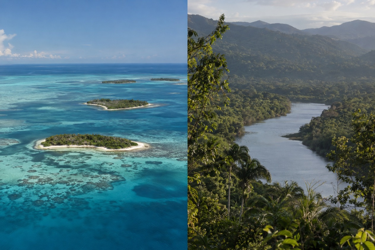
In Placencia, the day drifts along a concrete Sidewalk lined with small businesses until the path simply runs out at the edge of the sea. In Hopkins, the evening belongs to Garifuna drums, with the Maya Mountains darkening behind the village and the Caribbean in front of it. Both are small villages on the southern coast of Belize, and the choice between them comes down to whether you want a reef-and-boat base or a Garifuna village with forest at its back.
Which is better, Placencia or Hopkins?
Neither is a big resort town, and that is part of why people compare them. They are two different answers to the same wish: a quiet stretch of southern Belize coast.
Placencia sits at the southern tip of a long, narrow peninsula, with the sea on one side and the lagoon country behind. Hopkins looks the other way, toward the Maya Mountains and the Cockscomb Range, and lies very close to the Sittee River. That difference in setting shapes almost everything else, from what you do in the morning to what you eat at night.
| Category | Placencia | Hopkins |
|---|---|---|
| Setting | Southern tip of the Placencia Peninsula, sea at the end of the Sidewalk | On the Caribbean shore, with the Maya Mountains and Cockscomb Range inland |
| Vibe | A tourist village with businesses along a pedestrian path | A Garifuna village, with the river and forest close by |
| Reef and marine life | Barrier reef, Laughing Bird Caye and whale shark waters off the coast | Reef trips are not described for Hopkins itself |
| Nature inland | Peninsula settlements and lagoon country | Sittee River, mountains and the Cockscomb Range |
| Culture | Peninsula villages including Garifuna Seine Bight | Garifuna majority, drumming and music |
| Best for | Reef days, snorkeling and diving trips, a walkable village | Garifuna culture, river and mountain scenery |
If you cannot decide, ask yourself where you want to be at dawn. A Placencia morning tends to start with a boat toward the reef. A Hopkins morning starts with the village, the river and the hills.
Beaches and the sea
Placencia is a village built around its shoreline. The Sidewalk, a pedestrian-only concrete path, runs most of the length of the village and ends at the seashore, so the sea is never far from wherever you are staying.
Cafés, shops, small restaurants and tour offices line the path, and the walk to the water is part of the daily rhythm. Beyond the village, the peninsula carries a string of other settlements, among them Seine Bight, Maya Beach Village and Riversdale, each with its own stretch of coast.
What sets Placencia’s sea apart is what lies beyond the shore. The longest barrier reef in the northern hemisphere is a short boat ride off the coast, and Laughing Bird Caye, a national park and World Heritage Site, sits closer still.
For many visitors the beach is the starting point and the reef is the reason. You come back from a day on the water to sand, a cold drink and a table by the sea.
Hopkins faces the Caribbean too, and its shore is the front edge of a village that sits between sea and mountains. The village was founded in 1942 to replace Newtown, which a hurricane had devastated further up the coast, and its layout still feels like a place built along a single seafront.
Here the beach is a village beach: boats, nets, children, evening walks. The Sittee River nearby adds a second kind of water to the picture, brown and slow against the blue of the sea.
Sargassum is a matter for the Belize Tourism Board to describe, and it can reach Caribbean shores. We will not promise any beach clear of it, in either village. The same goes for conditions in the water, which change with the season and the day. Plan on the beach being a pleasant part of the trip, and plan the reef or river as the main event.
Who wins? For a trip built around the sea, Placencia, because the reef, the caye and the marine reserve all begin from its shore. For a trip where the shore is one chapter among river, forest and village life, Hopkins. That is a difference of purpose, not of quality, and plenty of travelers would be happy in either.
Things to do
The two villages offer very different menus. Hopkins leans toward culture and inland nature, with Garifuna music, rivers and the national parks of the Stann Creek hills. Food is good on both sides, built on seafood, rice and beans, coconut and the cooking of the Garifuna and Creole kitchens.
Reef, caye and whale sharks from Placencia
Laughing Bird Caye is 12 miles off the coast of Placencia village, a very small island protected as a national park since 1991. It is the kind of place people go to for snorkeling and diving, and the barrier reef itself is a 45-minute boat ride from the village. Gladden Spit and Silk Cayes Marine Reserve lies farther out and protects a spawning site, the Silk Cayes and the whale sharks that gather there.
Between March and June, around the full moon, whale sharks pass by Gladden Spit, and visitors can dive or snorkel with them at the snapper spawning site on the reef. It is a chance, not a promise, and arranging your place ahead is advised. The reserve is managed by the Southern Environmental Association, a community-based organization, and it is worth knowing that the whale shark zone has had special protection since 2001.
Village life in Placencia
Back on land, the village itself is the activity. Placencia is listed by the Guinness World Book of Records for the narrowest main street in the world, which is the Sidewalk you will walk up and down several times a day.
Evenings mean seafood plates, a drink in a beach bar and a stroll past the shops. Seine Bight, a Garifuna village just up the peninsula, adds another side of the area and a place to hear the Garifuna language.
Nightlife here is of the relaxed, village kind: a few bars, music some evenings, and early nights after a day on the water. Nobody comes to Placencia for a club scene, and it is better for it.
Garifuna culture and the hills around Hopkins
Hopkins is a village where the Garifuna are the large majority, and the culture is the main attraction. UNESCO recognized the language, dance and music of the Garifuna as a Masterpiece of the Oral and Intangible Heritage of Humanity.
Drumming and punta rhythms are the sound of a Hopkins evening, and Garifuna dishes such as hudut, fish in coconut broth with plantain, are the taste of it. Garifuna Settlement Day, a public holiday on November 19, is the big occasion across the Garifuna communities of Belize.
Behind the village, the Maya Mountains and the Cockscomb Range raise the possibility of a day in the forest. Cockscomb Basin Wildlife Sanctuary, off the Southern Highway, was established as the first protected area for the jaguar and is recognized as the world’s first jaguar preserve.
Mayflower Bocawina National Park, also on the Southern Highway, is another green stop in the Stann Creek District. Dangriga, known as the culture capital of Belize for its punta music and other Garifuna traditions, is the district capital where traditional Garifuna dancers can be seen.
Weather and the best time to go
The seasons in southern Belize come as a wetter stretch and a drier one, with hurricane season layered over the calendar. Placencia and Hopkins share the same Caribbean coast and the same broad pattern, so the question is less which village has better weather and more which month suits the trip you want. The reef and the whale sharks have their own timetable, and the hills care little for it.
| Month | Belize City high (°F) | Belize City low (°F) | Belize City rain (inches) | Belize City rain days |
|---|---|---|---|---|
| January | 83.2 | 68.0 | 4.97 | 10.3 |
| July | 89.3 | 77.0 | 5.73 | 11.8 |
In Belize City, January is the milder of the two months, with warm days and cooler nights, while July is hot and humid with warmer nights. Rain falls on roughly the same number of days in both months, so you pack for a shower whichever you pick. January suits long days outside, and July suits those who like heat and the green of the season.
For Placencia, the whale shark window is the seasonal draw. It runs from spring into early summer, when the fish gather around the full moon at Gladden Spit. If seeing them is the point of the trip, plan around that and around the moon, and treat the sighting as a chance.
The Atlantic hurricane season runs from June 1 to November 30. A trip in those months overlaps with it, and southern Belize has a real history.
When Hurricane Iris struck southern Belize on October 8, 2001, with 145 mph winds, it badly damaged nearly 95% of the buildings in Placencia. Hopkins has its own story too: the village exists because a hurricane devastated Newtown further up the coast, and the village was created to replace it in 1942.
If you want the sea and the reef at the center of the trip, spring and the early part of summer line up with the whale sharks. If you want the hills and the river, the Maya Mountains look their best when the forest has had its rain. They simply offer different things at different moments.
Getting there and getting around
Placencia can be reached by air. Dangriga Airport, also known as the Pelican Beach Airstrip, is served by Maya Island Air and Tropic Air several times daily, with flights to Belize City, Placencia and Punta Gorda. That makes the southern coast a place you can hop along by small plane as well as by road.
By road, the Hummingbird Highway is the main route to Dangriga from Belmopan, known for its scenic beauty as it cuts through the Belizean mountains. The highway is completely paved along its 49-mile length. The Southern Highway then carries traffic past the entrances to parks such as Mayflower Bocawina and Cockscomb Basin, so a road trip along the Stann Creek District doubles as a nature itinerary.
Once you are in Placencia village, the Sidewalk is the main thoroughfare. It is a pedestrian-only concrete path that runs most of the length of the village and ends at the sea, so the village center is a place you cross on foot. The peninsula is long, with Riversdale Village, Maya Beach Village, Seine Bight and Placencia Village strung from north to south, and the settlements are distinct places rather than one continuous town.
Hopkins is a village on the Caribbean shore, with the Maya Mountains and the Cockscomb Range inland and the Sittee River very close. The village is small, and its life is centered on the shore, the roads of the village and the nearby river. Excursions to Cockscomb Basin Wildlife Sanctuary, Mayflower Bocawina National Park and the Garifuna town of Dangriga make up the usual day plans from the area.
A boat is the way to the reef from Placencia. The barrier reef is a 45-minute ride off the coast, and Laughing Bird Caye is closer than that. Gladden Spit and Silk Cayes Marine Reserve lies 22 miles off the coast, which is why whale shark outings are a dedicated trip rather than a stop on a casual afternoon.
Who should choose which
Choose Placencia if the reef is why you are going. The barrier reef, Laughing Bird Caye and the Gladden Spit whale sharks all start from its shore, and the village around them is made for it: the Sidewalk, the shops, the restaurants, the small bars.
It suits couples, friends and divers who want a base where the day ends with a table by the sea. It also suits anyone who likes to walk from breakfast to the boat dock without needing a plan.
Choose Hopkins if the people and the place are why you are going. Seventy percent of the village is Garifuna, and the music, the language and the food are close to the surface of daily life.
It suits travelers who want drumming in the evening, the river and mountains by day, and the national parks of the Stann Creek hills within reach. It is a quieter, more rooted choice, and the village is not trying to be anything else.
Combining the two is natural in southern Belize, because both sit in the same stretch of coast and the same corner of the country. A few days in Hopkins for the Garifuna culture and the forest, then a few in Placencia for the reef, gives you both halves of the area. The small planes of the Dangriga airstrip, which fly to Placencia, are one way the two ends of the region connect, and the Southern Highway is the other.
Whale sharks and the barrier reef point to Placencia. Garifuna culture and the mountains point to Hopkins. Either way you leave with a very different memory of southern Belize.
Good to know before you go
The U.S. State Department rates Belize Level 2, “Exercise increased caution”, because of crime, and says the south side of Belize City has historically had the highest concentration of violent crime.
Both villages sit on the Atlantic side, so a trip between the start of June and the end of November overlaps with hurricane season, and it is sensible to follow the forecast before and during your stay. Fees at the national parks and wildlife sanctuaries are set by the bodies that manage them, and Cockscomb Basin Wildlife Sanctuary, run by the Belize Forest Department and the Belize Audubon Society, publishes its own entrance fees.
| Fee | Amount | Who pays |
|---|---|---|
| Cockscomb Basin Wildlife Sanctuary entrance | BZD 10 | Non-nationals |
| Cockscomb Basin Wildlife Sanctuary entrance | BZD 2.50 | Belizean nationals |
Sources
- Wikipedia, Placencia (https://en.wikipedia.org/wiki/Placencia), checked October 11, 2026
- Wikivoyage, Placencia (https://en.wikivoyage.org/wiki/Placencia), checked October 11, 2026
- Wikipedia, Seine Bight (https://en.wikipedia.org/wiki/Seine_Bight), checked October 11, 2026
- Belize Fisheries Department, Gladden Spit and Silk Cayes Marine Reserve (https://fisheries.gov.bz/gsscmr/), checked October 11, 2026
- Wikipedia, Gladden Spit and Silk Cayes Marine Reserve (https://en.wikipedia.org/wiki/Gladden_Spit_and_Silk_Cayes_Marine_Reserve), checked October 11, 2026
- Wikipedia, Silk Cayes (https://en.wikipedia.org/wiki/Silk_Cayes), checked October 11, 2026
- Wikipedia, Laughing Bird Caye (https://en.wikipedia.org/wiki/Laughing_Bird_Caye), checked October 11, 2026
- Tropic Air, Placencia (https://www.tropicair.com/placencia-plj/), checked October 11, 2026
- Wikipedia, Hopkins, Belize (https://en.wikipedia.org/wiki/Hopkins,_Belize), checked October 11, 2026
- Wikipedia, Dangriga (https://en.wikipedia.org/wiki/Dangriga), checked October 11, 2026
- Wikivoyage, Dangriga (https://en.wikivoyage.org/wiki/Dangriga), checked October 11, 2026
- Wikipedia, Cockscomb Basin Wildlife Sanctuary (https://en.wikipedia.org/wiki/Cockscomb_Basin_Wildlife_Sanctuary), checked October 11, 2026
- Belize Audubon Society, Cockscomb Basin Wildlife Sanctuary (https://belizeaudubon.org/cbws/), checked October 11, 2026
- Wikipedia, Garifuna (https://en.wikipedia.org/wiki/Garifuna), checked October 11, 2026
- Wikipedia, Mayflower Bocawina National Park (https://en.wikipedia.org/wiki/Mayflower_Bocawina_National_Park), checked October 11, 2026
- NOAA NCEI, GHCN-Daily station BHM00078583 (Philip S. W. Goldson International Airport, Belize City), normals 1991-2020 computed from the daily record (https://www.ncei.noaa.gov/access/services/data/v1?dataset=daily-summaries&stations=BHM00078583), checked October 11, 2026
- U.S. Department of State, Belize Travel Advisory, Level 2, March 11, 2026 (https://travel.state.gov/), checked October 11, 2026
- NOAA National Hurricane Center, Climatology (https://www.nhc.noaa.gov/climo/), checked October 11, 2026
To plan your stay
- Best Time to Visit Placencia: Dry Season, Whale Sharks, Sea Temperatures and Hurricane Months
- Things to Do in Placencia: Reef Days, Whale Sharks, Garifuna Culture and Where to Eat
- Where to Stay in Placencia: The Village, Seine Bight, Beachfront Resorts and How to Choose
- Placencia from Belize City: Flights, Rental Cars and What Waits on the Peninsula