
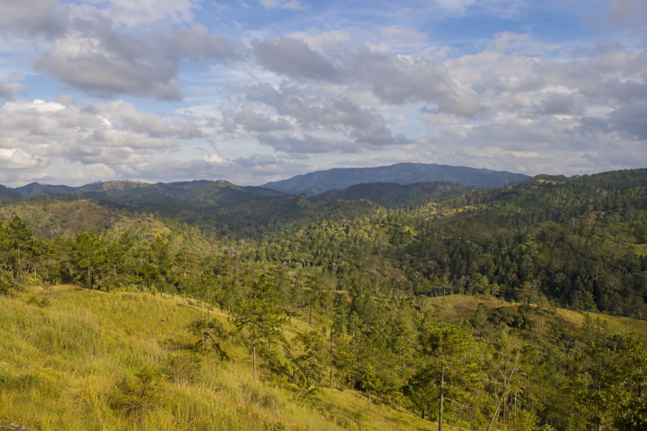
The road climbs out of the green lowlands of the Cayo District and, somewhere along the way, the broadleaf jungle gives way to open stands of tall pine, with red earth underfoot and a resinous smell in the air. Rivers run clear over granite, and the sky feels wider than it does down in the valley. Mountain Pine Ridge is a forest reserve for waterfalls, caves and quiet hours among the trees, and it rewards travelers who like to wander.
Is visiting Mountain Pine Ridge worth it?
Yes, if you like landscapes that look nothing like the rest of Belize: pine woods, cool rivers, big falls and cave mouths, with lodges tucked among them. It suits travelers staying around San Ignacio who want a day or more of scenery rather than a checklist of ruins, and anyone who is happy to leave a paved road behind.
The reserve was set aside to protect and manage the native Belizean pine forests, and that forest is what sets it apart from the jungle sites and river valleys nearby. The terrain rises in rolling ridges, the Macal River marks its western and southern edges, and the highest point, Baldy Beacon, tops the reserve.
It is large, with no real services inside it, so the visit is about space and quiet. Lodges within the reserve usually provide phone and internet for guests, which tells you a lot about the mood: you come here to be a little removed.
If you like waking up to birdsong in the pines and the sound of a creek, a night or two at a lodge here changes the rhythm of a Cayo stay.
What to see at Mountain Pine Ridge
Big Rock Falls
Big Rock Falls drops about 150 feet on Privassion Creek, also called Privassion River, and it is the larger of the reserve’s waterfalls. The water spills over dark rock into a pool below, framed by pine and broadleaf forest, and the roar carries a long way up the trail before you see anything.
Plan your time around the hike out. Hikers are advised to head home well before sunset because the climb back can be steep, so treat this as a daylight visit and leave yourself margin.
Hidden Valley Falls
Hidden Valley Falls is another of the reserve’s waterfalls, and it adds a second kind of view to the ridge: a long ribbon of water against the green, seen across the open landscape rather than from deep in a gorge. It makes a natural pairing with the pine scenery on the way in.
Photographers like it for the way the light plays on the water and the surrounding trees. Pair it with a slow drive along the unpaved park roads, stopping where the forest opens onto long views, and you get a good sense of how big the reserve really is.
Rio Frio Cave and Barton Creek
Two caves give the reserve its underground side. The Rio Frio Cave has the largest entrance of any cave in Belize, a huge arch that frames the forest light and makes you feel small. A river passes through, and the cool air at the mouth is a welcome change on a hot day.
At Barton Creek there is a large river cave that may extend up to 4.5 miles. Its scale is what stays with you, along with the way water has carved the limestone over a very long time. Both caves are about atmosphere and geology, a different Belize from the reefs and ruins.
The pine ridges and Baldy Beacon
The elevation here averages between 400 and 700 meters (about 1,312 to 2,296 feet), and Baldy Beacon rises to 1,017 meters (3,336 feet). Down along the Macal River the land falls to its lowest point, around 394 feet. That spread of elevation is why you pass from river valley to pine savanna in a single outing.
Look for the tall pines standing apart across open ground, the red soil, and the long views that make the ridge feel like a different country. This is the heart of what the reserve protects.
Hours, tickets and rules
Mountain Pine Ridge is a forest reserve rather than a single gated attraction, so there is no one entrance with posted hours. The places inside it keep their own arrangements, and the one hour set for visitors that the lodges state is the check-in and check-out at Blancaneaux Lodge.
| Site | Open |
|---|---|
| Blancaneaux Lodge (check-in) | 3 PM |
| Blancaneaux Lodge (check-out) | Noon |
One rule applies at Big Rock Falls: hikers should head home well before sunset because the hike out can be steep. The park roads are unpaved, and there is no real bus service on them. No real services are available anywhere within the reserve.
How to get to Mountain Pine Ridge
Mountain Pine Ridge sits in the Cayo District, and the Macal River forms its boundary to the west and south. The roads inside are unpaved, and no real bus service reaches them, so getting around depends on arranging your own way in rather than on public transit.
Lodges in the reserve, such as Blancaneaux Lodge, are the natural bases for time on the ridge, and they usually provide phone and internet for guests, which helps with planning the last stretch. Once inside the reserve, expect to move between sights on those unpaved roads, with the waterfalls and caves spread across a large area. Because there are no real services anywhere in the reserve, arrive with what you need for the day, and keep the unpaved surface in mind when you decide how much ground to cover.
When to visit Mountain Pine Ridge
The rainy season runs from July to February, and the dry season from February to May. The dry months are the time when the roads and trails are easiest to enjoy, and the reserve’s open pine country feels bright and spacious.
In the dry season, temperatures may reach 102°F, so start early and keep water close. The wet months bring fuller waterfalls and a greener look to the forest, and the unpaved roads are the thing to think about when you plan the day. The Atlantic hurricane season runs from June 1 to November 30, which overlaps much of the rainy season.
Whatever the month, aim to reach the waterfalls with daylight to spare. Big Rock Falls in particular calls for a return well before sunset, and the long drive out on unpaved roads is a good reason to leave the ridge while the light is still good.
Tips for your visit
Bring water, sun protection and shoes with good grip for wet rock, along with anything you want to eat, since there are no real services inside the reserve. A camera is worth carrying for the falls and the long pine vistas.
A lodge such as Blancaneaux, with check-in at 3 PM and check-out at noon, makes a good base for slowing down, and lodges usually provide phone and internet for guests.
Combine the ridge with the sights of the Cayo District: the waterfalls and caves on one day, with time in San Ignacio on another. Families and anyone with limited mobility should note that the hike out from Big Rock Falls can be steep, and that the roads are unpaved.
Good to know before you go
The U.S. State Department rates Belize Level 2, “Exercise increased caution”, because of crime, and says the south side of Belize City has historically had the highest concentration of violent crime.
The reserve covers roughly 430 square kilometers, and nothing within it works like a town, so carry what you need and keep a daylight margin on every outing. The Atlantic hurricane season runs through the end of November, so plan with the weather in mind if you visit then.
Sources
- Wikipedia, Mountain Pine Ridge Forest Reserve (https://en.wikipedia.org/wiki/Mountain_Pine_Ridge_Forest_Reserve), checked October 11, 2026
- Wikivoyage, Mountain Pine Ridge (https://en.wikivoyage.org/wiki/Mountain_Pine_Ridge), checked October 11, 2026
- Wikipedia, Big Rock Falls (https://en.wikipedia.org/wiki/Big_Rock_Falls), checked October 11, 2026
- U.S. Department of State, Belize Travel Advisory, Level 2, March 11, 2026 (https://travel.state.gov/), checked October 11, 2026
- NOAA National Hurricane Center, Climatology (https://www.nhc.noaa.gov/climo/), checked October 11, 2026