
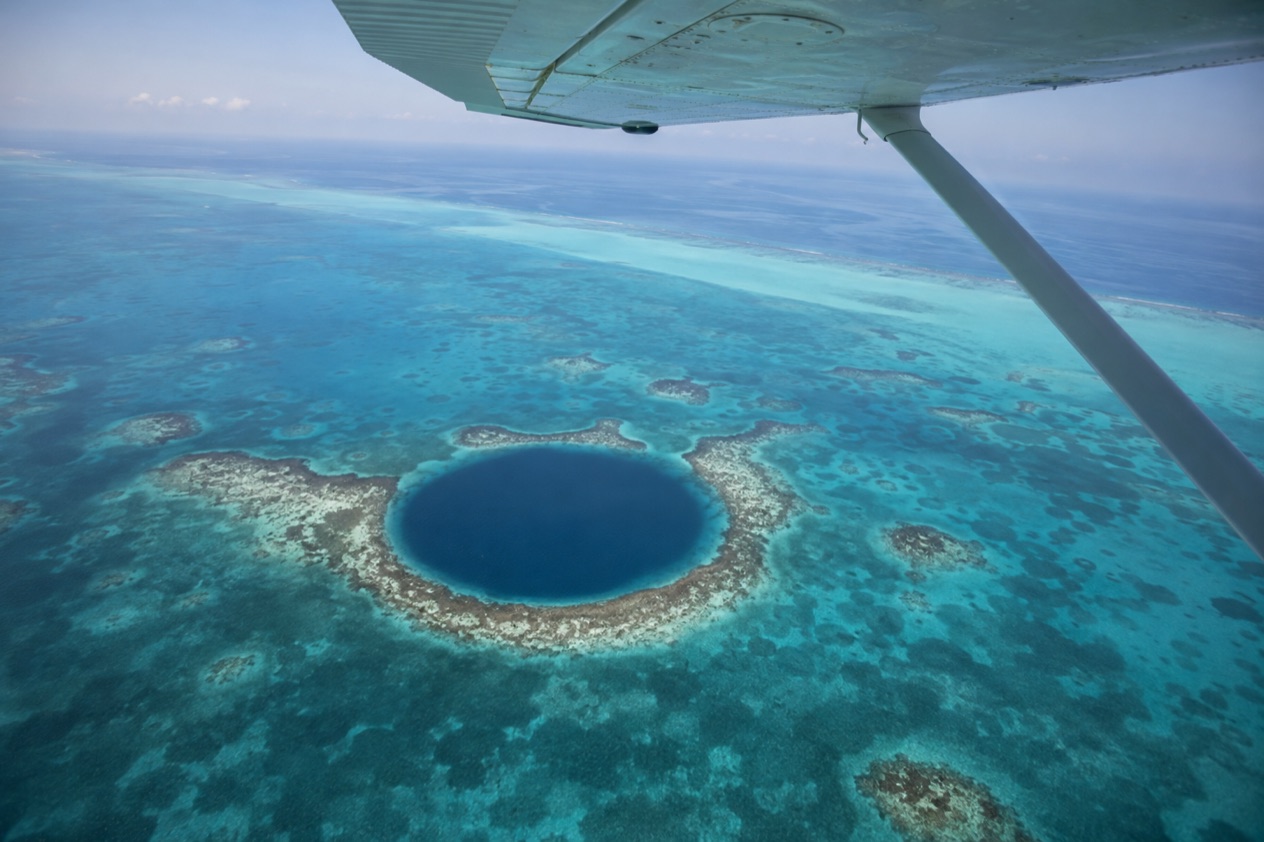
The small plane banks over the shallows, and the water below shifts from pale turquoise to a deep, inky blue so round it looks drawn with a compass. That perfect dark eye in the middle of Lighthouse Reef is the Great Blue Hole, and from the air you see its whole shape at once. A flyover is a sightseeing visit built around that single view, with the reef, the atolls and the cayes laid out on the way.
Is visiting the Great Blue Hole flyover worth it?
Yes, if what you want is to understand the Great Blue Hole as a place rather than a dive site, and to see it without getting into the water. Seen from the window of a small plane, the sinkhole reads as a clean circle of deep blue ringed by a pale band of shallow reef, and no boat or snorkel mask can give you that outline. The flight suits travelers who love maps, photographers, families with children old enough to sit by a window, and anyone whose time in Belize is built around the cayes rather than the rainforest.
What sets the flyover apart from the other ways to meet the Blue Hole is the scale. The Blue Hole Natural Monument itself includes no land and has no visitor facilities beyond mooring buoys for dive boats, and its primary focus is diving the sinkhole. Down on the surface you see a patch of dark water and a few boats.
Up in the air you see the sinkhole, the atoll around it and the long line of the barrier reef beyond. Discovery Channel ranked the Great Blue Hole first on its list of The 10 Most Amazing Places on Earth in 2012, and the aerial view is the one that explains why.
The route passes over Shark Ray Alley, Turneffe Atoll and a freighter wreck before reaching Lighthouse Reef, so the Blue Hole arrives as the climax of a long, slow look at the reef system. It is a lot of scenery from one seat.
A flyover is not a swim, a dive or a walk on a beach. You do not set foot on the atoll, and the sights come to you through a window. If you want to touch the water, you would pair the flight with time on a caye. If you want the view and the story, this is the way to get both.
What to see at the Great Blue Hole flyover
The Great Blue Hole itself
The sinkhole is almost perfectly circular, about 1,043 feet across, and it sits near the center of Lighthouse Reef. The color is the first thing you notice. A ring of bright turquoise reef edge frames a core that turns navy and then almost black, and the contrast is sharpest when the sun stands high over the water.
The tour circles the hole twice, with turns for the port side and the starboard side of the plane, so passengers on both sides get a turn at the best view. Keep a hand free for the camera and watch the rim, where the reef drops from shallow ledges into a near-vertical wall. Non-flash cameras are allowed on the tour, and the window glass is the thing to mind more than the settings.
Geologists describe the Blue Hole as a karst limestone formation, a cave that formed when the sea was far lower and collapsed as the water rose. It is believed to be over 150,000 years old, and the stalactites hanging inside record the long dry stages of its history.
Divers have found that below about 300 feet a layer of hydrogen sulfide turns the water dark and lifeless. You will not see any of that from above, but it gives the deep blue a meaning.
The barrier reef and Shark Ray Alley
Early in the flight you cross the barrier reef, the long line where the sea changes from the shallow, sandy-bottomed lagoon to open water. From the air you see the white of breaking surf along the crest and the patchwork of coral heads, sand and seagrass inside it. The Belize Barrier Reef Reserve System is a UNESCO World Heritage Site, and the Blue Hole is part of it.
Shark Ray Alley is on the route as well. On the ground it is a shallow spot where nurse sharks and stingrays gather around boats, and from above it is a quiet patch of sand and clear water in the reef.
Turneffe Atoll and the freighter wreck
Turneffe Atoll is a large ring of mangrove islets and shallows, and the plane gives you a good sense of its outline. Pale sand flats, dark patches of seagrass and the green tangle of mangroves make a mosaic that changes with every minute of the flight. Several resorts sit on Turneffe, and tour operators from the atoll also run trips to the Blue Hole.
The route also passes an ocean freighter wreck, a rusting hull resting on the reef. It is one of those sights that makes the flight feel like a real survey of the sea. Wrecks on reefs are reminders of how much of this coast is open water and how shallow the reef crest can be. Tell the person in the next seat to look as soon as you spot it, because it passes quickly.
Lighthouse Reef and its marine life
Lighthouse Reef is a small atoll about 43 miles from the mainland and Belize City, and the Blue Hole sits near its center. From above you see the atoll as a loose ring of reef around a shallow lagoon, with the dark circle of the sinkhole set in the middle like a pupil.
What you cannot see from the plane is the life around the rim. The edge of the Blue Hole supports coral and tropical fish, including groupers, squirrelfish, angelfish, butterflyfish and midnight parrotfish.
Nurse sharks, Caribbean reef sharks and blacktip sharks live there, and divers sometimes meet great hammerhead, lemon and bull sharks. Green, hawksbill and loggerhead turtles are also reported by divers and snorkelers. A flyover gives the setting for all of this, and the rest is for another kind of trip.
Hours, tickets and rules
The flyover runs as a scheduled tour in the morning on four days of the week, with another scheduled tour in the afternoon and private flights available across the middle of the day. The dive and snorkel side of the Blue Hole is run through the Blue Hole Natural Monument, which has its own hours and entrance fee for visitors arriving by boat.
| Site | Open | Admission |
|---|---|---|
| Blue Hole Natural Monument | 8:00am to 4:30pm | BZ$2.50 for nationals, BZ$60 for non-nationals |
A few rules are stated for the flight and the site. Passengers on the Great Blue Hole tour may carry only one small carry-on bag, and non-flash cameras are allowed. All Blue Hole tours with Tropic Air are weather dependent, so inclement weather may lead to rescheduling or cancellation.
At the monument, mariners must contact the Half Moon Caye park rangers on VHF Channel 16 before hitching onto a mooring or anchoring. The monument includes no land, and the only facilities are mooring buoys provided for dive boats.
How to get to the Great Blue Hole flyover
You reach the flyover from one of three starting points: Belize City, Caye Caulker or San Pedro. The scheduled morning tour leaves Belize City at 8:30am, Caye Caulker at 8:45am and San Pedro at 9:00am, on Sunday, Monday, Wednesday and Friday. The three departures share a single flight, so you join it at whichever of the three stops is closest to where you are staying.
A second scheduled tour departs at 1PM from San Pedro, Caye Caulker or Belize City Municipal. Private Great Blue Hole tours can leave from any of these stations between 10am and 2pm, which is the window suggested for the best viewing, and a private charter can be extended to give you more time at the Blue Hole for photography.
If you are on Ambergris Caye, the departure from San Pedro is the one to pick. If you are staying on Caye Caulker, the plane stops there as well. Travelers based in Belize City can board at the Belize City departure. The Blue Hole lies about 43 miles from the mainland, so the route is entirely over the sea and the reef.
Travelers who want to be on the water instead go by boat. Tour operators to the Blue Hole Natural Monument depart from San Pedro, Caye Caulker, Hopkins and Placencia, and from resorts on Turneffe and Lighthouse Reef. Visitors to the monument generally include both the Blue Hole and Half Moon Caye in their itineraries.
When to visit the Great Blue Hole flyover
The time of day matters more than anything for the view. The suggested window for private flights is between 10am and 2pm, when the sun is high enough to light the water and bring out the contrast between the turquoise rim and the dark center. That is also why the afternoon scheduled departure is a good choice for photographers, while the morning flights suit people who like to have the rest of the day free.
The scheduled morning flights run on only four days a week, so the day you choose shapes your plans. If your days on the cayes are flexible, build the flight around those mornings and keep the other days for snorkeling, fishing, a beach afternoon or a walk through town. If you are tied to a particular day, the private option gives the most room to fit your schedule.
Weather decides whether the plane flies. Tours with Tropic Air may be rescheduled or canceled in inclement weather, and the Atlantic hurricane season runs from June 1 to November 30, so a flight in those months sits inside it. A day with a spare slot in your itinerary gives you somewhere to land if a flight moves.
Other things to think about are light and sea color. On a clear day the sea around the atoll shows many shades, from the near-white of sand flats to the dark blue of deep water. Cloud shadows can make it look patchy, which is a pleasure in itself, and a day with more cloud still gives you the shape of the hole.
Tips for your visit
Travel light. Passengers may carry only one small carry-on bag, so leave the beach tote and the tripod at the hotel and bring a camera that fits in your hands. Non-flash cameras are allowed. A phone works too, though it helps to wipe the lens before boarding, since fingerprints show up badly through a window.
Think about your seat. The tour circles the Blue Hole twice, once for each side of the plane, so a window on either side gives you a good look. Take the window if you can, and if you are traveling as a group, agree before the turns that everyone will get a chance to look at the sinkhole at the same time.
For families, the flight suits children who like looking out of the window and who can sit still in a small seat. It is a fine way to give them a sense of the geography, with reef, atolls and open sea in one sweep. A child who gets restless will still enjoy the reef and the blue, so keep a snack and a drink for after landing.
Combine the flight with something on the water. If you start from San Pedro or Caye Caulker, a snorkel or a quiet afternoon on the beach makes a good counterpoint to the view from above.
The flyover passes over Shark Ray Alley, and a boat trip to see the sharks and rays up close turns that glimpse into a real memory. Divers can add the Blue Hole itself from a boat, with Half Moon Caye as the usual companion stop.
Finally, keep the day loose. Flights are weather dependent, and the Blue Hole rewards a relaxed visitor more than a rushed one. Leave room before and after, have a reserve morning and enjoy the cayes around it.
Good to know before you go
The U.S. State Department rates Belize Level 2, “Exercise increased caution”, because of crime, and says the south side of Belize City has historically had the highest concentration of violent crime.
Belize has its own currency, the Belize dollar, and the entrance fee for the Blue Hole Natural Monument is quoted in it, so keep that in mind if you plan to visit the monument by boat as well. October sits inside the Atlantic hurricane season, which runs through the end of November, and a tropical system can ground flights or reroute boats. As in any busy place, use ordinary travel habits with your belongings, and give yourself a calm start on the day of the flight.
Sources
- Maya Island Air, Great Blue Hole tour (https://www.mayaislandair.com/the-great-blue-hole-tour/), checked October 11, 2026
- Tropic Air, Great Blue Hole tour (https://www.tropicair.com/tropic-air-tours/the-great-blue-hole-tour/), checked October 11, 2026
- Wikipedia, Great Blue Hole (https://en.wikipedia.org/wiki/Great_Blue_Hole), checked October 11, 2026
- Belize Audubon Society, Blue Hole Natural Monument (https://belizeaudubon.org/bhnm/), checked October 11, 2026
- Philip S. W. Goldson International Airport (Belize), Quick facts (https://www.pgiabelize.com/passenger-info/quick-facts/), checked October 11, 2026
- Philip S. W. Goldson International Airport (Belize), Arrival and departure (https://www.pgiabelize.com/arrival-departure/), checked October 11, 2026
- Wikipedia, Roatan (Honduras) (https://en.wikipedia.org/wiki/Roat%C3%A1n), checked October 11, 2026
- Wikivoyage, Costa Rica (https://en.wikivoyage.org/wiki/Costa_Rica), checked October 11, 2026
- U.S. Department of State, Belize Travel Advisory, Level 2, March 11, 2026 (https://travel.state.gov/), checked October 11, 2026
- NOAA National Hurricane Center, Climatology (https://www.nhc.noaa.gov/climo/), checked October 11, 2026