
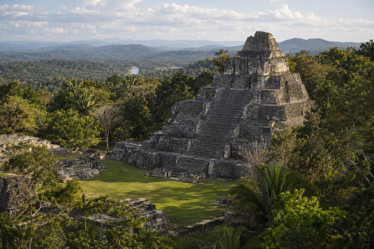
The road ends in forest, and then the trees open onto a wide grassy plaza with a pyramid standing over it. Ocellated turkeys pick across the grass, howler monkeys may be calling from somewhere in the canopy, and the stone looks far older than the jungle growing around it. Caracol is Belize’s great Maya city in the Cayo District, a place for travelers who want to spend a day among ruins that still feel half swallowed by the forest.
Is visiting Caracol worth it?
Yes, if you like your ruins large, quiet and surrounded by real forest, and you don’t mind that reaching them takes effort. Caracol is the largest known Maya archaeological site in Belize, and in the Classic Period the city spread across roughly 55 square miles. What you walk through today is only the center of that sprawl, yet it is enough to feel the scale of a place that once rivaled the biggest cities of the Maya world.
What sets it apart from other sites in the area is its remoteness. Caracol sits deep in the Chiquibul Forest Reserve, in a remote area near the Guatemala border, on the Vaca Plateau in the foothills of the Maya Mountains.
Xunantunich and Cahal Pech are close to San Ignacio and have a more town-edge feel. Caracol asks for a longer journey and rewards it with space, birdsong and a pyramid that remains the tallest man-made structure in the country.
It suits history lovers, birders and anyone who enjoys walking between monuments under a forest roof. The fitness level required for the tour is moderate to good, so it is better for people who are comfortable on rugged ground than for those wanting a brief stop between meals.
What to see at Caracol
Caana, the Sky Place
Caana, sometimes written Caanam and translated as Sky Place, is the great temple-palace complex that dominates the site. It rises about 141 feet above the plaza and is the tallest man-made structure in Belize. The mass of it is the first thing you notice from the plaza, a stepped hillside of stone with terraces, temples and palace rooms stacked on top of each other.
Its upper levels are known for sweeping views over the forest canopy, a reminder of how the rulers of Caracol watched over their city and the land around it. Look at the stonework on the lower terraces, the staircases and the small rooms on the platforms, and imagine the whole thing plastered and painted. Use the handrails where they are provided, and keep in mind that jumping on monuments is not permitted.
The carved stelae and altars
Caracol holds 53 carved stone monuments, made up of stelae (upright slabs) and round altars. Many stand at the foot of temples and in the plazas, where rulers once set them up to record victories, anniversaries and royal lineages in hieroglyphs and portraits. Some are weathered almost smooth, while others still show faces, headdresses and glyph blocks if the light falls across them at the right angle.
These texts are a big reason Caracol matters to scholars. They tell of alliances and wars, including the city’s celebrated rivalry with Tikal in the Classic Period. Take your time at each one and look for the small details, a hand holding a staff, a feathered costume, a captive at the ruler’s feet.
The site museum and the visitor center
Near the entrance, the visitor center and the monument museum give you the background before you set out. The Caracol Site Museum opened in 1999, and it helps to see the story laid out before you meet the ruins themselves: how the city grew, who ruled it and how the stones were found.
The site was first reported in 1937 by a logger named Rosa Mai, who was searching for mahogany trees when he came across the remains. In 1991 the government declared the Caracol area a national park. It is a good place to learn how a place lost in the forest became a protected site.
A royal tomb and a very long history
Researchers have found a royal tomb believed to belong to Te’ Kab Chaak, the founder of Caracol’s ruling dynasty around AD 331. The area was occupied as early as 1200 BC, and the epicentral area was lived in until no later than AD 950. That is a very long span, and it makes the plazas you cross feel like layers of history rather than a single moment.
Along the trails between the plazas, forest takes over again. Ocellated turkeys are frequently seen around the site, their blue heads and spotted tails easy to pick out against the grass. Stay on the demarcated trails, and you will likely meet birds and other wildlife along the way.
Hours, tickets and rules
Caracol is open every day, including Sundays and public and bank holidays, and the schedule is built around morning arrivals. The last guided tour of the day leaves in the early afternoon, and everyone should be ready to leave the site by midafternoon. Admission is charged in Belize dollars and depends on the type of ticket and the age of the visitor.
| Site | Open | Admission |
|---|---|---|
| Caracol | Daily, 8:00 am to 5:00 pm (last tour 2:00 pm, depart site by 3:00 pm) | BZ$15.00 to BZ$25.00, depending on ticket type and age |
Visitors must wear outdoor-appropriate footwear for the rugged terrain and stay on the demarcated trails. No loud noise, shouting or music is allowed, and across Belize’s archaeological reserves shouting, whistling, singing and clapping are prohibited. A maximum of 15 visitors is allowed per tour guide.
Smoking and starting fires are prohibited, as are alcohol, drugs, camping, and hunting or feeding wildlife. Pets must be on a leash, and coolers stay at the parking lot and the picnic areas. Visitors may not remove any plant, stone, earth or pottery, and it is illegal to buy anything claimed to have come from an archaeological site.
How to get to Caracol
You reach Caracol by road, and the road is part of the experience. The only route to the site leads off the Western Highway between San Ignacio and Belmopan, and also connects with Santa Elena. The last 9.9 miles are paved, which makes the journey easier than older guidebooks suggest. The access road from the Mountain Pine Ridge area is also now paved.
Caracol lies in the Cayo District, south of Xunantunich and San Ignacio, and San Ignacio is the town most visitors use as a base. The site is deep in the Chiquibul Forest Reserve, on the Vaca Plateau, so expect to leave the busier parts of Cayo well behind. Many excursions to Caracol are organized from the area, and they often fold the ruins into a longer outing through the Mountain Pine Ridge.
Because the site is remote, plan your day around the opening and tour times, with the last tour at 2:00 pm and departure from the site by 3:00 pm. On the return you can combine Caracol with other stops.
Many excursions pair it with Rio On Pools or Big Rock Falls in the Mountain Pine Ridge, so the day ends at the water after the ruins. Parking is available at the site for those arriving on their own.
In the rainy months the final stretch can be harder going, since heavy showers can make roads difficult. The dry months are when road conditions are usually at their easiest. Remember that the site sits at about 1,600 feet above sea level, so the air under the trees can feel a little different from the lowlands you started in.
When to visit Caracol
The dry season, from about February through May, is when road conditions are usually easiest and rain falls less often. For a site reached by a long forest road and explored on foot, that is a real advantage. The trails are firmer, the plazas are drier, and the climb up the stairways is more comfortable underfoot.
The rainy season generally lasts from June through November or December, with heavy afternoon showers that can make trails muddy and roads difficult. The forest is at its greenest then, and the ruins look dramatic against dark clouds. If you come in these months, pack raingear and good footwear, and let the weather shape your pace.
As for the time of day, the site opens in the morning, and an early start fits the schedule well, since the last tour goes in the early afternoon and the site empties by midafternoon. Morning light on the plaza is a pleasure for photographs, and you get more time in the shade of the forest trails before you leave. Caracol is open every day, including holidays, so a holiday does not close the gates.
There is no festival or equinox date tied to Caracol in the visitor information.
Tips for your visit
Bring a hat, sunscreen, water, insect repellent, a camera and raingear if needed. Wear pants (short or long) and comfortable footwear, with short sleeves. The terrain is rugged, so outdoor-appropriate shoes are required, and moderate to good fitness is the level the tour expects.
Local guides are not available for hire at the site, which is worth knowing before you arrive. Each guide may lead a maximum of 15 visitors, so most people come with a group from the Cayo area.
On site there is a visitor center, a monument museum, restrooms, a picnic area, trails and parking, so you can break up the day with lunch at the picnic area. Coolers must stay at the parking lot or the picnic area.
For the afternoon, many excursions continue to Rio On Pools or Big Rock Falls in the Mountain Pine Ridge, which lets visitors swim after walking around the ruins. Families should note that children must be supervised by an adult at all times, and that the rugged ground and the stair-stepped structures call for care. Visitors with limited mobility should weigh the uneven terrain and the moderate-to-good fitness level the tour expects.
Keep to the trails, use the handrails, and leave everything where you find it. Spend time with the monuments, listen for wildlife, and keep your voice down so the forest stays part of the visit.
Good to know before you go
The U.S. State Department rates Belize Level 2, “Exercise increased caution”, because of crime, and says the south side of Belize City has historically had the highest concentration of violent crime.
All prices at the site are in Belize dollars, and discounts are for Belizean students, senior citizens and local residents on public and bank holidays. The Atlantic hurricane season runs from June 1 to November 30, which overlaps with the rainy months at Caracol, so a wet-season trip can bring heavy rain to the forest road and trails. Staying on the marked paths and wearing sturdy shoes are the habits that matter most here.
Sources
- NICH ticketing, Caracol (https://ticketing.nichbelize.org/product/caracol/), checked October 11, 2026
- Wikipedia, Caracol (https://en.wikipedia.org/wiki/Caracol), checked October 11, 2026
- Wikivoyage, Caracol (https://en.wikivoyage.org/wiki/Caracol), checked October 11, 2026
- Chaa Creek, Caracol tour (https://chaacreek.com/tour/caracol-maya-ruins/), checked October 11, 2026
- NICH ticketing, Code of conduct (https://ticketing.nichbelize.org/code-of-conduct/), checked October 11, 2026
- NICH ticketing, Policies and terms (https://ticketing.nichbelize.org/policies-terms-conditions/), checked October 11, 2026
- U.S. Department of State, Belize Travel Advisory, Level 2, March 11, 2026 (https://travel.state.gov/), checked October 11, 2026
- NOAA National Hurricane Center, Climatology (https://www.nhc.noaa.gov/climo/), checked October 11, 2026