
The first thing many people notice on Culebra is a rooster crossing the road without any hurry at all, then another one, then a hen with chicks beside the harbor in Dewey. Boats rock at their moorings, golf carts rattle past the waterfront, and the island feels like it runs on its own slow clock.
What should you know before visiting Culebra?
Four essentials stand out: the public ferry from Ceiba or a short flight gets you to the island, rented golf carts and bikes get you around, fresh water is precious, and the wildlife refuge shapes much of what you can see and do. Everything else follows from the fact that this is a small, quiet island with one town and no large resorts.
Culebra sits about 17 miles east of the main island, closer to Saint Thomas than to San Juan in spirit, and it measures roughly 7 by 5 miles. That is small enough to feel manageable, yet the beaches are spread out, so a day usually means choosing one or two rather than ticking off all of them.
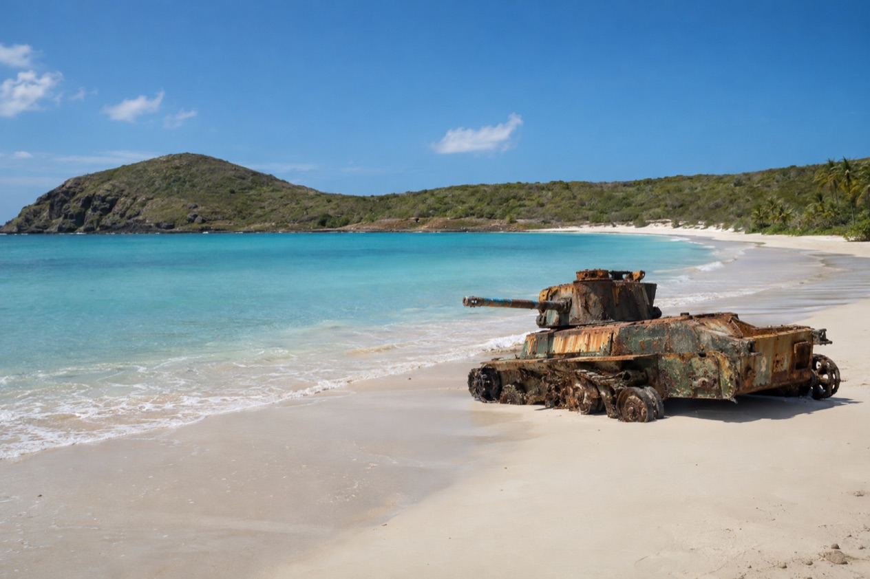
The well-known beach is Flamenco, a broad curve of light sand and transparent shallows, where two rusted Sherman tanks sit abandoned on the shore. On the west side, Tamarindo is a beach for snorkeling, and green sea turtles can often be spotted grazing above the seagrass. Zoni, at the eastern end, is long and quiet and far less visited.
What surprises first-timers is how rural it feels. Feral chickens roam freely across much of the island, there are no rivers or streams, and the landscape is dry and scrubby rather than lush.
The pace is slow, the town is tiny, and the draw is the water and the birds rather than nightlife or shopping. Sea turtles (leatherback, green and hawksbill) use the beaches for nesting, so you may share the shoreline with signs of them, and you give nests and wildlife plenty of room.
Entry, fees and paperwork
Since Puerto Rico belongs to the United States, travelers with U.S. citizenship can arrive without a passport or a visa, and the same holds true for the journey to Culebra. The ferry and the short flight are simply domestic hops from the main island, so what you carry is mostly your beach gear and a sense of patience.
The refuge, which covers much of the island’s best-known coastline and 21 offshore cays, keeps its public areas and hiking trails open every day of the week, from early morning to early evening. Plan your beach and trail time around the refuge’s opening hours.
| Place | Open |
|---|---|
| Culebra National Wildlife Refuge (public areas and hiking trails) | Every day, 6:00 AM to 6:00 PM |
The refuge can answer questions by email at [email protected], which is useful if you are planning around a particular trail or beach. The refuge was established in 1909 by President Theodore Roosevelt, which makes it one of the oldest bird sanctuaries on U.S. territory and the first site in the Caribbean set aside as a federal wildlife reserve for native birds. The Flamenco Peninsula was used for military training until 1975, and that history is still visible on the sand in the form of the tanks.
Money, cards and tipping
The currency is the U.S. dollar, so there is nothing to exchange and no foreign coins to sort through.
On a small island with one town, though, it is a good habit to arrive with some cash in your pocket. Small kiosks, snack stands near the beaches and little local spots are the kind of places where a few bills come in handy, and the town of Dewey is compact enough that you will not find a bank on every corner. Plan your withdrawals on the main island or in town early in your stay rather than waiting until the last evening.
Tipping follows American habits. In restaurants and bars, a tip for the server is the norm, and people tip the person who guides a snorkeling outing or drives them somewhere in about the same spirit as at home.
In casual beach kiosks, rounding up or leaving a little in the jar is common. Nobody expects extravagance, and the mood is relaxed, but a kind gesture goes a long way in a place where much of the work is seasonal and small-scale.
Getting around and staying connected
Getting to Culebra means a public ferry from Ceiba, on the northeast coast of the main island, or a short flight. From San Juan, the drive to Ceiba takes roughly an hour, and that town’s small airport, José Aponte de la Torre, offers commercial service that is largely domestic. The public ferry to Culebra leaves from Ceiba on the northeast coast.
After arriving, travelers rely on golf carts and bikes they rent to move about, which adds to the appeal. The distances are short, the roads are small, and the pace suits an open-air ride with the wind in your face.
Dewey is the island’s one town, and from there you head out to the beaches. Flamenco draws the biggest crowd, while Carlos Rosario Beach sits just a short stroll away and features a reef near the shore that snorkelers love.
For the cays and the farther beaches, boats are part of island life. Tortuga Beach on Culebrita is protected by the refuge. Expect the day to be shaped by the sea and the sun more than by a timetable, and keep a loose plan so you can follow the weather.
Health, water and the sun
The sun is the first thing to plan for. Culebra is hot and open, shade is scarce on the sandier stretches, and a day of snorkeling or beach-hopping will burn you faster than you expect. Wear a hat, bring plenty of sunscreen, and take breaks under the trees at the edge of the beach.
Water is the island’s quiet constraint. Culebra gets every drop of its fresh water through an undersea pipeline that runs from Puerto Rico by way of Vieques, since the archipelago’s islands are dry and lack any rivers or streams. In practice that means being thoughtful with showers and with drinking water, and carrying a refillable bottle on hot days rather than relying on finding a spot to buy one at every beach.
The sea usually looks inviting, but conditions change from day to day and from beach to beach, and exposed shores can have waves or currents even when the next cove looks gentle. Where a flag, a sign or a lifeguard is present, follow it.
Sargassum seaweed can reach some shores in certain springs and summers, so you may find a beach looking different from the photos. Snorkelers should give turtles space and keep their distance from the coral, which is easy to damage.
Local customs and etiquette
A greeting goes a long way. Say buenos días when you walk into a shop or a small restaurant, buenas tardes later on, and expect a friendly answer. You will hear Spanish and English spoken just about everywhere, yet even a small attempt at Spanish earns a warm welcome and makes the conversation friendlier.
Dress is relaxed. Swimsuits belong on the beach, and in town most people pull on a shirt and shorts or a cover-up before heading to a restaurant or the grocery.
If you step into a church in Dewey, dress a little more modestly and keep your voice low.
The community is close-knit, and fishing is a living tradition. In the middle of July each year, a parade honoring Virgen del Carmen, the fishermen’s patron saint, brings boats into Dewey’s harbor, and should your timing work out, that is a wonderful time to visit. Treat the refuge as the shared treasure it is.
Good to know before you go
The Atlantic hurricane season runs from June 1 to November 30, with the peak in September, so travel in those months deserves a look at the forecast. Watch what the National Hurricane Center puts out, along with notices from island authorities, since conditions can change fast. Ensenada Honda is considered the most hurricane-secure harbor in the Caribbean, a sign of how the island’s sailors have long thought about storms.
Keep your ferry or flight confirmation handy, along with any receipts for your rentals, and make one last habit your own: fill your water bottle in the morning, because the best beaches are often a little way from the nearest shop.
Sources
- U.S. Fish and Wildlife Service, Culebra National Wildlife Refuge (https://www.fws.gov/refuge/culebra), checked October 8, 2026
- Wikipedia, Culebra (https://en.wikipedia.org/wiki/Culebra,_Puerto_Rico), checked October 8, 2026
- Wikipedia, Ceiba (https://en.wikipedia.org/wiki/Ceiba,_Puerto_Rico), checked October 8, 2026
- Wikipedia, Cayo Icacos (https://en.wikipedia.org/wiki/Cayo_Icacos), checked October 8, 2026
- NOAA National Hurricane Center, Climatology (https://www.nhc.noaa.gov/climo/), checked October 8, 2026
To plan your stay
- Best Time to Visit Culebra: Weather by Month, Beaches, Crowds and Festivals
- Things to Do in Culebra: Flamenco Beach, Snorkeling with Sea Turtles, Wildlife Refuge and Island Life
- Culebra from San Juan: Road to Ceiba, Ferry or Flight, and a Day on the Island
- Culebra in January: Weather, Flamenco Beach, Snorkeling and a Two-Day Plan