
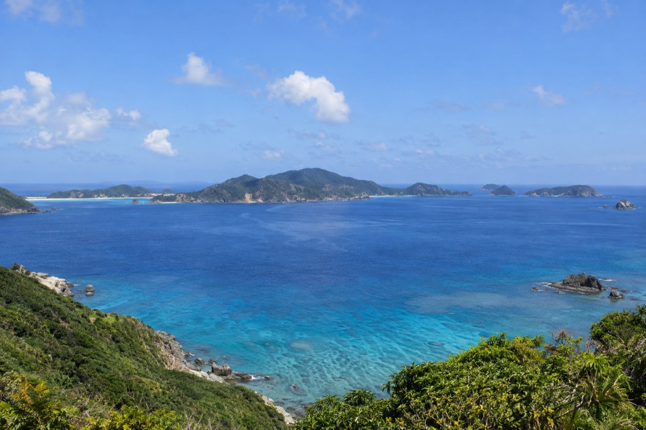
The ferry from Naha slows as it nears the Kerama Islands, and the water below the hull turns from deep navy to a glassy blue that makes people lean over the rail. Small green islands rise out of it, their coves ringed in pale sand and reef.
Is visiting the Kerama Islands worth it?
Yes, if you come to Okinawa for the water more than for the sights on land. The Kerama Islands are a popular beach and diving destination for visitors to Okinawa, and the reefs here are the reason. They hold 248 coral species, most notably of the Acropora genus, and the waters and islands sit inside Kerama Shoto National Park.
What sets the group apart from the beaches of Okinawa’s main island, such as Manza Beach, Emerald Beach or Zanpa Beach, is the scale and the pace. Four islands are inhabited (Tokashiki, Zamami, Aka and Geruma), and you reach them by boat rather than by road. Time is organized around the harbor, the beach and the reef, not around a list of monuments.
It suits less well a traveler who wants temples, castles or museums, since the pleasure here is outdoors. Divers who have seen Okinawa’s other sites, such as the Blue Cave on the main island or the sunken destroyer off Kouri Island, will find a different kind of dive here, centered on coral.
What to see at the Kerama Islands
The coral reefs and the Ramsar sites
The reefs are the heart of the group. Two coral areas were designated Ramsar sites in November 2005: a 120-hectare stretch along the west coast of Tokashiki and around Hanari Island, and a 233-hectare area around Ijakaja, Gahi and Agenashiku Islands, between Aka and Zamami.
Those names matter because the Acropora corals here, with their branching and tabletop shapes, are what boat operators and dive shops build their outings around. Under the surface you may see fish moving between the coral heads, and the color of the water changes with the depth and the sand below.
Zamami, Aka and Tokashiki
The three largest islands are the ones with regular ferries from Naha. Each has its own village harbor and its own beaches, so many visitors choose one island as a base and treat the others as a second day. Boats also run between the islands, which makes it possible to pair two of them.
Aka and Zamami sit on either side of the reef area where the second Ramsar site lies, so the sea between them is where much of the coral interest is concentrated. Tokashiki, on its west coast, faces the first protected area. Geruma is the fourth inhabited island of the group.
Kerama Airport on Fukaji Island
Kerama Airport is on Fukaji Island, one of the smaller islands of the group. It is a reminder that the archipelago is more than the three ferry ports, and that the islands are linked to Okinawa’s wider network, which centers on Naha Airport. Most travelers will not use it, but it explains the map: the islands are a scattered chain of land, with water between each piece, and the sea is the road.
A wartime landing
The islands also carry a chapter of the Battle of Okinawa. Soldiers of the 77th Infantry Division landed here on March 26, 1945, and the group was secured over the next five days, before the fighting moved to the main island.
Knowing this changes the feel of the quiet villages and hillsides. The calm of a harbor today sits beside a history that visitors to Okinawa often meet again in Naha and on the main island.
Hours, tickets and rules
The Kerama Islands are an open stretch of islands and sea rather than a single ticketed site, so there is no one opening time or gate. The one set of hours the sources give for the area is for Okinawa Churaumi Aquarium on the main island, a natural companion for anyone who wants to see Okinawan marine life from dry land the day before or after.
| Site | Open |
|---|---|
| Okinawa Churaumi Aquarium | 08:30 to 18:30, last admission 17:30 |
One caution comes from the aquarium itself: it warns visitors about an increase in bite-wound injuries from white-banded triggerfish during their breeding season. The diving season in Japan is open all year round.
How to get to the Kerama Islands
Everything starts in Naha, the largest city in Okinawa and home to about 21% of the main island’s residents. Naha Airport is the gateway to all of Okinawa’s islands, served by flights from dozens of cities across Japan, including low-cost carriers. Naha also has Okinawa’s only public rail network, the Okinawa Urban Monorail, known as Yui Rail.
From Naha, regular ferries run to the three largest islands: Aka, Zamami and Tokashiki. Ferries between the islands are also available, as are boat tours, so you can link two islands in one trip or join a tour that moves around the group.
There is also an airport on Fukaji Island in the group. For a first visit, the Naha ferry is the link the sources describe in detail, and it ties the islands to the rest of the Okinawa trip. Okinawa Island itself lies far to the south of Kyushu, which is why most visitors arrive by air and then take to the water.
When to visit the Kerama Islands
The diving season is open all year round in Japan, so there is no closed season for the sea itself. What changes is the air, and the figures for Naha give a good guide to the nearby islands without being the islands’ own readings. They are in the table.
| Month | Average high (°F) | Average low (°F) | Precipitation (in) | Rain days | Sunshine (hours) |
|---|---|---|---|---|---|
| January | 67.6 | 58.8 | 4.00 | 10.2 | 93 |
| April | 75.7 | 66.4 | 6.34 | 10.3 | 121 |
| July | 89.4 | 80.6 | 7.41 | 9.4 | 227 |
| October | 82.6 | 74.3 | 7.06 | 8.8 | 163 |
July brings the most sunshine and the hottest air, which suits a day spent in and on the water, though the highs are in the upper 80s. October is still warm, with lows in the mid-70s, and it has the fewest rain days of the four months shown. April sits in the middle, warm but with a lot of rain across the month.
January is the mildest, with highs in the upper 60s and the least sunshine. It is a month for the villages and the views more than for long hours in the sea. Showers can come in any of these months, so a day by the water is best held loosely.
Tips for your visit
Think of the islands as a day or an overnight from Naha. Choosing one of the three ferry islands and staying put gives a fuller day than trying to see all of them. If you have a second day, boats between the islands let you add one more.
Bring what you would for a beach day: swimwear, a towel, and a change of clothes for the ferry home.
Other Okinawan coasts make good companions. The main island has beaches such as Manza, Emerald, Okuma, Zanpa, Moon and Sunset Beach in Chatan, and dive sites like the Blue Cave and the USS Emmons wreck off Kouri Island. Naha itself is easy to fold into the plan, since it is where the ferries and the airport meet.
Good to know before you go
Plan the trip around the sea and the weather: showers are possible in any month, and the sources do not give a ferry schedule, so shape the day around the boats you find rather than a fixed hour. The reefs are protected as part of Kerama Shoto National Park, which was established on March 5, 2014, so treat the coral with care and look rather than touch.
Sources
- Japan National Tourism Organization, diving (https://www.japan.travel/en/guide/diving/), checked October 11, 2026
- Wikipedia, Kerama Islands (https://en.wikipedia.org/wiki/Kerama_Islands), checked October 11, 2026
- Japan National Tourism Organization, Okinawa (https://www.japan.travel/en/destinations/okinawa/okinawa/naha-and-the-main-island/), checked October 11, 2026
- Okinawa Churaumi Aquarium (https://churaumi.okinawa/en/), checked October 11, 2026
- Wikipedia, Okinawa Island (https://en.wikipedia.org/wiki/Okinawa_Island), checked October 11, 2026
- Japan Meteorological Agency (JMA), Normal values 1991-2020, monthly (https://www.data.jma.go.jp/stats/etrn/view/nml_sfc_ym.php?prec_no=91&block_no=47936), station Naha, elevation 28 m, checked October 11, 2026
To plan your stay
- Best Time to Visit Japan: Cherry Blossoms, Autumn Colors, Weather and Festivals
- Where to Stay in Japan: Ryokan, Temple Stays, Capsule Hotels and the Best Cities to Base In
- Sending Luggage from the Airport in Japan: Hands-Free Travel, Hotel Delivery and Coin Lockers
- Know Before You Go to Japan: Entry, Money, Etiquette and Getting Around