
At a highway junction in the Interior, trucks idle outside a roadhouse, the spruce and birch close in on both sides, and the next town is hours down the road. Here the map opens up and the pace follows it. Interior Alaska is a region of long drives, small gold-era towns, one real city and a great deal of wild country, made for travelers who like their trips to unfold along a road.
Where is Interior Alaska and what is it like?
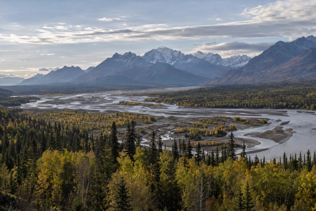
Interior Alaska is the central region of the state, roughly bounded by the Alaska Range on the south and the Brooks Range on the north. It has no ocean shoreline to define it. What defines it instead are river valleys, forests and a handful of highways that tie its towns together, and the region is home to more than a hundred thousand people.
Fairbanks is the anchor. It is the largest city in the Interior and the second-largest in Alaska, with a 2020 census count of 32,515 in the city proper. It sits on the Chena River, where E. T.
Barnette set up a trading post in August 1901, and it is also the home of the University of Alaska. The Arctic Circle lies 196 miles away by road, so Fairbanks feels like the last big town before the true far north.
Beyond Fairbanks the region becomes a string of small places on the Richardson, Alaska, Taylor and Parks highways. Delta Junction calls itself the Crossroads of Alaska. Tok is a junction town between the Tanana River and the Alaska Range. Chicken is a popular rest stop on the Taylor Highway, and Eagle keeps Gold Rush-era buildings in a National Historic Landmark district. Nenana is a river town on the Parks Highway.
The Interior suits people who enjoy the journey itself: road trippers, history lovers, travelers who want a real Alaska town with a university and a main street, and anyone curious about the country that sits between the mountain ranges. It is less suited to travelers who want a dramatic coastline or a single postcard viewpoint.
Tok, for instance, is mostly flat, with young forests recovering from wildfires, and its appeal is as a place to rest and refuel, not as a showpiece. The reward comes in the whole sweep of it, and in the roadhouses, rivers and quiet that fill the miles in between.
What is there to do in Interior Alaska?
The big reasons to come are the city of Fairbanks, the road to Denali, the historic highway towns and the roadless river country in the east. Each is a different kind of trip, and together they show what sets the Interior apart from the coastal parts of the state: the days are spent among rivers, forests and mountain ranges rather than on the water.
Fairbanks and the Chena River
Fairbanks is the natural base for a visit. The town began as a trading post on the south bank of the Chena River and was incorporated as a city in November 1903, so its story is bound up with gold, river traffic and the road network that grew around it. It is also a college town, which gives it the cafés, lectures and a livelier feel than you would expect so deep in the Interior.
Use Fairbanks as the place to stock up, sleep in a proper bed and orient yourself before heading out on the highways. Both the Richardson Highway and the Parks Highway end here, so almost every road trip in the region either begins or finishes in town.
Denali and the Park Road
Denali National Park and Preserve was established in February 1917 and is named for the highest peak in North America, which rises to 20,310 feet. The George Parks Highway is the principal access to the park, and it also serves Denali State Park. For visitors the park means the Denali Park Road, which starts at the Parks Highway and ends at Kantishna.
Private vehicles can drive only the first 15 miles of the road, up to the Savage River Bridge. Beyond that, the park interior is reached only by shuttle or tour bus. The road itself runs for 92 miles, so the trip into the park is something to plan around rather than an add-on to a day in town.
Highway towns and Gold Rush history
The towns along the roads are a destination of their own. Delta Junction has the oldest roadhouse in the Interior and sits where the Alaska Highway ends and meets the Richardson Highway. Chicken, on the Taylor Highway, is a popular rest stop, and farther along that road Eagle preserves many of its Gold Rush-era buildings in the Eagle Historic District.
Nenana, on the Parks Highway, adds another river-town stop, and Tok offers a bike trail system where you can pedal or walk to stretch your legs after hours behind the wheel. A scenic drive through the backcountry near Tok might show migrating caribou, though that is a chance, not a promise.
Yukon-Charley Rivers and the roadless east
Yukon-Charley Rivers National Preserve covers more than two and a half million acres along the Canadian border in east central Alaska, and no roads reach it. In summer, access is by water or air, usually by air taxi or boat from Eagle or Circle. Visitors find that driving or flying into Eagle and floating the Yukon River is the most reasonable option, and air carriers can return visitors to the put-in point.
The Charley River can be floated from June through August. Most of it is rated Class II, with some Class III and even Class IV in high water. In winter, access is by air or by more adventurous means such as snowmachines. A flightseeing tour from Tok can also take you over this preserve or over Wrangell-St. Elias National Park.
How many days do you need in Interior Alaska?
A long weekend gives you Fairbanks and a taste of the highways, while a week lets the Interior unfold the way it is meant to, one junction town at a time. The region is large and the distances are real, so the right length depends on how much of the road you want to cover.
Walk the town along the Chena River, learn the Gold Rush story, and make one outing along a highway. A night in a roadhouse town gives you a feel for the region that a day in the city cannot.
With a week, add Denali. The park deserves its own time, because getting into the interior of the park means taking a bus down the Park Road rather than driving your own vehicle. Pair it with the Parks Highway towns, including Nenana, on your way between the park and Fairbanks, and you have a loop that mixes mountains, rivers and small-town stops.
With more time, head east. Tok makes a natural first night for anyone coming into Alaska on the Alaska Highway, and from there the road continues to Delta Junction. The Taylor Highway leads to Chicken and Eagle, a trip that rewards a slower schedule.
Anyone who wants the wilderness side can add a float on the Yukon River from Eagle or a flightseeing tour out of Tok. Those are the days that turn a road trip into an expedition.
Where to stay in Interior Alaska
Fairbanks suits travelers who want the most choice and the most services in one place. It is the largest city in the region and a natural base for day outings, and it works for anyone who prefers to return to the same bed each night. It also suits those who want restaurants, a university town atmosphere and easy access to both the Richardson and Parks highways.
Delta Junction suits road-trippers. It sits where the Alaska Highway ends, and it has the oldest roadhouse in the Interior. The Lodge at Black Rapids is a lodging option there, and a single night is the advised stay. It is a good pause for travelers heading between Fairbanks and the rest of the highway system.
Tok has numerous campgrounds, inns and B&Bs, which makes it a great first night in Alaska for anyone arriving from Canada on the Alaska Highway. Its setting is flat and not especially scenic, so think of it as a comfortable stop on a longer route and not as a place to linger. Campers and RV travelers will find it especially practical.
For a more historic setting, Eagle keeps its Gold Rush-era buildings in a National Historic Landmark district and is the usual starting point for Yukon-Charley river trips. Chicken, as a rest stop on the Taylor Highway, works as a break on the way there. Near Denali, the Parks Highway is the principal access to the park, so lodging along that road is the natural choice for a Denali visit.
How do you get to Interior Alaska and get around?
Visitors arrive by road, and the highways are the backbone of the region. The George Parks Highway runs 323 miles from the Glenn Highway to Fairbanks and is the principal access to Denali. The Richardson Highway, 368 miles long, connects Valdez to Fairbanks and was the first major road built in Alaska. Its southern end is at the Alaska Marine Highway terminal in Valdez.
The Alaska Highway, 1488 miles from Dawson Creek, British Columbia, through Whitehorse, Yukon, ends at Delta Junction. From Anchorage, the most direct route to Delta Junction is the Glenn Highway to the Richardson Highway and then north. An alternate route follows the Parks Highway and then the largely unmaintained Denali Highway, meeting the Richardson at Paxson.
| Route | Time |
|---|---|
| Anchorage to Delta Junction (drive) | 6 hours |
| Fairbanks to Delta Junction (drive) | 1.5 hours |
| Tok to Anchorage (Interior Alaska Bus Line) | 7.25 hours |
| Tok to Fairbanks (Interior Alaska Bus Line) | 4 hours |
| Tok to Delta Junction (Interior Alaska Bus Line) | 1.75 hours |
Without a car, the Interior Alaska Bus Line runs year-round on Mondays, Wednesdays and Fridays between Tok and Anchorage, and between Tok and Fairbanks. Reservations should be made in advance, and travelers should allow flexibility because buses may be rescheduled based on demand.
Air service is limited in the smaller towns. Delta Junction has a small public-use airport, with one small operator offering scheduled flights from Fairbanks three times a week, and other flights there require chartering.
Yukon-Charley Rivers National Preserve has no road access at all, so air taxis and boats take over. In Denali, private vehicles stop at the Savage River Bridge and a shuttle or tour bus carries you the rest of the way. In Tok, the bike trail system lets you get around on two wheels or on foot.
When is the best time to visit Interior Alaska?
June through August is the clear choice for most trips. Summer temperatures in Fairbanks average 62°F, and in Delta Junction the average high runs from the mid-60s in August to just under 70 in July. The Charley River can be floated in those same months, so summer is also when the river country opens up for visitors.
Winter is another world. Fairbanks averages a winter temperature of −12°F, and in Delta Junction the average daily low stays below zero from December through February. The record low there is −63°F.
Tok has a dry-winter continental subarctic climate with warm summers and severely cold winters. A winter trip is for travelers who are comfortable with real cold and who plan around it, and the Yukon-Charley preserve can then be reached by air or by adventurous options such as snowmachines.
The seasons between are shorter and less predictable, and the best months for a given plan depend on what you want to do. Road trips along the Alaska, Richardson and Parks highways suit the summer months. Wildlife is always a matter of chance, and migrating caribou may be seen on a drive through the backcountry near Tok.
Good to know before you go
Distances in the Interior are long, and some stretches of the road system are lightly served, so plan each leg of a drive with the next town in mind. In Delta Junction, a visitor information center run by the local chamber of commerce stands at the intersection of the Alaska Highway and the Richardson Highway.
The Denali Highway is largely unmaintained, and the Yukon-Charley preserve has no roads at all. Take cold seriously in the long winter, when temperatures fall well below zero, and for the Interior Alaska Bus Line, reserve in advance and allow flexibility in your schedule.
Sources
- Wikivoyage, Interior Alaska (https://en.wikivoyage.org/wiki/Interior_Alaska), checked October 11, 2026
- Wikipedia, Interior Alaska (https://en.wikipedia.org/wiki/Interior_Alaska), checked October 11, 2026
- Wikipedia, Fairbanks, Alaska (https://en.wikipedia.org/wiki/Fairbanks,_Alaska), checked October 11, 2026
- Wikipedia, Denali National Park and Preserve (https://en.wikipedia.org/wiki/Denali_National_Park_and_Preserve), checked October 11, 2026
- Wikipedia, George Parks Highway (https://en.wikipedia.org/wiki/George_Parks_Highway), checked October 11, 2026
- Wikipedia, Richardson Highway (https://en.wikipedia.org/wiki/Richardson_Highway), checked October 11, 2026
- Wikipedia, Delta Junction, Alaska (https://en.wikipedia.org/wiki/Delta_Junction,_Alaska), checked October 11, 2026
- Wikivoyage, Delta Junction (https://en.wikivoyage.org/wiki/Delta_Junction), checked October 11, 2026
- Alaska.org, dest delta junction (https://www.alaska.org/destination/delta-junction), checked October 11, 2026
- Wikipedia, Tok, Alaska (https://en.wikipedia.org/wiki/Tok,_Alaska), checked October 11, 2026
- Wikivoyage, Tok (https://en.wikivoyage.org/wiki/Tok), checked October 11, 2026
- Alaska.org, dest tok (https://www.alaska.org/destination/tok), checked October 11, 2026
- Wikipedia, Nenana, Alaska (https://en.wikipedia.org/wiki/Nenana,_Alaska), checked October 11, 2026
- Wikipedia, Yukon–Charley Rivers National Preserve (https://en.wikipedia.org/wiki/Yukon–Charley_Rivers_National_Preserve), checked October 11, 2026
- National Park Service, Yukon-Charley Rivers National Preserve, plan your visit (https://www.nps.gov/yuch/planyourvisit/index.htm), checked October 11, 2026
- Wikipedia, Climate of Alaska (https://en.wikipedia.org/wiki/Climate_of_Alaska), checked October 11, 2026