
In Fairbanks, a baseball game starts late at night under a sky that never quite goes dark, and the crowd treats it as the most natural thing in the world. Across the border in the Yukon, the evening light lingers over the Alaska Highway while a canoe slides down a quiet river and the first campfires are lit. Alaska and Canada’s northwest share mountains, glaciers and a taste for big empty country, but they feel different once you are there, and the choice comes down to what kind of trip you want.
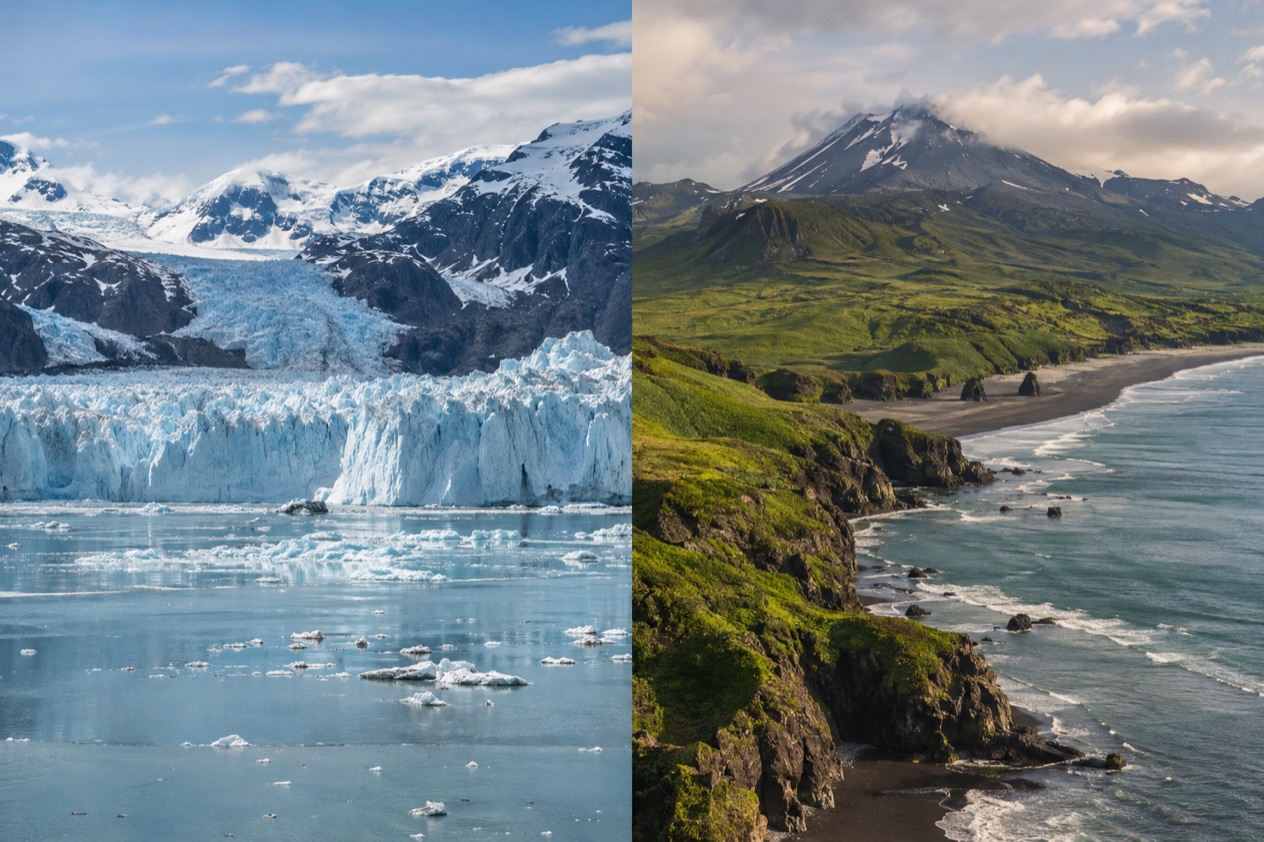
Which is better, Alaska or Canada?
Alaska suits travelers who want glaciers, national parks and wild country on a grand scale, while Canada, here meaning the Yukon and the Canadian Rockies, suits those who want mountain towns, a road-trip rhythm and a quieter northern frontier. Neither wins outright.
The Alaska side offers the tallest peak on the continent and a coastline of fjords and forest. The Canadian side offers the Rockies parks, a gold rush past and a capital city that sits right on the Alaska Highway.
The table sets the two side by side in plain terms. The sections after it go into each row with the details that matter for planning.
| Category | Alaska | Canada (Yukon and the Canadian Rockies) |
|---|---|---|
| Scenery | Glaciers, fjords, rainforest and the highest mountain in North America | Rocky Mountain peaks, glacier-fed lakes and the highest mountain in Canada |
| Vibe | Vast, sparsely settled, with many towns off the road system | Mountain-park towns in the Rockies, small frontier towns in the Yukon |
| Things to do | National parks, glacier cruises, bus rides into Denali, small-town festivals | Hiking, canoeing, dog sledding, museums, gold rush history, Rockies national parks |
| Wildlife | Chances at bears, moose, whales and eagles in parks and along the coast | Chances at wildlife in the Rockies parks and the Yukon backcountry |
| Weather | Wet along the southeast coast, very snowy in places, long polar days far north | Dry in Whitehorse, cold winters in the Yukon, long summer light |
| Getting there | Flights to Alaska cities, ferries and planes to roadless towns, or the Alaska Highway through Canada | Whitehorse airport, the Alaska Highway, the Yellowhead Highway near Mount Robson |
| Best for | Glacier and national park trips | Road trips, mountain towns and northern history |
Scenery and wildlife
Alaska’s scenery starts with Denali, which rises to 20,310 feet and is the highest mountain in North America. On the coast, Southeast Alaska is wrapped in the Tongass National Forest, the largest national forest in the country.
Glacier Bay National Park and Preserve covers more than three million acres of ice, water and mountains, and no roads lead to it. The park is part of a UNESCO World Heritage Site that Alaska shares with parts of Canada.
Canada’s counterpart begins in the Yukon, where Kluane National Park and Reserve holds Mount Logan, the highest mountain in Canada at 19,551 feet. Farther south, the Canadian Rockies stretch through five national parks: Banff, Jasper, Kootenay, Yoho and Waterton Lakes. Mount Robson, the highest peak in the range at 12,972 feet, stands in British Columbia near Yellowhead Pass. Rivers such as the Bow, the Athabasca and the Columbia begin in these mountains.
Wildlife on both sides is a matter of chance. In Alaska’s parks and along its coast you may see bears, moose and whales, and in the Yukon and the Rockies you may come across large animals from a roadside or a trail.
The aurora borealis can be seen in the Yukon because of its latitude, and the same is true of much of Alaska. Light shapes the experience too. Fairbanks sees its sun set at 12:47 a.m. around the summer solstice, and Whitehorse has up to about 19 hours of daylight in summer.
For sheer scale, with glaciers meeting water and mountains rising straight from wilderness, Alaska takes the prize. For a mountain landscape of lakes and peaks that you can pair with towns, the Canadian Rockies hold their own, and the Yukon adds a quieter, wilder north. Pick Alaska for ice and fjords, and Canada for ranges and lakes.
Things to do
In Alaska the national parks lead the list. Denali National Park and Preserve was established in 1917, and Denali Park Road runs 92 miles from the George Parks Highway to Kantishna.
Private vehicles can drive only the first 15 miles, up to Savage River Bridge, so most of the road is seen from beyond that point by other means. Glacier Bay, reached by air or sea, is a place for looking at ice and water from the deck of a boat or from the shore.
Beyond the parks, Alaska’s towns have their own character. Juneau, the capital, cannot be reached by road, and Southeast communities rely on the Alaska Marine Highway, so the water itself becomes part of the trip.
In Fairbanks the Midnight Sun Game, a baseball contest played in the twilight around midnight on June 21, has been held since 1906. Utqiaġvik, the northernmost city in the country, offers a very different Alaska, one shaped by the polar day and the polar night.
Canada’s side is built around trails, water and history. Yukon outfitters and guides offer angling, canoeing and kayaking, hiking, skiing, snowboarding, ice climbing and dog sledding. Whitehorse has four museums, including the MacBride Museum of Yukon History, the Yukon Beringia Interpretive Centre and the Yukon Transportation Museum, plus the MacBride Copperbelt Mining Museum. Mount Sima, a ski hill, turns to mountain biking in summer.
The Klondike story is part of the Yukon’s draw. The Tr’ondëk-Klondike World Heritage Site was designated in 2023, giving the gold rush country a place on the same kind of list as Kluane.
The White Horse Rapids that gave Whitehorse its name now lie under Miles Canyon and Schwatka Lake because of a dam. In the Rockies, the Alpine Club of Canada maintains a series of alpine huts for mountaineers and adventurers, a different side of the range from the parks’ main routes.
Weather and the best time to go
Alaska’s weather depends on where you stand. Juneau averages over 50 inches of precipitation a year, and some parts of Southeast Alaska receive as much as 275 inches, which explains the rainforest. Valdez gets up to 300 inches of snow annually. Far to the north, Utqiaġvik has a polar day of 84 days and a polar night of 68 days, so light and dark there come in long blocks rather than daily rhythms.
Canada’s northwest is drier. Whitehorse is Canada’s driest city, with about 55.8 inches of snow and 6.33 inches of rain in an average year. It has a subarctic climate that is milder than other comparable northern places because of its valley setting. Winter can still be fierce in the Yukon, and the town of Snag once recorded a temperature of minus 81.4 degrees Fahrenheit.
What this means for timing is simple. If you want to be outdoors in long daylight, the northern summer gives Whitehorse up to about 19 hours of light, and Fairbanks has twilight well past midnight around the solstice.
If you want snow, dog sledding or a chance at the aurora, the Yukon and interior Alaska both have the cold and the dark in winter. Southeast Alaska, by contrast, asks you to bring rain gear whenever you come.
The Rockies add another pattern. Skiing and ice climbing belong to the cold months, and hiking and canoeing belong to the warm ones, in the same way the Yukon outfitters organize their seasons. Services in Alaska, from boat trips to park buses, follow their own calendars, so the month of your trip decides what is open on either side of the border.
Getting there and getting around
Getting around Alaska means accepting that much of it is off the road system. Juneau is not connected by road to the rest of the North American highway system.
Of the Southeast communities, only Haines, Hyder and Skagway have direct road connections, and the others rely on the Alaska Marine Highway. Glacier Bay is reached by air or sea. The state covers 586,000 square miles and has few people for its size, so distances shape every plan.
On the Canadian side, Whitehorse is the gateway to the Yukon. It is the capital and the largest city in Northern Canada, served by Erik Nielsen Whitehorse International Airport, and it sits at Historic Mile 918 on the Alaska Highway. In the Rockies, the Yellowhead Highway passes near Mount Robson, a different corridor in a different range.
The two sides connect by road. Travelers from the contiguous U.S. can drive to Alaska on the Alaska Highway through Canada, which is paved and maintained year-round. Yukon and Alaska share a border of 750 miles, mostly along the 141st meridian west. Driving north therefore means passing through Canada first, and the Yukon becomes part of the route.
A rental car has limits in Alaska. Many rental companies prohibit their vehicles on the Dalton, Denali, Steese and Cassiar Highways and on the Nabesna and McCarthy Roads, and insurance may not cover damage there. In Denali, private vehicles stop at Savage River Bridge. Plan around those boundaries rather than against them.
Who should choose which
Choose Alaska if the pictures in your head are of glaciers, enormous mountains and national parks with few roads. It is the better choice for a trip built around Denali, Glacier Bay or the Southeast coast, and for travelers who like the idea that a capital city can only be reached by air or water. It also suits anyone drawn to the extremes of light, from the Fairbanks midnight ballgame to the polar day in Utqiaġvik.
Choose Canada if you want mountain scenery paired with towns, museums and a road-trip feel. The Rockies give you five national parks and a UNESCO-listed block of mountain country, and the Yukon gives you Kluane, the Klondike story and guided adventures from canoeing to dog sledding. Whitehorse, the driest city in Canada, is a practical base for exploring the north.
The two combine well, and the geography nearly insists on it. Driving to Alaska means crossing the Yukon on the Alaska Highway, so a northern road trip can include Whitehorse, Kluane and then the Alaska side.
Kluane and Glacier Bay belong to the same World Heritage Site, which makes pairing them a natural theme. A trip that stays on one side will feel complete, but one that crosses the border shows how much the two places share.
Good to know before you go
Alaska observes all federal holidays except Columbus Day, and adds Seward’s Day on the last Monday in March and Alaska Day on October 18. Daylight changes the feel of a trip on both sides of the border, with long evenings in the Yukon and Fairbanks in summer and short days in winter. Because rental car rules, park roads and seasonal services differ from place to place, the details of each stop deserve a look before you set out.
Sources
- Wikipedia, Alaska (https://en.wikipedia.org/wiki/Alaska), checked October 11, 2026
- Wikivoyage, Alaska (https://en.wikivoyage.org/wiki/Alaska), checked October 11, 2026
- Wikipedia, Climate of Alaska (https://en.wikipedia.org/wiki/Climate_of_Alaska), checked October 11, 2026
- Wikipedia, Midnight sun (https://en.wikipedia.org/wiki/Midnight_sun), checked October 11, 2026
- Wikipedia, Denali National Park and Preserve (https://en.wikipedia.org/wiki/Denali_National_Park_and_Preserve), checked October 11, 2026
- Wikipedia, Glacier Bay National Park and Preserve (https://en.wikipedia.org/wiki/Glacier_Bay_National_Park_and_Preserve), checked October 11, 2026
- Wikipedia, Yukon (https://en.wikipedia.org/wiki/Yukon), checked October 11, 2026
- Wikipedia, Canadian Rockies (https://en.wikipedia.org/wiki/Canadian_Rockies), checked October 11, 2026
- Wikipedia, Whitehorse (https://en.wikipedia.org/wiki/Whitehorse), checked October 11, 2026