
A small plane drops toward the Kobuk River, and below the wing a pale patch of sand appears in the middle of the Arctic tundra, as if a piece of desert had been set down by mistake. Beyond it, the river winds through spruce and willow, and the ground is crossed by thousands of caribou trails. Kobuk Valley National Park has no road, no trail and no campground, so a visit here means arriving by air and then traveling entirely on your own terms.
Is visiting Kobuk Valley National Park worth it?
It is worth it for travelers who want true wilderness and are ready to organize a self-sufficient trip, and it is not the park for anyone who wants a lodge, a paved overlook or a visitor center at the trailhead. The park sits in the Arctic region of northwestern Alaska, about 25 miles north of the Arctic Circle, and it asks for planning, flexibility and gear before it gives anything back.
What sets it apart from the other big parks of the region is the mix of things packed into one river valley. The Great Kobuk Sand Dunes form the largest active Arctic dune field in North America, and the valley also lies along the route of the Western Arctic caribou herd, which crosses the Kobuk River on its yearly migration. Add a river that people travel by boat, a wilderness area south of that river, and the long Arctic light, and you have a place that feels unlike anywhere else in Alaska.
It is also a quiet park in the plain sense of the word. Nothing is built for visitors inside its boundaries, so the days are shaped by weather, by the pilot you fly with and by what you carried in.
Travelers who enjoy that kind of open-ended trip, with backpacking, boating or flightseeing as the main activities, tend to find the effort part of the appeal. Those who need fixed schedules will be more comfortable elsewhere in Alaska.
What to see at Kobuk Valley National Park
The park is the valley of the Kobuk River, and nearly everything worth seeing is tied to the river, the sand or the animals that cross both. Because there are no roads or trails, each sight below is reached by air first and then on foot or by boat.
The Great Kobuk Sand Dunes
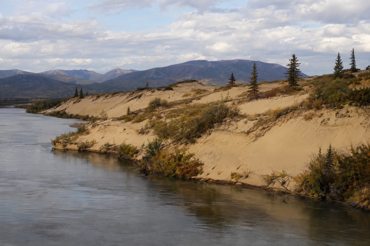
The dunes are the image most people carry away from Kobuk Valley, and they are the reason many travelers come at all. The park includes three sets of dune fields, and the Great Kobuk Sand Dunes are the biggest, a rolling expanse of sand set against dark spruce and Arctic sky. The sand is moved by wind, which is why the field counts as active, with ridges that shift in shape over time.
There is no road or trail to them, so visitors must hire a pilot to get there. Once on the ground, you see ripples and slopes of sand, animal tracks pressed into it, and a horizon with no building in sight. Caribou tracks are among the things you may find in the sand.
The Kobuk River and the caribou crossings
The river is the spine of the park and its main highway for anyone with a boat or a raft. It is also the line that the Western Arctic herd crosses on its migration, between winter breeding grounds south of the Waring Mountains and summer calving grounds north of the Baird Mountains. The animals are the most visible wildlife in the park, and you may see groups moving across the valley or entering the water.
Seeing caribou is a chance, not a promise, since the herd follows its own calendar and the weather. Boating and guided rafting trips on the river give the best sense of the valley’s scale, with the banks sliding past at the speed of the current. Commercial businesses offer guided rafting for visitors who prefer not to organize it alone.
Onion Portage and Kallarichuk
Two seasonal ranger stations stand along the Kobuk River, one at Kallarichuk at the west end of the park and one at Onion Portage at the east end. They mark the two ends of the park for anyone planning a river trip, and they are the places where the National Park Service has a presence on the ground.
Onion Portage is a name that carries weight among archaeologists and in the story of caribou hunting along the river, which makes it an interesting place to understand how long people have lived with this migration. Rangers are stationed at these two points only seasonally, so they are a feature of the map more than a fixed service to count on.
The Northwest Arctic Heritage Center in Kotzebue
The park’s visitor center is not in the park at all but in Kotzebue, on the Bering Sea coast, about 100 miles west of the valley. The Northwest Arctic Heritage Center offers park information, free film viewings and a museum about the Arctic ecosystem and Inupiaq culture. Most trips pass through Kotzebue anyway, so the center is a natural first stop.
Inside, the museum gives context for what you will see from the air: how the tundra works, how animals and people share the land, and how Inupiaq families have lived in this region. The center is handicap accessible and offers a wheelchair on request, which makes it the one part of a Kobuk Valley trip that is open to every kind of visitor.
Hours, tickets and rules
The park never closes, since there are no gates, no entrance station and no road to block. It is open year-round, but reaching it depends on flights that run all year and are always at the mercy of the weather. The only admission amount the park gives is none at all, and there is no ticket window to stand in front of.
| Site | Open | How you reach it |
|---|---|---|
| Kobuk Valley National Park | Year-round | Chartered air taxi, weather-dependent |
| Great Kobuk Sand Dunes | Year-round | Hire a pilot, no road or trail |
Permits are not required for independent travelers but are required for organized groups. Photography and special use permits are needed for certain activities, and the National Park Service explains how to get them on its Permits & Reservations page.
Only subsistence hunting by local residents is allowed, and no part of the park is a national preserve, so sport hunting is not permitted here. The park has no roads, no trails and no campgrounds, which means every camp is a backcountry camp. Bear encounters can be reported by phone to the Northwest Arctic Heritage Center front desk.
How to get to Kobuk Valley National Park
You get there by air, and only by air. No road leads into the park, so visitors arrive on a chartered air taxi from Nome, Bettles or Kotzebue, and those flights are available year-round but depend on the weather. Air taxi offices are located in Kotzebue and Bettles, which are the two practical bases for planning.
From Anchorage or Fairbanks, the way in is a flight to Kotzebue or Bettles, followed by coordinating with a local air taxi to take you into the park. That second step is the one that shapes a trip.
You choose your pilot, your landing spot and your plan, and the pilot decides on the day whether the sky allows it. Visitors who want to see the Great Kobuk Sand Dunes must hire a pilot, because there is no other way to reach them.
Kotzebue is also the practical place to prepare. The park headquarters are at the Northwest Arctic Heritage Center there, and visitors must be self-sufficient, stocking up on essentials in Kotzebue before they leave town. Once you fly out, there is nowhere inside the park to buy anything.
Commercial businesses offer air taxis, guided rafting and hunting services for park visitors. Which option fits depends on what you want to do once you arrive, whether that is flightseeing over the dunes, floating the river or backpacking across open country. The park phone number is 907 318-2230, and it rings at the Northwest Arctic Heritage Center.
When to visit Kobuk Valley National Park
The park is open year-round, but the seasons give it very different faces, and winter is a serious undertaking. Visitors must be seasoned in wilderness survival, especially during winter, so a first trip is more realistically a trip in the months of long light.
The park lies above the Arctic Circle, and the sun does not set from June 3 to July 9. In those weeks the day has no real end, which gives you freedom to fly, paddle or walk at any hour, and it also means you will want something to cover the tent windows at night. The long light stretches the day for photography and for watching the river and the tundra change color slowly.
At the other end of the year, the winter solstice brings the sun above the horizon for only about an hour and a half, with long stretches of twilight on either side. Winter travel here, including dog sledding, belongs to people with real cold-weather experience and their own equipment.
For caribou, the herd moves between winter grounds south of the Waring Mountains and summer calving grounds north of the Baird Mountains, crossing the Kobuk River on the way, so the animals may be in the valley at several points in the year. Their timing varies, and a sighting is never certain.
Weather is unpredictable in every season, and flights can be delayed by it, so leave room in your schedule at both ends of the trip. Nothing in the valley follows a visitor’s calendar, which is part of what makes it feel so far from the road system.
Tips for your visit
Bring everything. Because there are no designated trails or roads, park visitors must carry all their own gear for backcountry camping, hiking, backpacking, boating and dog sledding. Stock up on essentials in Kotzebue before the flight, and prepare for unpredictable weather. Internet and cellular access in the park are limited, so plan as if you will be out of contact.
Start your trip at the Northwest Arctic Heritage Center in Kotzebue, where you can pick up park information, watch the free films and walk through the museum about the Arctic ecosystem and Inupiaq culture. The center is the natural way to understand the place before you fly in, and it is accessible to wheelchair users, with a wheelchair available on request.
The park is part of the Western Arctic National Parklands, so a longer Arctic trip can pair Kobuk Valley with time in Kotzebue or Bettles, where the air taxi offices are. Flightseeing is one of the ways to see the park, and it suits travelers who want the dunes and the river without a multi-day expedition.
The valley is bear country. The park has a Bear Safety web page with information on staying safe, and encounters can be reported to the Heritage Center front desk by phone. Much of the land south of the Kobuk River is managed as the Kobuk Valley Wilderness, covering 174,545 acres, so expect country that is left deliberately undeveloped.
For families or travelers with limited mobility, the park itself has no roads, trails or facilities, so the most accessible part of the experience is the Heritage Center in Kotzebue. Anyone planning a trip into the valley should talk with an air taxi operator about what the flights and landings involve.
Good to know before you go
The park was declared a national monument by President Jimmy Carter on December 1, 1978, and became a National Park in 1980. Its sole amphibian is the wood frog, which survives icy winters by freezing solid and waking up again in spring.
Internet and cell service are limited, so settle your plans in Kotzebue or Bettles before you fly. Weather can change quickly and can delay flights, and the park mailing address is PO Box 1029, Kotzebue, AK 99752.
Sources
- National Park Service, Kobuk Valley National Park, plan your visit: basicinfo (https://www.nps.gov/kova/planyourvisit/basicinfo.htm), checked October 11, 2026
- National Park Service, Kobuk Valley National Park, plan your visit: conditions (https://www.nps.gov/kova/planyourvisit/conditions.htm), checked October 11, 2026
- Wikipedia, Kobuk Valley National Park (https://en.wikipedia.org/wiki/Kobuk_Valley_National_Park), checked October 11, 2026
- Wikivoyage, Kobuk Valley National Park (https://en.wikivoyage.org/wiki/Kobuk_Valley_National_Park), checked October 11, 2026