
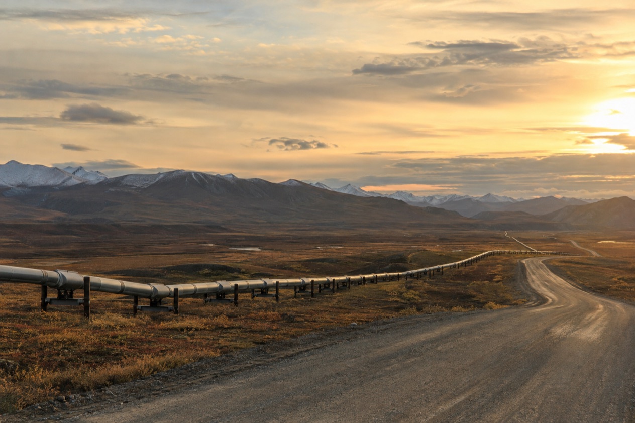
On the Dalton Highway the trucks keep coming, headlights burning in daylight, and past the Brooks Range the trees give out and the tundra opens flat to the horizon. Farther on, in Utqiagvik, a town of mostly Iñupiat families, the land simply ends at the Arctic Ocean. Arctic Alaska is a place of long roads, small planes and big wilderness, for travelers who want to stand at the top of the continent.
Where is Arctic Alaska and what is it like?
It is a region of tundra, wide rivers, big skies and very few people, cut off from the rest of Alaska by the mountains.
Utqiagvik, formerly Barrow, is the northernmost city in the United States and the largest U.S. settlement north of the Arctic Circle. Its residents are primarily Iñupiat, and the community still relies heavily on subsistence hunting and fishing.
When a whale is taken, the meat and blubber are shared across the community by a traditional formula, which says a lot about how the town works. There are no roads or rails into Utqiagvik, so the only way in is by plane.
Inland, the Dalton Highway is the only road that connects the North Slope to the rest of the Alaska road system. It runs from the Elliott Highway north of Fairbanks to Deadhorse, beside the Prudhoe Bay oil fields. Deadhorse is an industrial outpost, and visitors stay in lodgings put together from modular buildings. The setting is unpolished and working, closer to a frontier camp than to a resort.
The wildlife is a large part of the draw. The Arctic coastal plain has the densest concentration of birds in the Arctic, and it is home to whales, walrus, seals, caribou and moose. Protected land covers much of the region, including the Arctic National Wildlife Refuge and the National Petroleum Reserve–Alaska.
The pace here is set by distance, weather and light. This is a region for people who like empty horizons, who are happy to let a plan bend around a flight, and who are curious about Iñupiat life.
It suits travelers less well if they want a lot of restaurants, nightlife or a packed list of attractions. Utqiagvik also has a damp law: alcohol cannot be sold there, though it can be brought in and consumed.
What is there to do in Arctic Alaska?
The big reasons to come are the Arctic Circle itself, the Dalton Highway, the northern edge of the continent at Utqiagvik and Deadhorse, and the wilderness parks of the Brooks Range and beyond. What sets this region apart from the rest of Alaska is the sense of having left the road system, and the light, which shapes every day of a visit.
The Dalton Highway and the Arctic Circle
The Dalton Highway is a road of 414 miles that crosses central and northern Alaska, and driving or riding it is an adventure in its own right. The Arctic Circle is at Mile 115, marked by a pullout with a picnic area and information boards. A short side road at the wayside rest area leads to a viewing deck with interpretive displays, a natural place to stop and take the photo of the sign.
Farther north the road climbs across the Brooks Range at Atigun Pass, which at 4,739 feet is the highest point on the highway. Coldfoot is the main stop in the middle, with a small visitor center staffed jointly by the BLM, USFWS and NPS during the summer.
The speed limit is 50 mph along the entire length, and headlights must stay on at all times. Gas stations are at the Yukon River crossing (closed in winter), Coldfoot and Deadhorse, and north of Coldfoot there are no services for 240 miles.
Tourists typically travel from Fairbanks by tour bus, a two-day journey with an overnight stop in Coldfoot. It suits anyone who wants the scenery without managing the road themselves.
Utqiagvik and Deadhorse at the top of the continent
In Utqiagvik you are on the Arctic Ocean, in a place that is Iñupiat first and a travel stop second. Tundra Tours Inc. offers one tour per day in the summer season, starting at 10:00 AM and ending around 2:30 PM, a way to see the town and the tundra with a local guide. The town’s culture of hunting, sharing and language revival is part of what you take away from a visit.
Deadhorse draws travelers for the tundra, the Arctic Ocean and the midnight sun. One detail surprises people: the bay itself is 10 miles farther north through a security checkpoint, so open water is not visible from the highway. Summer visitors can experience the midnight sun in Deadhorse, while in winter the polar night takes over.
Wilderness parks: Gates of the Arctic, Kobuk Valley and the Arctic Refuge
Gates of the Arctic National Park and Preserve protects 8.4 million acres in the central Brooks Range, with towering mountains, tundra, boreal forest, icy rivers and lakes. It has no roads, no trails and no established campsites, so visitors experience solitude and nature on its own terms.
Entry has no fee and needs no registration, though visitors are asked to stop at a visitor center for a backcountry orientation. People arrive by air taxi in small aircraft with floats or tundra tires, and the park is for people proficient in outdoor survival skills.
Kobuk Valley National Park is open year-round, with no roads or campgrounds. Visitors backpack, boat or go flightseeing, and reaching the Great Kobuk Sand Dunes means hiring a pilot. The Arctic National Wildlife Refuge, the largest national wildlife refuge in the country, lies in the northeast on traditional Iñupiaq and Gwich’in lands.
Wildlife and polar bears
Near Kaktovik, on Barter Island, visitors can see polar bears. In summer, when the sea ice disappears in the Chukchi and Beaufort seas, some bears are forced onto land, where they may gather around food such as whale carcasses in northeastern Alaska. These are chances, not promises, and the bears are wild animals.
How many days do you need in Arctic Alaska?
A long weekend is enough for one focused trip, and a week lets you combine two, since getting around takes time and the weather sets the schedule.
A short stay fits one of two plans. The first is the Dalton Highway tour from Fairbanks, which typically takes two days with the night spent in Coldfoot, so you see the Arctic Circle marker, the Brooks Range and the tundra without driving yourself. The second is a flight to Utqiagvik from Anchorage, Deadhorse or Fairbanks, with time for the town and a summer tundra tour.
With a week, you can pair the two. Time in Deadhorse gives you the Prudhoe Bay tundra and the midnight sun in the right season.
If you want wilderness, add days rather than activities. Air taxis serving Gates of the Arctic are often unable to fly in bad weather, so visitors should bring extra food and allow for weather days. Experienced hikers there consider six miles a good day’s travel, which tells you how slow wilderness travel can be. A trip to Kobuk Valley also begins with flights to Kotzebue or Bettles before any air taxi into the park.
Day trips are a different kind of thing here. From Coldfoot, a flightseeing hop by air taxi from the airstrip is one option, since Coldfoot Airport serves air taxi and general aviation traffic. In Utqiagvik, the daily tundra tour fills a morning and early afternoon, leaving the rest of the day for walking around town.
Where to stay in Arctic Alaska
Lodging in Arctic Alaska is scattered, and each base suits a different trip: Utqiagvik for the Arctic Ocean and Iñupiat culture, Deadhorse for the end of the road, Coldfoot for the middle of the Dalton Highway, and the gateway villages for the wilderness parks.
Utqiagvik is the largest settlement, with about 5,000 inhabitants, and suits travelers who want to spend time in a real Arctic community. It is the base for the summer tundra tour and a place to learn about whaling, language and daily life. Staying here means arriving by air, since there is no road into town.
Deadhorse is the choice for travelers going to the end of the Dalton Highway. Lodgings are assembled from modular buildings, built for workers in the oil fields and also used by tourists who come for the tundra, the Arctic Ocean and the midnight sun. It is functional and plain rather than charming, and it puts you at the far end of the road.
Coldfoot is where bus tours from Fairbanks spend the night, which makes it the natural halfway stop for anyone traveling the highway. It is also the place for the small summer visitor center, a useful first stop before heading into Gates of the Arctic.
For the parks, the bases are the gateway communities. Bettles and Anaktuvuk Pass serve Gates of the Arctic, with Bettles also hosting an air taxi office and ranger station. Kotzebue and Bettles are the air taxi bases for Kobuk Valley. Inside the parks there are no campgrounds in Kobuk Valley and no established campsites in Gates of the Arctic, so a stay there means backcountry camping with the skills to match.
How do you get to Arctic Alaska and get around?
You reach Arctic Alaska by plane or by the Dalton Highway, and once there you travel mostly by small aircraft, tour bus or your own vehicle on the highway, since the Brooks Range cuts the region off from the rest of the state and waterways and small airports carry most of the traffic.
For Utqiagvik, the airport is Wiley Post–Will Rogers Memorial Airport (BRW). Alaska Airlines offers several daily flights from Anchorage, Deadhorse and Fairbanks. There are no roads or rails into town, so flying is the only way. Deadhorse also has an airport, and overland access there is by the Dalton Highway, 495 miles from Fairbanks.
The Dalton Highway begins at the Elliott Highway north of Fairbanks and ends at Deadhorse. Gas is sold at the Yukon River crossing at Mile 56 (closed in winter), Coldfoot at Mile 175 and Deadhorse at Mile 441, and north of Coldfoot there are no services for 240 miles.
The speed limit is 50 mph throughout, with headlights on at all times. Travelers who do not want to drive can take a tour bus from Fairbanks, which makes the trip in two days with a night in Coldfoot.
For the wilderness parks, access begins in Fairbanks. Several small airlines run daily flights to Bettles and Anaktuvik Pass and flag stops to Coldfoot. Visitors reach Gates of the Arctic by air taxi, and you can also hike in from the Dalton Highway or from Anaktuvuk Pass. For Kobuk Valley, you fly from Anchorage or Fairbanks to Kotzebue or Bettles, then arrange an air taxi into the park.
When is the best time to visit Arctic Alaska?
Summer is the season for visitors, since that is when the midnight sun, the tundra, the summer tundra tour in Utqiagvik, the Coldfoot visitor center and the chance of polar bears on land come together. Midnight sun is the headline: Utqiagvik has a polar day lasting 84 days, and Deadhorse lets tourists experience the midnight sun in summer.
Winter is the opposite. In Utqiagvik the sun sets on November 18 and stays below the horizon until January 23, a polar night lasting about 66 days. Some services close with the season, such as the gas station at the Yukon River crossing, which is closed in winter. Kobuk Valley National Park is open year-round, but its visitors must be seasoned in wilderness survival, especially in winter.
If wildlife is your priority, summer also brings a chance to see polar bears near Kaktovik, as the sea ice disappears and some bears come onto land. Birdlife on the coastal plain is dense, and caribou, whales, walrus and seals live across the region. A trip to a wilderness park needs flexibility, because air taxis are often grounded by bad weather and you should allow weather days.
Good to know before you go
Distances are large and services are few, so plan the practical side first. Cell phones do not work in Gates of the Arctic, and there are no amenities or services in the preserve, so visitors must be self-reliant.
Bear-resistant food containers are required there and can be borrowed free at the Bettles Ranger Station, the Fairbanks Alaska Public Lands Information Center, the Coldfoot Arctic Interagency Visitors Center or the Anaktuvuk Pass Ranger Station. Hiking groups are limited to 10 people. In the parks, respect private cabins, caches, traplines and fishnets you may come across. Entry to Gates of the Arctic has no fee.
Sources
- Wikipedia, Alaska North Slope (https://en.wikipedia.org/wiki/Alaska_North_Slope), checked October 11, 2026
- Wikipedia, Arctic Circle (https://en.wikipedia.org/wiki/Arctic_Circle), checked October 11, 2026
- Wikipedia, Dalton Highway (https://en.wikipedia.org/wiki/Dalton_Highway), checked October 11, 2026
- Wikivoyage, Dalton Highway (https://en.wikivoyage.org/wiki/Dalton_Highway), checked October 11, 2026
- Wikipedia, Coldfoot, Alaska (https://en.wikipedia.org/wiki/Coldfoot,_Alaska), checked October 11, 2026
- Wikipedia, Prudhoe Bay, Alaska (https://en.wikipedia.org/wiki/Prudhoe_Bay,_Alaska), checked October 11, 2026
- Wikipedia, Utqiagvik, Alaska (https://en.wikipedia.org/wiki/Utqiagvik,_Alaska), checked October 11, 2026
- Wikivoyage, Utqiagvik (https://en.wikivoyage.org/wiki/Utqiagvik), checked October 11, 2026
- National Park Service, Gates of the Arctic National Park & Preserve, plan your visit: backpackingandhiking (https://www.nps.gov/gaar/planyourvisit/backpackingandhiking.htm), checked October 11, 2026
- National Park Service, Gates of the Arctic National Park & Preserve, plan your visit: basicinfo (https://www.nps.gov/gaar/planyourvisit/basicinfo.htm), checked October 11, 2026
- National Park Service, Gates of the Arctic National Park & Preserve, plan your visit: bcorientation (https://www.nps.gov/gaar/planyourvisit/bcorientation.htm), checked October 11, 2026
- National Park Service, Gates of the Arctic National Park & Preserve, plan your visit: conditions (https://www.nps.gov/gaar/planyourvisit/conditions.htm), checked October 11, 2026
- National Park Service, Gates of the Arctic National Park & Preserve, plan your visit: directions (https://www.nps.gov/gaar/planyourvisit/directions.htm), checked October 11, 2026
- National Park Service, Gates of the Arctic National Park & Preserve, plan your visit: fees (https://www.nps.gov/gaar/planyourvisit/fees.htm), checked October 11, 2026
- National Park Service, Kobuk Valley National Park, plan your visit: basicinfo (https://www.nps.gov/kova/planyourvisit/basicinfo.htm), checked October 11, 2026
- National Park Service, Kobuk Valley National Park, plan your visit: conditions (https://www.nps.gov/kova/planyourvisit/conditions.htm), checked October 11, 2026
- Wikipedia, Arctic National Wildlife Refuge (https://en.wikipedia.org/wiki/Arctic_National_Wildlife_Refuge), checked October 11, 2026
- Wikipedia, Inupiat (https://en.wikipedia.org/wiki/Inupiat), checked October 11, 2026
- Wikipedia, Polar night (https://en.wikipedia.org/wiki/Polar_night), checked October 11, 2026
- Wikipedia, Midnight sun (https://en.wikipedia.org/wiki/Midnight_sun), checked October 11, 2026
- Wikipedia, Polar bear (https://en.wikipedia.org/wiki/Polar_bear), checked October 11, 2026
- Wikipedia, Climate of Alaska (https://en.wikipedia.org/wiki/Climate_of_Alaska), checked October 11, 2026