
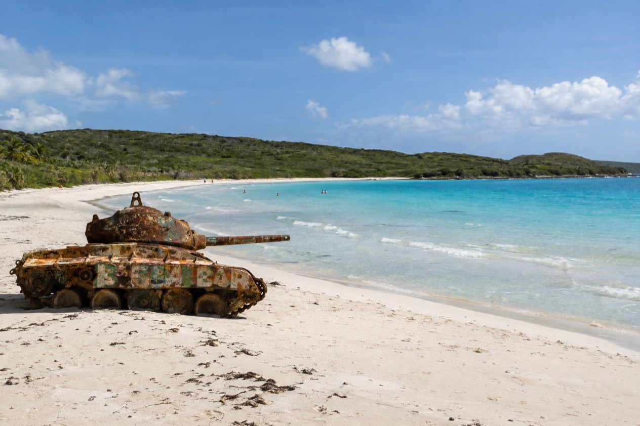
The first thing you notice on the walk down to Flamenco is the color of the water, a pale, clear green that sits over sand almost as light as flour. Then, at the edge of the beach, the rusted military tanks come into view, painted over by decades of salt and graffiti. This is a horseshoe bay inside a wildlife refuge on the small island of Culebra, and a visit here is a full day of swimming, walking and doing very little.
Is visiting Flamenco Beach worth it?
Yes, if you like a beach with a story and a bit of effort to reach it: Flamenco suits couples, families with older kids, snorkelers and anyone who wants a day on soft sand without a resort behind it. It rewards people who are happy to take a ferry, rent a golf cart and keep the schedule loose.
What sets it apart from the other beaches nearby is the setting. The bay curves like a wide horseshoe, the water is shallow and clear, and the land behind it belongs to a federal wildlife refuge, so there are no towers or condos, just scrub, trees and birds overhead.
The tanks left from the days of military training give the sand a surreal look you will not find on the mainland. Tamarindo, on the west side, is the place for turtles over the seagrass, and Zoni, at the eastern end, is quieter and far less visited. Flamenco is the one with the most to look at, and the one most people picture when they think of Culebra.
The island itself is part of the appeal. Culebra has one town, Dewey, a quiet harbor and no large resorts, so the whole trip feels like stepping out of Puerto Rico into a slower place. Flamenco is the highlight of that slower pace, and most visitors spend the best part of a day here without feeling the need to be anywhere else.
What to see at Flamenco Beach
The horseshoe of sand and water
The beach itself is the main show: a wide arc of pale sand around shallow, clear water. Walk the full length of the curve and the view keeps changing, with low green hills on both ends and the open sea in the middle. Early and late in the day the light turns the water several shades of turquoise.
Conditions change from day to day, so look at how the water is behaving before you wade in, and follow any flag, sign or lifeguard instruction where one is present. Bring a mask if you plan to snorkel at nearby Carlos Rosario Beach.
The rusted tanks
The Flamenco Peninsula and the nearby small islands were used for military training until 1975, and the tanks are what remains. They sit on the sand, rusted through and covered in colorful graffiti, and they have become the beach’s best-known sight. Children like to look them over, and photographers like them at golden hour, when the metal glows against the water.
The tanks tell a quick history of the island. In 1976, portions of these lands were transferred to the Commonwealth of Puerto Rico and the U.S. Fish and Wildlife Service, and what was once a firing range became a protected shoreline. Look at them from the sand and let the story sink in as the waves roll in behind.
The refuge and its Sooty Terns
Flamenco lies inside the Culebra National Wildlife Refuge, established in 1909 by President Theodore Roosevelt and the first site in the Caribbean designated as a federal wildlife reserve for native birds. The refuge takes in dry forest, mangroves, quiet lagoons, open grassland and rocky canyons, along with 21 offshore cays.
The Sooty Tern is the refuge’s animal ambassador, and more than 30,000 pairs nest on the Flamenco Peninsula. Binoculars are a good thing to pack for a walk along the edge of the beach.
Carlos Rosario Beach next door
A short walk from Flamenco brings you to Carlos Rosario Beach, a snorkeling beach with a coral reef close to shore. It is smaller and calmer in feel than Flamenco, and a good place to swap sunbathing for a mask and fins for an hour. The coral reef lies close to shore.
Go with a mask already in your bag, and look at the water before you get in, as with any beach here. Many visitors do this stop in the middle of the day, then walk back to Flamenco for lunch and a swim.
Hours, tickets and rules
The public areas and hiking trails of the refuge are open every day of the week during daylight hours, which means you plan your beach day around a morning arrival and an early evening exit. The table lists the refuge’s stated opening hours.
| Site | Open |
|---|---|
| Culebra National Wildlife Refuge public areas and hiking trails (including Flamenco Peninsula) | Every day, 6:00 AM to 6:00 PM |
The refuge protects nesting birds and native habitats, so plan to be out of the public areas by closing time. The refuge can be reached by email at [email protected].
How to get to Flamenco Beach
Flamenco is on Culebra, a small island about 17 miles east of the main island of Puerto Rico, so the trip starts with a crossing. Culebra is reached by public ferry from Ceiba, on the northeast coast of the main island, or by a short flight.
Once you land in Dewey, the island’s only town, you can get around on rented golf carts and bikes to reach the beach and the other bays. The island is small and unhurried, and the ride to Flamenco is part of the experience, with views of the harbor and the hills along the way.
Most people treat the crossing as the start of a day trip or a longer stay. If you are going for just a day, plan around the beach’s daylight hours and leave yourself a comfortable margin at the end of the afternoon to get back to the harbor. If you stay overnight, you can reach the beach early, when the sand is quietest.
When to visit Flamenco Beach
The best time of day is early, soon after the refuge opens, when the sand is nearly empty, the light is soft and the heat has not yet built. By midday the sun is strong and the beach fills with day-trippers, then thins out again in the late afternoon, when the light turns golden on the tanks.
Puerto Rico is warm all year, with a drier season from about December to April and a wetter one from about May to November. The drier months are an easy choice for a beach day. Because the sea stays warm all year, swimming is possible in any month, but conditions vary from day to day.
The Atlantic hurricane season runs from June 1 to November 30, with the peak on September 10 and most activity between mid-August and mid-October. If you travel in that window, follow the National Hurricane Center and local official alerts, since ferry and flight plans can change quickly.
If you can, aim for mid-July, when Culebra celebrates the Virgen del Carmen, patron saint of fishermen, with a procession of boats in the harbor of Dewey. It is a good way to see the island’s own traditions alongside the beach.
Tips for your visit
Bring sunscreen, a hat, water, a mask and a towel, and plan to spend most of a day. There are no large resorts on the island, so it helps to arrive with what you need for the beach and a flexible mind about the rest. Binoculars are a nice addition for the terns.
Combine Flamenco with Carlos Rosario, a short walk away, for a snorkel over the coral. If you have another day, Tamarindo on the west side is the place to look for green sea turtles feeding over the seagrass, and Zoni at the eastern end is long and quiet.
Families will like the shallow, clear water and the tanks, though children should stay close to the shore and under watch, and everyone should follow any flag or sign where one is present. The walk from the road to the sand and along the beach is part of the day, so wear shoes you can take off easily. Plan to leave before the refuge closes.
Good to know before you go
Culebra is a small island with one town, so arrive with the supplies you need for the day. The currency is the U.S. dollar, and U.S. citizens need no passport and no visa. Check ferry or flight plans against the weather, particularly from August through October.
Sources
- U.S. Fish and Wildlife Service, Culebra National Wildlife Refuge (https://www.fws.gov/refuge/culebra), checked October 8, 2026
- NOAA National Hurricane Center, Climatology (https://www.nhc.noaa.gov/climo/), checked October 8, 2026
To plan your stay
- Best Time to Visit Puerto Rico: Dry Season, Hurricane Season, Beaches and Festivals
- Where to Stay in Puerto Rico: San Juan, Rincon, Vieques and the Best Areas for Your Trip
- Getting Around Puerto Rico: Rental Cars, Tolls, Carros Publicos and Ferries to Culebra and Vieques
- Know Before You Go to Puerto Rico: ID, Money, Getting Around and Local Customs