
JAMAICA · THE ROAD TRIP · DRIVE ON THE LEFT
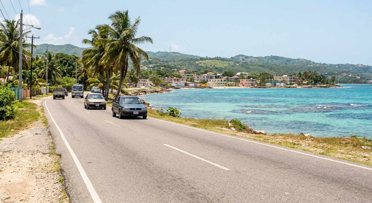
The classic Jamaica road trip runs along the north coast from Negril to Port Antonio, with the sea on one side for most of the drive. Slow down and the south coast opens up: Treasure Beach, the Black River and small guesthouses in fishing villages. Between the two coasts rise the Blue Mountains, green, cool and steep enough to deserve a day of their own.
Jamaica drives on the left. The North-South toll road links Caymanas, just outside Kingston, to Mammee Bay near Ocho Rios in 66.14 km (about 41 miles), and the rest of the trip happens on coast roads and country lanes. Book the first night where your plane lands and build the route outward from there.
THE ROAD TRIP AT A GLANCE · JAMAICA
Choose your arrival airport first, drive the north coast by daylight, and use the North-South toll road as the fast link between Kingston and Ocho Rios.
NORTH COAST · SOUTH COAST · NORTH-SOUTH TOLL ROAD · DRIVE ON THE LEFT
Go for: sea views along the north coast from Negril to Port Antonio, fishing villages and guesthouses on the south coast, and a fast toll-road link between Kingston and Ocho Rios.
Think twice before: driving the Blue Mountains yourself or planning country roads after dark. Many visitors book a local driver for the hairpins and arrive before nightfall.
Law: Road Traffic Act 2018 · Tolls: Toll Authority of Jamaica · Advisory: travel.state.gov · full sources at the end
On this page
- Best road trip route in JamaicaNorth coast, south coast or Blue Mountains
- Driving times around JamaicaMap apps, and the 66.14 km toll road
- Kingston to Ocho Rios toll priceJ$2,500 by car, and paying in a rental
- Montego Bay or Kingston airportMBJ, KIN or OCJ by region
- Is it safe to drive in Jamaica?Level 2, with the Level 3 towns on the coast roads
- Driving with a US licenseHow long it counts, and the JMD 40,000 fine
- Renting a car in JamaicaRental desks, insurance and tolls
Before you set a route, open the Jamaica Tourist Board’s official list of open and closed attractions. It has been kept up to date since Hurricane Melissa, and it is the reference for whether a waterfall, great house or beach park on your list is open. Our guide to Jamaica after Hurricane Melissa covers the recovery.
Best road trip in Jamaica
The north coast is the drive most people picture: Negril, Montego Bay, Falmouth, Ocho Rios and on to Port Antonio, with the sea filling the passenger window as you head east. It suits a first trip, with resort towns to sleep in and beaches to pull over for. Our guides to Negril, Montego Bay, Ocho Rios and Port Antonio cover each stop.
The south coast trades that view for a quieter, less built-up one: Treasure Beach, the Black River and the country around YS Falls. Travelers come here for small guesthouses and fishing villages rather than resorts. Through the windshield you get open shoreline and village streets instead of hotel gates.
The Blue Mountains make the third road, climbing from the Kingston side on narrow, steep lanes full of hairpin bends. They are driven slowly, and many visitors hand the wheel to a local driver or join a tour for the day. Start with our Blue Mountains guide before deciding who drives.
To combine the coast with the mountains, drive from Montego Bay to Ocho Rios along the sea, take the North-South toll road to the Kingston side, and fly home from Kingston. The south coast pairs best with a Negril or Montego Bay start. Our 7-day itinerary and 10-day itinerary set the nights for each version.
How long does it take to drive around Jamaica?
Map apps give town-to-town times live, and those are the figures to use on the morning you leave. The Toll Authority of Jamaica publishes one length: the North-South toll road, 66.14 km (about 41 miles) from Caymanas to Mammee Bay, with an 80 km/h (about 50 mph) limit. At Mammee Bay the toll road meets the coast road, and the pace changes.
Away from the highways, Jamaican roads are often narrow and potholed, shared with pedestrians, route taxis and animals, and the pace runs slower than a map suggests. So set each day by where you sleep: pick tonight’s town, check the live time that morning, and leave room for a beach stop and a long lunch on the way. Our getting-around guide covers the drivers and transfers for the legs you would rather not drive.
How much is the toll from Kingston to Ocho Rios?
A car (Class 1) pays J$2,500 for the full run from Caymanas to Ocho Rios (Mammee Bay), the rate listed by the Toll Authority of Jamaica. The Authority’s page shows no effective date, so check the figure again before you go.
On the North South Highway the speed limit is 80 km/h (about 50 mph). Across Jamaica’s toll highways the posted sign sets the maximum, and where no sign is posted the general limit applies: 80 km/h for cars and motorcycles, 65 km/h for a car towing a trailer. Watch for the signs as you join the road.
Settle the toll question at the rental counter, before you leave the lot. Ask whether the car carries a toll tag, how the company charges crossings and whether it adds a fee of its own. Keep the J$2,500 figure in mind so you can match it against the final bill. Our car rental guide covers the rest of the counter questions.
Should you fly into Montego Bay or Kingston?
Jamaica has three international airports open to visitors: Sangster (MBJ) at Montego Bay, Norman Manley (KIN) at Kingston and Ian Fleming (OCJ) at Boscobel, about twenty minutes from Ocho Rios. Montego Bay is the arrival airport for the resort coast and Negril. For the Blue Mountains, Port Antonio and the east, Kingston is the better fit.
Montego Bay and Kingston sit on opposite sides of the island, and choosing the wrong one costs half a day on the road. Plan by arrival city: land at MBJ for a north coast drive east or a south coast loop out of Negril, land at KIN for the mountains and Port Antonio, and fly into one and out of the other to drive the coast one way. Ian Fleming puts you close to Ocho Rios if your flights serve it.
Is it safe to drive in Jamaica?
The US State Department rates Jamaica Level 2, Exercise increased caution, in an advisory issued June 23, 2026, with some areas listed at Level 3. No area of the island is listed Do Not Travel, and every named area sits at Reconsider travel. Our Jamaica safety guide has the wider picture.
Between Negril and the north coast, the road passes the Green Island Area of Hanover Parish, listed Reconsider travel. Heading south and east out of Negril, the parish town most often crossed is Savanna-la-Mar in Westmoreland, named with Grange Hill at the same level. Drive through by day and keep your stops for the towns you came to see.
Near Ocho Rios, the advisory names Steer Town, in St. Ann’s Parish. Check the route your map app proposes around Ocho Rios and pick an alternative if it runs through Steer Town.
Jamaica drives on the left. The law asks you to keep to the left when another driver overtakes you, and to overtake on the right yourself. Most rental cars have the steering wheel on the right, and roundabouts turn clockwise. On country roads, a short tap of the horn before a blind bend is ordinary Jamaican road manners, so answer in kind and read it as courtesy.
Many visitors time each drive to arrive before dark, since lighting and road markings are sparse on unfamiliar country roads. Check the paperwork too. Driving without motor vehicle insurance is a JMD 20,000 offense, so confirm the rental’s insurance document is in the car before you pull away.
Driving in Jamaica with a US license
A US license counts as a Jamaican one until the earliest of three dates: its own expiry, your departure from Jamaica, or twelve months after arrival, on proof of entry. Keep the document that shows your arrival together with the license. Driving without a valid license or permit is a JMD 40,000 offense with 14 points. With both in the glovebox, the north coast is yours from the first morning: head east out of Montego Bay with the sea at the passenger window and stop at the first beach that tempts you.
Sources & data for this guide
- Foreign license validity (s. 41(3)) and driving on the left, overtaking rules (s. 57(1)(a)-(b)) · Road Traffic Act 2018, Parliament of Jamaica, japarliament.gov.jm · checked Sep 24, 2026
- General speed limits, trailer limit and toll highway rule · Road Traffic Regulations 2022, reg. 229-231 and Twelfth Schedule Part A, japarliament.gov.jm · checked Sep 2026
- Insurance and license fines (codes 83 and 115) · Jamaica Constabulary Force, Offence Codes and Fines 2023, jcf.gov.jm · checked Sep 24, 2026
- North-South toll road length, Class 1 toll and 80 km/h limit · Toll Authority of Jamaica, tollauthority.gov.jm · checked Sep 24, 2026 · the toll page shows no effective date
- US travel advisory, Level 2 issued June 23, 2026, and named Reconsider travel areas · travel.state.gov · checked Sep 24, 2026
- Open and closed attractions since Hurricane Melissa · Jamaica Tourist Board · checked Sep 2026
- Airports and the Ocho Rios distance for OCJ · Ian Fleming International Airport and the MBJ and KIN airport sites · checked Sep 2026
- Driving times between towns · no primary source we could read publishes them, so we point you to live map apps · checked Sep 24, 2026
- Route descriptions, road conditions and airport advice are editorial · check the attraction list and your rental company when you book.
To plan your stay
- Best Time to Visit Jamaica in 2027: Weather, Hurricane Season and Prices, Month by Month
- Where to Stay in Jamaica: Best Areas Compared, All-Inclusive or Not
- Getting Around Jamaica: Route Taxis, the Knutsford Express and Transfers
- Things to Know Before Going to Jamaica: Money Habits, Vendor Etiquette and Local Customs