
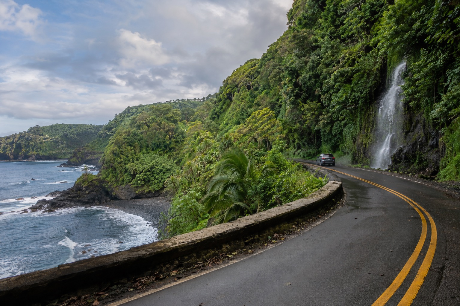
The Hana Highway begins to close in just after Huelo, when the pavement narrows, the jungle leans over the lane and every bend opens onto another stream tumbling toward the sea. Fruit stands appear at the edge of the road, bridges come one after another, and the day slows to the pace of the slowest car. This is Maui’s wet north-east coast, a drive where the journey is the point and Hana town waits at the far end.
Is visiting the Road to Hana worth it?
Yes, if you enjoy a winding drive with plenty of stops and don’t mind sharing a narrow road, because the Road to Hana is less a destination than a full day of waterfalls, rainforest, black sand and fruit stands. It suits travelers who like to look out the window and walk short trails. It suits less anyone who gets carsick or wants a fixed schedule.
Other scenic drives in Hawaii offer a view or two. Here the road itself is the attraction: hundreds of curves, dozens of bridges, many of them one lane wide, and a rainforest that never stays out of sight for long. The state’s bridge plan keeps that low-speed character on purpose, so the slow rhythm is part of the experience.
What to see at the Road to Hana
The Hana Highway itself
The road is a historic district, and the stretch from Hoalua Stream near Huelo to Hana town is the heart of it. Drivers cross dozens of old bridges, some one lane wide, and every curve seems to bring a new view of ferns, ginger, bamboo and the ocean below.
Look for the small fruit stands set along the shoulder, where a pause for banana bread or fresh fruit is part of the tradition. Drivers pull over to let faster local traffic pass and yield at the one-lane bridges. Many stops along the way sit on private land and are not open to visitors, so enjoy those views from the road.
Waianapanapa State Park and Pailoa Beach
Near the end of the highway, Waianapanapa is known for Pailoa, a black sand beach set against dark lava rock, green forest and bright blue water. The contrast of dark sand and tropical green is the picture most people carry home from the day.
Walk the coastline to see sea cliffs and lava formations, and take your time, because the light changes the color of the sand. Valley parking is very limited, which is why the park works on a reservation system. Waves and currents along this coast can be strong, so keep to what the beach signs say.
Kipahulu and the Pipiwai Trail
Beyond Hana town, the Kipahulu District of Haleakala National Park lies 12 miles farther along the coast. It is a quieter, wilder end to the day, with ocean views and a sense of having arrived somewhere remote.
The Kuloa Point Trail leads to views of the Pools of Oheo, which are closed to entry for safety. The Pipiwai Trail climbs through a bamboo forest toward the 400-foot Waimoku Falls, a walk where the bamboo clacks softly overhead in the breeze. There is no gas or food in the park, so arrive with a full tank and your own snacks.
Hana town
Hana is the end of the line and a small, unhurried place of green pastures, ocean views and a handful of shops and stands. It feels far from the resort side of Maui, and that distance is exactly what people come for. Many visitors treat it as a place to stretch their legs, eat something and let the drive settle before deciding whether to continue to Kipahulu or turn back.
Hours, tickets and rules
The road is free to drive, while the two main stops that charge do so differently: Waianapanapa asks for a reservation from everyone, and the national park at Kipahulu charges per vehicle.
| Site | Open | Admission |
|---|---|---|
| Waianapanapa State Park | Daily, 7 a.m. to 6 p.m. | Non-residents: $5 per person and $10 per vehicle for parking, by reservation in time slots |
| Haleakala National Park (Kipahulu District) | Open | $30 per private vehicle, valid three days |
All visitors to Waianapanapa need a reservation, and reservations open up to 30 days ahead on gostateparks.hawaii.gov. Arrive within the first 30 minutes of your slot and leave by its end time. The Pools of Oheo are closed to entry for safety. On the road, pull over for faster local traffic, yield at one-lane bridges and park only where it is legal.
How to get to the Road to Hana
You reach the Road to Hana by driving the Hana Highway, which starts near Huelo on Maui’s north-east coast and ends in Hana town. The highway is narrow and two lanes wide, with more than 600 curves and 59 bridges along the way.
The state’s bridge plan does not allow larger commercial vehicles, so expect to travel in a car or small vehicle. Kipahulu lies 12 miles past Hana town for those who want to continue to the national park.
When to visit the Road to Hana
Waianapanapa opens at 7 a.m., and an early start gives you the quietest road and the freshest light on the black sand. Arrival times are tied to your reserved slot, so plan the day backward from it. Late afternoon is when the lanes fill with cars heading back, and the park closes at 6 p.m.
The drier months run from May to October, when showers are brief and the coast is at its sunniest, though this is still a rainforest and a passing shower is always possible. Winter brings more rainy days and more water in the streams and falls. Hurricane season runs from June 1 to November 30.
Tips for your visit
- Start with a full tank and bring water and snacks, since there is no gas or food in the national park at Kipahulu.
- Pack a light rain jacket, sturdy sandals or walking shoes and a swimsuit for the beach days, keeping to what the signs permit.
- Plan a full day rather than a quick outing, and let the road set the pace.
- Pair the drive with a stop at a roadside fruit stand and a walk at Waianapanapa for a balanced day.
- Families with children and anyone prone to carsickness should plan extra breaks, since the road is nearly all curves.
Good to know before you go
Bring a card and a little cash for fruit stands, and treat the rainforest gently by staying on marked paths and keeping off private land. Hurricane season runs from June 1 to November 30, and showers can arrive on any day of the year along this wet coast.
Sources
- Hawaii DOT, Final Environmental Assessment « Hana Highway Bridge Improvements Project » (Sept. 2024), files.hawaii.gov/dbedt/erp, checked September 25, 2026
- Hawaii DOT, Final EA Hana Highway Bridge Improvements (Sept. 2024), checked September 25, 2026
- Hawaii DLNR Division of State Parks, dlnr.hawaii.gov/dsp/parks/maui/waianapanapa-state-park, checked September 25, 2026
- gostateparks.hawaii.gov/waianapanapa/about, checked September 25, 2026
- Hawaii DLNR Division of State Parks, waianapanapa-state-park, checked September 25, 2026
- National Park Service, nps.gov/hale/planyourvisit/kipahulu.htm, checked September 25, 2026
- National Park Service, nps.gov/hale/planyourvisit/fees.htm, checked September 25, 2026
- NOAA NCEI, monthly normals 1991-2020, station USW00022516, checked September 8, 2026
- NWS Honolulu / Central Pacific Hurricane Center, « 2026 Central Pacific Hurricane Season Outlook », weather.gov/hfo/hurricaneOutlook2026, checked September 24, 2026