
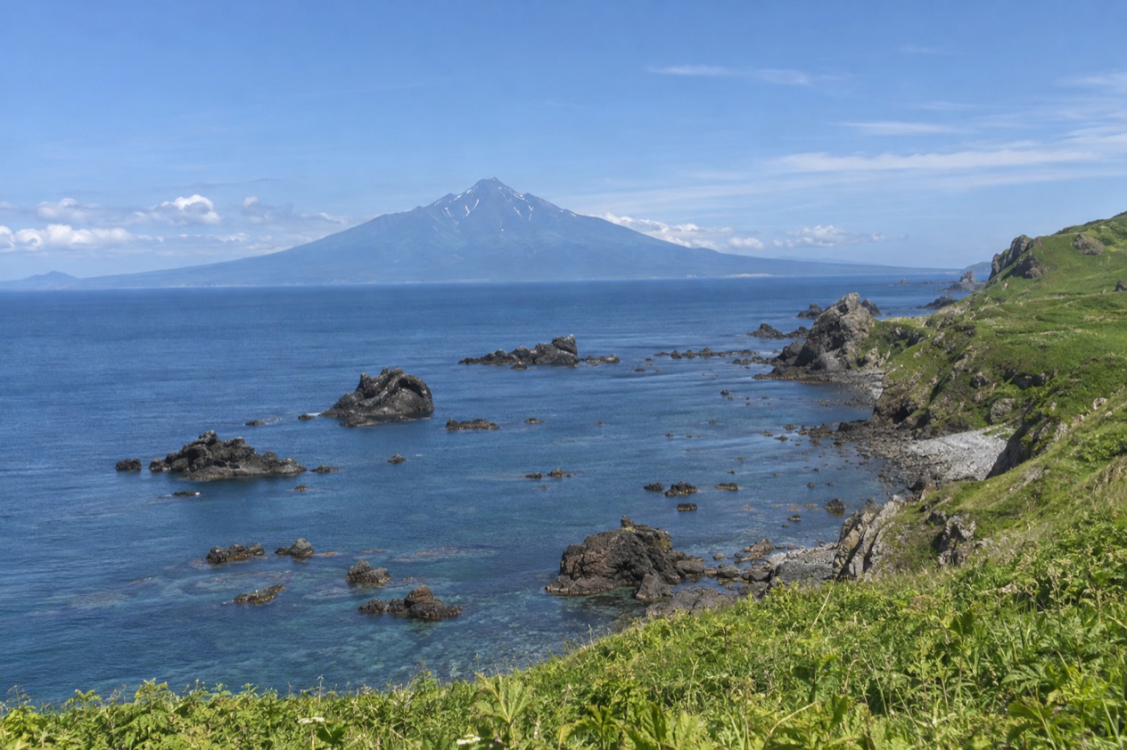
From the ferry deck, Mount Rishiri comes up out of the sea as a single steep cone, and the island seems to be built around it. Rebun lies farther out on the water, lower and longer, and the two islands have been paired in the minds of travelers for as long as the ferries have linked them. This is a visit for people who want a slice of Hokkaido where the sea, the mountain and a national park set the pace.
Is visiting Rishiri and Rebun worth it?
Yes, if what you want from Hokkaido is islands, open water and a landscape dominated by one mountain rather than a list of sights. It suits travelers who like to move slowly, plan their days around ferries and a bus line, and spend their time outdoors or at the table.
What sets these islands apart from the rest of Hokkaido is the sense of having crossed water to get there. The mainland draws visitors for city life in Sapporo, ski resorts around Niseko and the big regional circuits.
Rishiri and Rebun offer something else: a pair of islands that, together with the coastal Sarobetsu Plain, form their own national park, Rishiri-Rebun-Sarobetsu. Rishiri is the round one with the peak, a place to circle by road and bus, looking up at the summit from every side. Rebun is the sister island, reached by another ferry hop, and it gives the visit a second chapter.
Both islands also belong to the Hokkaido that appears in the tourism pitch: seasonal views, trekking, local cuisine and a close relationship with the sea. If you like to arrive somewhere, look at the horizon and let the days unfold around the ferry timetable, it fits well.
What to see at Rishiri and Rebun
The islands are best understood through their shapes: a near-circular island with a volcano at its center, a second island stretched along the sea, and a protected coast tying them to the mainland plain. The figures that frame them are these.
| Feature | Measure |
|---|---|
| Rishiri Island, distance west of Hokkaido | About 12 mi |
| Rebun Island, beyond Rishiri to the northwest | A further 6.2 mi |
| Rishiri Island, north to south | 12 mi |
| Rishiri Island, east to west | 8.7 mi |
| Rishiri Island coastline | 39 mi |
| Mount Rishiri, summit altitude | 5,646 ft |
Mount Rishiri
The mountain is the reason the island looks the way it does. It rises straight from the shoreline to a summit well above five thousand feet, so it is in view from the ferry, from the coastal villages and from most of the road around the island. Because it stands alone, with sea on every side, the cone reads clearly as a single volcano, and its outline changes as you move around its base.
People simply spend their time looking at it: from a window seat on the bus, from a harbor wall, from a table at a seaside restaurant. Hokkaido is known for trekking, and a peak like this naturally draws hikers, though the details of any route, season or permission belong to the local sources rather than to a general description. What you can count on is a skyline that stays with you for the whole visit.
The coast road and the villages
A bus service circumnavigates Rishiri Island, connecting the coastal communities, and that single fact shapes how people see it. The island has a coastline of modest length, and the settlements sit along it like beads, each with its own harbor, fishing boats and drying racks. Riding the loop lets you watch the mountain swing from one side of the window to the other.
Food is part of the scenery here. Rishiri is associated with kombu, the kelp that underpins Japanese broth, and with sea urchin, served in bowls over rice in the island’s small restaurants. Grilled fish and seafood fill out the menus. Eating in a harbor village, with the mountain behind the building, is as close to a signature experience as the island offers.
Rebun Island
Rebun lies to the northwest of Rishiri, a ferry crossing away. It has a different profile: lower, more stretched out, without a dominant cone. Hokkaido’s hiking tradition shows up here as well, and the island is known in Japan for its flowers and its coastal landscapes, which makes it a natural contrast to Rishiri’s mountain-centered scenery.
Think of Rebun as the part of the visit where you shift from looking up to looking out. Plan it as a second base or a separate stop rather than a quick footnote, and use the ferry link between the two islands to join them. Seafood again anchors the table, and the island’s own villages set the rhythm of the day.
Birds and the national park
Rishiri has been recognized as an Important Bird Area by BirdLife International, because it supports populations of black-tailed gulls and Japanese robins. Gulls are an easy companion along any harbor, and anyone who carries binoculars will find the robins a reason to slow down in the island’s wooded stretches.
The national park is the larger frame. Rishiri, Rebun and the coastal Sarobetsu Plain together make up the Rishiri-Rebun-Sarobetsu National Park, which tells you that the protected landscape is a combination of mountain, island coast and flat plain by the sea. It is the right context for a visit built around walking, birdwatching and slow travel.
How to get to Rishiri and Rebun
You reach the islands by ferry, and the ferry network is what ties them to Hokkaido. Service from Rishiri connects to Rebun, to Wakkanai and to Otaru, so the island works as a hub with links in three directions. Rebun, in turn, is the next island over, reached by the Rishiri connection.
For travelers coming from abroad, the route starts in Hokkaido itself. New Chitose Airport, near Sapporo, is the air gateway to the prefecture, and direct flights from Tokyo take about 1 hour 30 minutes. From there, the ferry ports of Wakkanai and Otaru are the places named in the Rishiri service, so the journey becomes a matter of getting from the airport region to one of those ports and boarding.
The rail alternative from Tokyo to Sapporo takes about 8 hours: the JR Tohoku/Hokkaido Shinkansen runs to Shin-Hakodate-Hokuto, and the limited express Hokuto continues to Sapporo. That is a long day, and it puts you in the same part of Hokkaido as the airport route does. Onward details, such as sailing schedules, crossing durations and fares, are not given here, so treat the ferry operators as the source for them.
Once on Rishiri, the bus that circles the island joins the coastal communities, and that is the public way around the island itself. Rebun is reached by the ferry from Rishiri. Together, the two links give a simple outline: arrive on a ferry from Wakkanai or Otaru, circle Rishiri by bus, cross to Rebun, and return the same way.
When to visit Rishiri and Rebun
Hokkaido is the prefecture of seasonal views, and the islands share that identity, so the right moment depends on what you want to see. Trekking and outdoor activities are part of Hokkaido’s appeal, and the islands’ peak and coastal paths fit that theme. Seafood is a draw whenever you arrive, because the islands are tied so closely to fishing and kelp.
A few things are worth knowing about the mainland calendar. Winter in Hokkaido brings the ski season, and the area around Niseko is known as a winter sports center. Sapporo hosts its Snow Festival in the cold months.
Those are mainland events, not island ones, but they show how strongly the seasons shape travel in the prefecture. For Rishiri and Rebun, the choice of season will determine the look of the mountain and the mood of the harbors.
Specific dates, such as when flowers bloom, when the ferries run most often or when the weather is at its mildest, are not given for the islands here, and it would be a mistake to guess. The ferry operators and the local tourism office are the right sources for the sailing season and for what is open at a given time. The useful way to choose is to decide first what you want, mountain views, hiking, birds or seafood, and then to confirm the timing with those sources before you go.
Whatever the month, the shape of the day is set by the ferry and the bus. Build your plan around the crossing, leave room for a harbor lunch, and let the mountain provide the backdrop.
Tips for your visit
Pack for the sea and the mountain together. The islands sit offshore and Mount Rishiri stands alone beside the water, so a visit mixes ferry decks, harbor walks and open coastline. Binoculars are worth bringing for the birds that made the island an Important Bird Area, and a camera suits a mountain that changes its outline from every village.
As for how long to stay, the shape of the trip suggests a minimum of two parts: one for Rishiri, with its loop of coastal communities, and one for Rebun, reached by ferry. A night on each island lets the ferry timing work for you rather than against you.
Combining the islands with the rest of Hokkaido is natural. Sapporo and its surroundings, Asahikawa and northern Hokkaido, Hakodate and southern Hokkaido, and Kushiro and eastern Hokkaido are the regions the prefecture is divided into, and northern Hokkaido is where Wakkanai, the ferry port on the Rishiri service, fits the picture. Otaru, the other mainland port, gives a second way in or out, so you can arrive at one and leave from the other without retracing your steps.
Families and travelers who prefer not to drive can lean on the island bus, which circles Rishiri and connects the coastal communities. Details such as parking, guide services, trail access or any restriction on the mountain are not given here, so they should come from the local sources. What you can plan on is a trip that revolves around the water, the peak and the table.
Good to know before you go
These are working fishing islands, so the best meals are in small harbor restaurants where the catch of the day and the local kelp set the menu. Ferries are the lifeline between Rishiri, Rebun, Wakkanai and Otaru, which means your plans move with the crossings, and the bus around Rishiri is the way the coastal communities stay connected. Weather at sea can change a day, so keep your schedule flexible and leave a margin around the ferry connections that bring you back to the mainland.
Treat the mountain and the coast as protected national park land, and carry out what you carry in. Check the current conditions with the ferry operators and local offices before you travel, since sailing seasons and what is open are theirs to confirm.
Sources
- Wikipedia, Rishiri Island (https://en.wikipedia.org/wiki/Rishiri_Island), checked October 11, 2026
- Japan National Tourism Organization, Hokkaido (https://www.japan.travel/en/destinations/hokkaido/hokkaido/), checked October 11, 2026
- Hokkaido Love, the official Hokkaido tourism site (https://www.visit-hokkaido.jp/en/), checked October 11, 2026
To plan your stay
- Best Time to Visit Japan: Cherry Blossoms, Autumn Colors, Weather and Festivals
- Where to Stay in Japan: Ryokan, Temple Stays, Capsule Hotels and the Best Cities to Base In
- Sending Luggage from the Airport in Japan: Hands-Free Travel, Hotel Delivery and Coin Lockers
- Know Before You Go to Japan: Entry, Money, Etiquette and Getting Around