
You are scrolling through photos of a San Pedro beach or a Placencia shoreline, and one of them shows a brown ribbon of seaweed along the waterline. Sargassum is the question that follows many Belize trip plans. The short answer is yes, it reaches Belize’s coast, it comes and goes in waves rather than staying put, and the country has built a response to it.
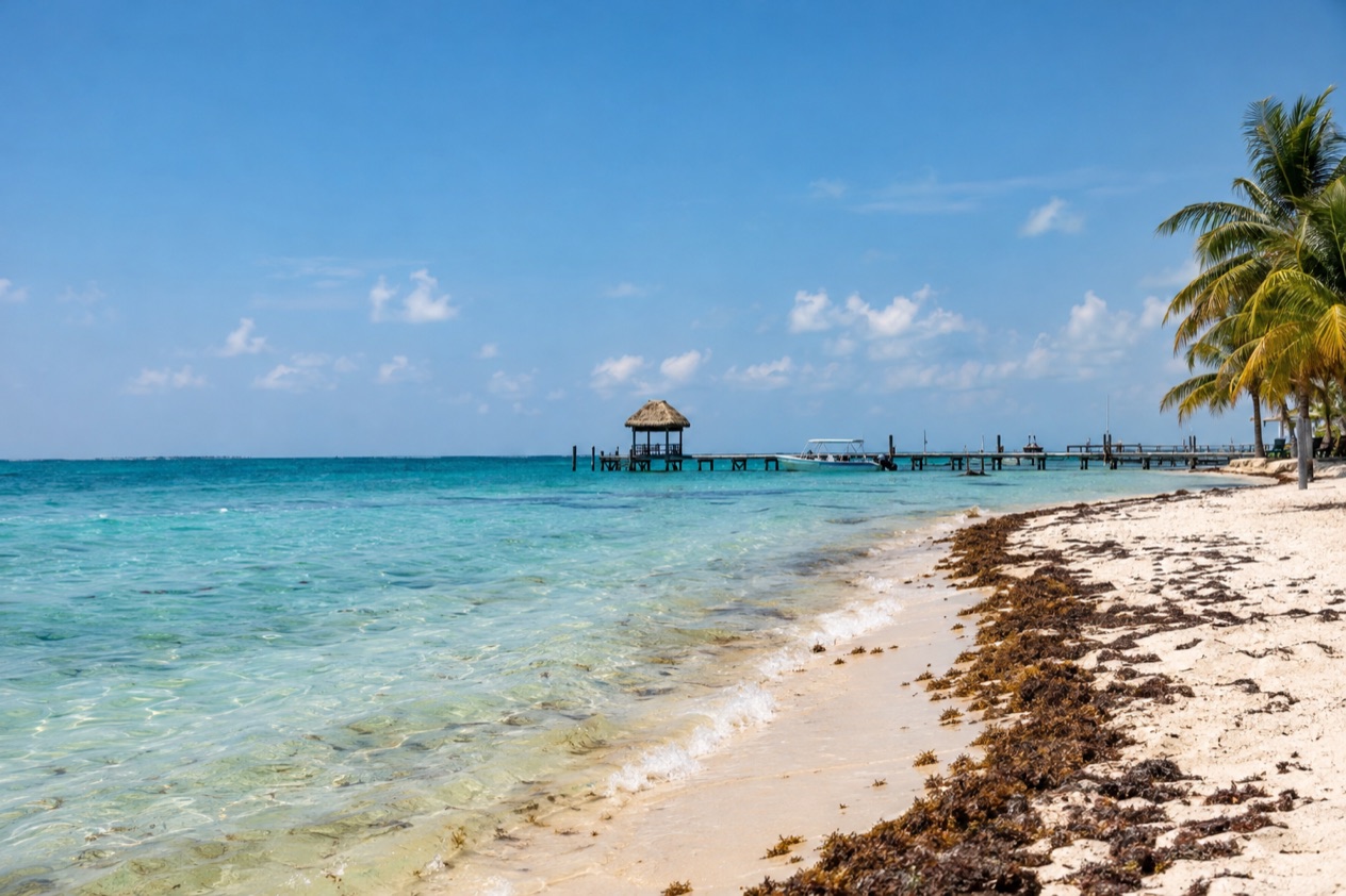
Does Belize have sargassum?
Yes, Belize has sargassum, and the Belize Tourism Board treats it as a direct threat to the tourism industry. Plans to visit San Pedro or Placencia have been derailed or canceled because of the piles and the odor. It is a real feature of the Caribbean coast today, and it helps to know what it is before you picture it.
What it is and where it comes from
Sargassum is a brown algae that floats in clumps that are sometimes a mile long. Out on the water it simply drifts. Once it washes onto a beach and starts to rot, it gives off a smell like rotten eggs, and that smell is what most people notice first, often before they see the seaweed itself.
The first wave reached Caribbean shores in 2011, and it was first believed to have come from the Sargasso Sea in the Atlantic. Satellite images later showed something larger.
Sargassum was blooming off the coast of Brazil and stretching across to Africa and back, and the currents were pushing it into the Caribbean. Belize sits at the end of that long drift, which is why a problem born in the open Atlantic ends up on a caye.
What the country does about it
Belize has set up a Sargassum Task Force, and it has produced practical tools. One is a local forecasting system, built with the Meteorological Service, that supports weekly and daily sargassum forecasts for the country. Another is municipal relief support, which covers the containment, collection and disposal of the seaweed in five destinations. Tax relief has helped too: coastal hotels received a credit of 2% from the hotel tax in 2018 and 2019.
The cleanup follows rules meant to protect the beach itself. Local governments and destination managers are told to use manual labor and light machinery, so the sand, the beach and the marine life are disturbed as little as possible, and heavy machinery is not to be used on the beach.
Beachfront properties are told not to let the seaweed pile up for more than 48 hours and to pull it from the water as soon as they can. A resort that rakes its shoreline every morning is following that guidance.
Tourism businesses that decide to install barriers, called booms, or other diversion equipment are directed to the Department of Environment for the approval process. The Sargassum Task Force has also lobbied for a duty exemption for businesses importing equipment, materials or technology for cleaning. Together these measures show a country working on the problem rather than hoping it passes.
What to do if you meet it
The guidance for travelers is simple: if sargassum has accumulated along the shoreline, avoid swimming in the affected area. Walk the sand, watch the water, take a boat trip or spend the hours at a pool or on a dock instead. A stretch of shore that is clogged one day can look different after the next round of clearing.
Belizean tourism providers are also advised to recommend a certified medical practitioner to any guest who reports difficulty breathing, skin rashes or dizziness. If you feel any of those symptoms near rotting seaweed, that is the advice to follow. Otherwise, the seaweed is mostly a matter of smell, sight and where you choose to spend your beach time.
Where does it reach the coast?
It reaches the Caribbean side of Belize, and the municipal cleanup support names five places where the work is organized: San Pedro on Ambergris Caye, Caye Caulker, Hopkins, Seine Bight and Placencia. That list spans the cayes in the north and the long peninsula in the south, so the seaweed is not a problem of one beach.
San Pedro and Ambergris Caye
San Pedro is a town on the southern part of Ambergris Caye, in the Belize District. It is the place most closely tied to the reef: the San Pedro Barrier Reef is described as the second largest in the world after the Great Barrier Reef, and the protected areas of Hol Chan Marine Reserve, Shark Ray Alley and Bacalar Chico are part of the town’s draw. Many of the reasons to come here, from snorkeling to diving, sit out on the water.
That matters when you think about sargassum. The shoreline in town is only one part of an Ambergris Caye stay.
The north road, which runs for more than ten miles, has opened up resort and beach house development with better access than only watercraft, so you can choose where along the island to base yourself. Because San Pedro is one of the places named in the cleanup support, a seaweed day in town is something the local authorities are prepared to handle.
Placencia and the peninsula
Placencia is a small village in the Stann Creek District, at the southern end of a peninsula that is 18 miles long. From north to south, the peninsula holds Riversdale Village, Maya Beach Village, Seine Bight and Placencia Village. Seine Bight and Placencia are both on the list of places with municipal relief support, which puts the southern half of the peninsula in the cleanup system.
Maya Beach Village is a tiny community midway between Placencia Village and Riversdale, about a mile and a half long, with homes, small resorts, two small grocery stores, a half dozen bars and restaurants and an art gallery. It is a quiet base, and a day spent there can include a walk along its shore.
A Placencia stay does not depend on the beach alone. The village offers kayaking, snorkeling, diving, saltwater fly fishing, light tackle fishing, restaurants and local art galleries. Placencia Lagoon has manatees, dolphins, rays and mangrove forests, and you can go birding there by canoe or kayak.
Inland, Cockscomb Basin Wildlife Sanctuary is a day trip from Placencia, and so are the Maya ruins of Nim Li Punit and Lubaantun in the Toledo District. If the shore is covered, there is plenty to do away from it.
Caye Caulker and Hopkins
Caye Caulker and Hopkins complete the list of destinations with municipal relief support. They are two very different places, one a small caye and the other a village on the mainland coast, and both are covered by the same arrangement for containing, collecting and disposing of the seaweed.
What that means for you is practical. On any of these five shores, a pile on the sand is a temporary problem with a crew assigned to it. Wherever you stay, a hotel on the water is expected to keep its own frontage clear, and the same advice applies everywhere: if the seaweed has gathered at the water’s edge, stay out of the water there and enjoy the place another way.
When is it worst?
The worst days are the ones when currents push big clumps onto a shore and the piles sit on the sand while the smell rises, and that can change from one week to the next. Sargassum arrives in bouts rather than on a fixed calendar, which is why Belize built a forecast in the first place.
Reading the forecast
The Sargassum Task Force developed a local forecasting mechanism with the Meteorological Service, and it supports weekly and daily forecasts for the country. That is a more useful tool than any general rule about a month. The weekly outlook gives a sense of the coming days, and the daily forecast tells you what the coast looks like right now.
The first wave in 2011 and the larger blooms seen from satellites in 2015 show how the seaweed behaves: it is carried by currents across a huge stretch of ocean, and it lands where those currents take it. The point for a traveler is to stay flexible about which hours, which beach and which day you give to the shoreline.
The sea through the year
The water around both San Pedro and Placencia is warm in every season, and it grows warmer from the start of the year into autumn.
| Month | Sea near San Pedro (°F) | Sea near Placencia (°F) |
|---|---|---|
| January | 81.4 | 81.0 |
| April | 82.6 | 84.3 |
| July | 85.7 | 86.4 |
| October | 86.5 | 87.1 |
In January the sea is a little cooler, and by October it is at its warmest. For a traveler, warm water means a long season for snorkeling, diving and boat days, whatever is happening along the sand.
Planning around it
Think of the shoreline as one part of a trip rather than all of it. In San Pedro, the reef, Hol Chan, Shark Ray Alley and Bacalar Chico are out on the water. In Placencia, whale shark watching takes place during the full moons between April and July, and the lagoon, the kayaking and the day trips to Cockscomb Basin or the Maya ruins fill days that have nothing to do with the beach.
If you are weighing a trip, the forecast is the tool to use close to your dates, and a flexible plan is the best protection. Spend a seaweed morning in the lagoon or on a day trip, and come back to the beach once the crews have been through. Placencia also hosts the Lobster Fest, the Peninsula Arts Festival and Easter Week celebrations, and San Pedro holds El Gran Carnaval, so a stay can be built around events as much as around the sand.
Good to know before you go
The U.S. State Department rates Belize Level 2, “Exercise increased caution”, because of crime, and says the south side of Belize City has historically had the highest concentration of violent crime.
The Atlantic hurricane season runs from June through the end of November, which covers the autumn months, so it is part of the picture for a Caribbean-coast trip alongside sargassum. Seaweed and storms are separate questions, and each deserves its own look when you set dates. Keep your plans flexible for the shore, use the daily forecast when you arrive, and keep the reef, the lagoon and the inland sites in mind as the days you can count on whatever the beach looks like.
Sources
- Belize Tourism Board, Sargassum resource (https://www.belizetourismboard.org/tourism-resources/sargassum-resource/), checked October 11, 2026
- Wikipedia, San Pedro Town (https://en.wikipedia.org/wiki/San_Pedro_Town), checked October 11, 2026
- Wikipedia, Placencia (https://en.wikipedia.org/wiki/Placencia), checked October 11, 2026
- Open-Meteo Marine API, average 2015-2024, checked October 11, 2026
- U.S. Department of State, Belize Travel Advisory, Level 2, March 11, 2026 (https://travel.state.gov/), checked October 11, 2026
- NOAA National Hurricane Center, Climatology (https://www.nhc.noaa.gov/climo/), checked October 11, 2026