
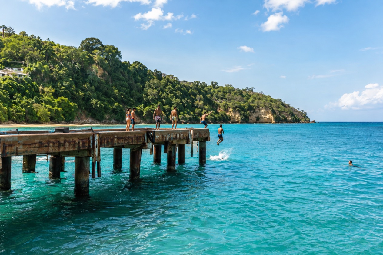
The first thing you notice at Crash Boat Beach is the remains of the old pier stretching out over the water. Fishermen use the pier, and the whole scene has the easygoing look of a local hangout rather than a resort strip. It is a beach visit with a bit of history attached, on the northwestern coast of Puerto Rico in Aguadilla.
Is visiting Crash Boat Beach, Aguadilla worth it?
Yes, especially if you like a beach with character: a place where you can swim, snorkel, sunbathe or just watch the pier life unfold, and where the setting tells a story about the island’s military past. It suits travelers who prefer a lived-in spot over a polished one, and it works as a half day or as one stop in a longer tour of the northwest.
What sets it apart from other beaches along this coast is the pier. Aguadilla counts dozens of beaches, and many of them are about surf, rocks or quiet stretches of sand.
Crash Boat is the one with a landmark you can point to, the remains of a structure built for rescue boats, which now serve as a jumping platform, a fishing perch and a photo backdrop. The beach also sits between the old Ramey air base and the town of Aguadilla, so it feels connected to both the history and the everyday life around it.
Visitors can swim, sunbathe, surf and snorkel here, which makes it a good all-around choice for a group with different tastes. At Crash Boat Beach in Aguadilla, one person can float with a mask, another can relax on the sand, and a third can watch the fishermen bring in their catch. If you only have time for one beach in Aguadilla and want something with a story, this is a natural pick.
What to see at Crash Boat Beach, Aguadilla
The pier and its military story
The beach takes its name from the U.S. military rescue boats that used this pier to reach downed airmen from Ramey Air Force Base. They were the crash boats of the name, ready to speed out when an aircraft went down. The pier was built for that purpose, and you can still see the remains of the infrastructure that once supported the base.
Over time, sand deposits built up and formed a beach, and the pier became unusable for docking. Today the remains serve as a fishing and recreation spot. Early in the day is a pleasant time to see fishermen working from the structure before the beach fills.
The sand and the water
The beach itself is a long, gently curving strip, with clear water that invites swimming and snorkeling. Look down from the pier and you often see the sandy bottom and fish moving below. Conditions change from day to day, as they do on any Atlantic-facing coast, so watch the water before you go in and follow any flag, sign or lifeguard instructions if they are present.
Surfers also use the area, a fitting detail for a municipality that hosted the ISA World Championship surfing competition in 1988. Even if you stay on the sand, watching the water is part of the pleasure. Sunbathers tend to settle along the shore, while snorkelers drift near the pier.
Between Ramey and Aguadilla
The beach lies halfway between the former Ramey Air Force Base and the town of Aguadilla. The base is now the site of Rafael Hernández International Airport, handed over to the Government of Puerto Rico in 1973, and the Coast Guard still has an air station there. Planes passing overhead are a small reminder of why the pier existed.
Aguadilla itself, nicknamed the Garden of the Atlantic, was founded in 1775. If you have time, the town makes a natural companion to the beach, with its own waterfront and local food. The mix of beach, aviation history and town life gives the stop more depth than a simple swim.
Hours, tickets and rules
Crash Boat has an open, informal feel. What you can count on is the setting: sand, water and the old pier, available for swimming, sunbathing, surfing and snorkeling.
| Site | Open |
|---|---|
| Crash Boat Beach | Beach and pier area, daytime visits |
Where a flag, sign or lifeguard is present, follow it, and remember that sea conditions vary from one day to the next.
How to get to Crash Boat Beach, Aguadilla
Crash Boat Beach is on the northwestern coast, in the municipality of Aguadilla, halfway between the town and the former Ramey Air Force Base. That location makes it easy to place on a map: look for the stretch between the airport and the town center.
The closest major gateway is Rafael Hernández International Airport, also in Aguadilla. It is reached by two highways from PR-2, the main road along this coast, which also helps orient you for the beach, since the beach lies between the airport area and the town. If you land here, the beach is a short hop within the same municipality.
For travelers staying in Aguadilla, the beach is part of the local geography rather than a far-off excursion. From elsewhere on the island, plan to head toward the northwest coast and aim for Aguadilla, then follow signs or your map toward the beach between the town and the airport.
When to visit Crash Boat Beach, Aguadilla
Morning is a lovely time at the pier. The light is soft, fishermen are at work, and the beach has a quieter feel before families arrive. Midday brings the full beach scene, with swimmers, snorkelers and kids jumping from the pier, while late afternoon gives a warm light over the water and a relaxed mood as the day winds down.
Puerto Rico is warm and humid all year, with a drier season from about December to April and a wetter one from about May to November. Winter can bring bigger swells, which surfers enjoy and swimmers should respect. Summer tends to be the season for calmer, snorkel-friendly days, though conditions change from day to day and beach to beach.
The Atlantic hurricane season runs from June 1 to November 30, with the peak around September 10 and most activity between mid-August and mid-October. If you travel in those months, follow the National Hurricane Center and local official alerts.
Local events can add color to a visit. The Kite Festival is held in Aguadilla in April, with kiosks, music and kite flying. The Festival del Atún, dedicated to tuna fishing, takes place in July. The patron saint festival, Fiestas Patronales de San Carlos Borromeo, comes in October with parades, games, artisans, regional food and live entertainment.
Tips for your visit
Bring a mask and snorkel if you have them, since the water near the pier is one of the draws. Pack sunscreen, a hat, a towel and water, and wear sandals you do not mind getting wet. A camera or phone is handy for the pier, which is the most photographed spot on the beach.
Plan a relaxed half day. That gives you time to swim, walk out on the pier, watch the fishermen and perhaps have a snack from the vendors who set up nearby. If you like to move at a slow pace, linger until the afternoon light softens the whole bay.
The beach combines easily with other Aguadilla stops. The town has nine places on the U.S. National Register of Historic Places, and it is home to the only ice skating complex in the Caribbean, the Aguadilla Ice Skating Arena, a surprising contrast to a day on the sand. Aguadilla has 32 beaches in all, so if the mood strikes you can explore another stretch of coast the same day.
Families will find plenty to enjoy, from sand play to watching others leap from the pier. Keep a close eye on children near the water and the pier edge, and follow any flags or signs. Anyone with limited mobility should expect sand and a weathered pier, and can still enjoy the view from the shore.
Good to know before you go
Puerto Rico uses the U.S. dollar, and U.S. citizens need no passport and no visa. Sun and heat are the main habits to plan for, so drink water and reapply sunscreen. Respect the sea, watch the conditions and follow any flag, sign or lifeguard where one is present. The hurricane season runs from June 1 to November 30, so keep an eye on official forecasts if you travel then.
Sources
- Wikipedia, Crash Boat Beach (https://en.wikipedia.org/wiki/Crash_Boat_Beach), checked October 8, 2026
- Wikipedia, Aguadilla (https://en.wikipedia.org/wiki/Aguadilla,_Puerto_Rico), checked October 8, 2026
- Wikipedia, Rafael Hernández Airport (Aguadilla) (https://en.wikipedia.org/wiki/Rafael_Hernández_Airport), checked October 8, 2026
- NOAA National Hurricane Center, Climatology (https://www.nhc.noaa.gov/climo/), checked October 8, 2026
To plan your stay
- Best Time to Visit Puerto Rico: Dry Season, Hurricane Season, Beaches and Festivals
- Where to Stay in Puerto Rico: San Juan, Rincon, Vieques and the Best Areas for Your Trip
- Getting Around Puerto Rico: Rental Cars, Tolls, Carros Publicos and Ferries to Culebra and Vieques
- Know Before You Go to Puerto Rico: ID, Money, Getting Around and Local Customs