
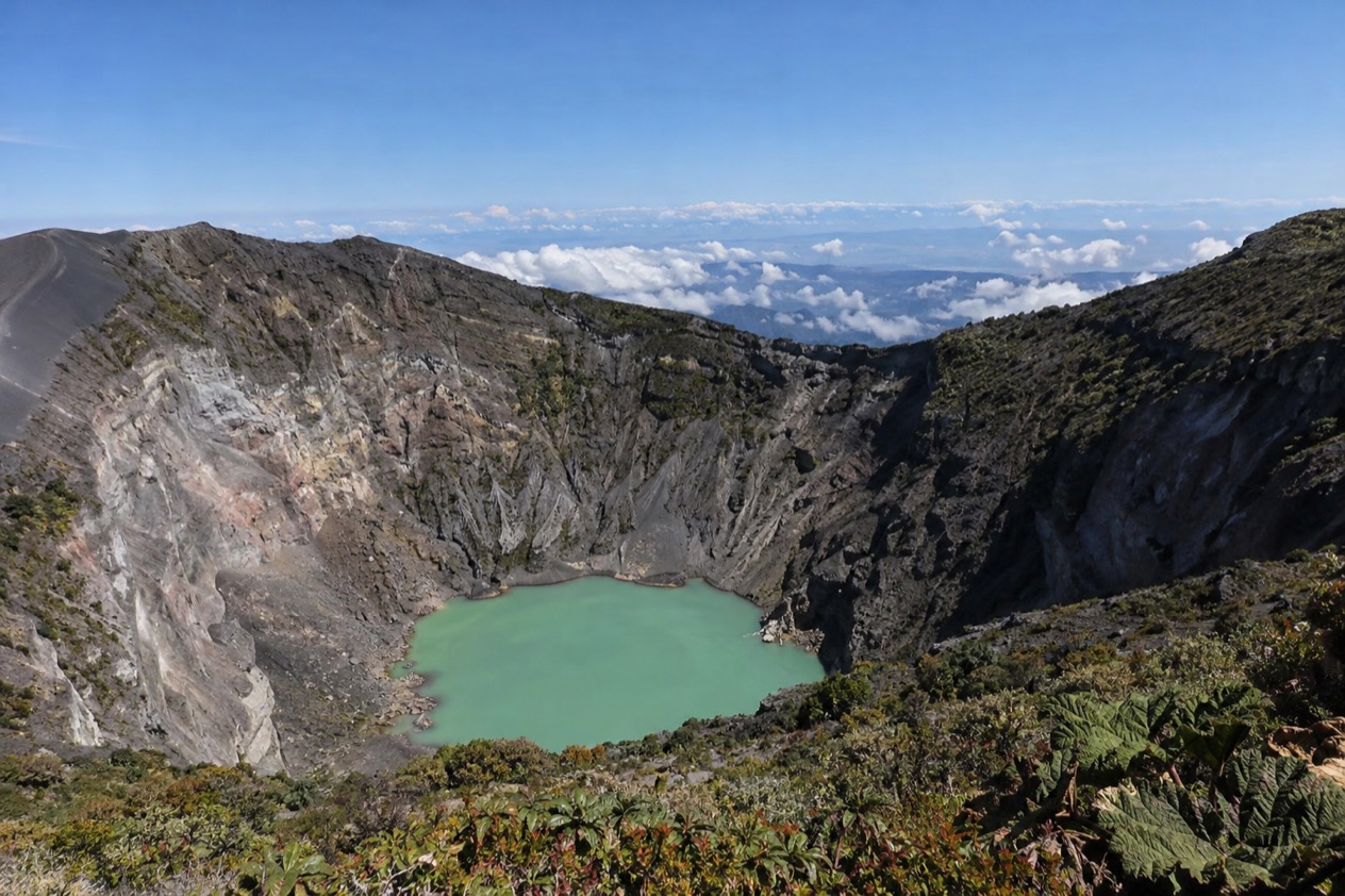
Near the top of Irazu, the air turns thin and cold, the clouds drift across a landscape of gray ash and black rock, and on a clear morning a green lake sits at the bottom of a deep crater. Sometimes the cloud rolls in and swallows it all within minutes. This is the tallest volcano in Costa Rica, reached from Cartago by a road that climbs almost to the rim, and it suits travelers who want a big, otherworldly view without a long hike.
Is visiting Irazu Volcano worth it?
Yes, for anyone staying in the Central Valley who wants to stand beside an active volcano with little effort, and especially for families, photographers and travelers who prefer a half-day outing to a full day of trekking. The crater can be reached easily, the park has a cafeteria, restrooms and viewpoints, and the scenery looks nothing like the green countryside below.
What sets Irazu apart from other volcano visits is how close it is to the capital and how little stands between you and the rim. Many volcanoes in the country are seen from a distance or from a hot spring terrace, while here you walk right up to the edge of a crater with a long history of eruptions. The summit is the highest point in the country’s volcano country, and the Sapper formation is described as the highest point from which both coasts can be seen, though clouds often decide whether anyone sees anything at all.
The trade-off is the weather. Up here it can be cold, windy and gray even when San Jose is sunny, and the lake may be hidden. Go expecting a chance of a spectacular view, and a pleasant, strange walk in any case.
What to see at Irazu Volcano
The Principal Crater and its lake
The Principal Crater is the heart of the visit, a wide pit with steep, pale walls streaked in rust and gray. On clear days a green lake fills the bottom, its color shifting with the light and the minerals in the water. The park describes the crater as easy to reach, though the altitude can make you breathe harder than you expect.
Look for the barren ground around the rim, where little grows except hardy mountain plants that cling to the ash. The volcano has a long history of eruptions, and the lunar look of the slopes is a reminder that this is an active mountain, not a postcard backdrop. Stay on the marked paths and use the viewpoints along the way.
Diego de la Haya and the other craters
Beside the main crater lies the Diego de la Haya crater, along with the one named Hermosa Beach. They are quieter than the Principal Crater, with their own colors and shapes, and they give the walk a sense of a whole summit complex rather than a single hole in the ground.
Take your time at the signs and viewpoints. Photographers like the mornings, when the light is softer on the rock, but clouds can change the picture in a few minutes, so patience pays off more than planning.
The Sapper formation and the two-coast view
The Sapper formation is the highest point on the volcano, and it is known as the place from which both the Pacific and the Caribbean can be seen. That is a chance, not a promise: it takes an unusually clear day, and most visitors see a sea of cloud or a patch of valley instead.
Even without the grand panorama, the feeling of standing at the top of the volcano is memorable. Bring a layer, because the wind at this height cuts through light clothing.
The Prusia Sector
Prusia is the quieter side of the park, a separate sector away from the crater area, reached by turning left before Tierra Blanca and following an access road for a stretch that is in bad condition. Plan extra time for the approach, and go in a vehicle that handles rough surfaces patiently.
It suits travelers who prefer a calmer, less visited part of the mountain and don’t mind a slower drive. Online reservation is required for this sector, so arrange it before you set out, because there is no point discovering that at the gate.
Hours, tickets and rules
The park keeps the same schedule every day of the week, holidays included, and closes in mid-afternoon, so the visit belongs to the morning and early afternoon. Entry tickets are bought and reserved online, and the two sectors of the park both require that reservation.
| Site | Open | How to book |
|---|---|---|
| Parque Nacional Volcán Irazú (Sector Cráteres) | Every day, 8:00 a.m. to 3:30 p.m., including holidays | Online reservation required |
| Sector Prusia | Every day, 8:00 a.m. to 3:30 p.m., including holidays | Online reservation required |
Tickets for the park are sold through the national parks online service run by SINAC. For hiking in national parks, the rule is to register with the park, hold an entry permit and use a certified tour operator, and the Costa Rica Tourism Institute keeps a list of certified tour guides.
How to get to Irazu Volcano
From San Jose, the drive to the volcano takes about an hour and a half, climbing through Cartago and the highland farms above it. The road winds up through dairy country and vegetable fields before the landscape opens into the bare, ashy summit zone, and the temperature drops with every curve.
A bus leaves San Jose daily at 8 a.m. from 2nd Avenue, between 1st and 3rd streets, in front of Hotel Costa Rica. That makes it a simple option for travelers without a car, and the early departure puts you on the mountain soon after the park opens.
If you head for the Prusia Sector, the turn comes 1.2 miles before Tierra Blanca, followed by roughly 2.5 miles on an access road in bad condition. Allow more time than the distance suggests. Parking is available at the park, and the crater is a short way from it, which keeps the logistics easy once you arrive.
When to visit Irazu Volcano
The park opens at 8:00 a.m. and closes at 3:30 p.m., and the early hours are the best bet. At the summit, conditions can be cold and windy, and clear views are never guaranteed. Mornings are also cooler and often calmer for the walk.
The seasons in the valley below shape the odds. January and April are the drier part of the year in San Jose, with fewer rainy days, and the table of weather there shows about seven rain days in January and ten in April.
July is much wetter, with rain on most days, and October is wetter still, with rain on nearly every day and some heavy downpours. In the wetter months, mornings are your window, because showers usually arrive later.
At the summit, conditions are their own story. It can be cold and windy in any month, and a clear sky in the valley guarantees nothing at the crater. The park has a cafeteria.
Tips for your visit
Dress in layers, including a windproof jacket, a hat and closed shoes, since the summit is cold and the ground is loose and rocky. Sunscreen and sunglasses matter too, because the sun is strong at this height even when it feels cool. Bring water, and take it slowly on the short walks, as the altitude is real.
Plan a half-day for the volcano itself, with the drive on either side. The park has a ranger station, information, restrooms, signage, a cafeteria and several natural viewpoints, so you can take breaks without leaving. Families with children and travelers who prefer easy walking will find the crater approach manageable, though anyone with breathing difficulties should go gently in the thin air.
Because the visit ends by mid-afternoon, a morning start leaves room to pair it with Cartago and the highland towns on the way back. Arrive with a reservation in hand and a bit of patience for the clouds, and the outing tends to go smoothly.
Good to know before you go
The U.S. State Department rates Costa Rica Level 2, ‘Exercise increased caution,’ due to crime; it says petty crime is common throughout Costa Rica and that violent crime also affects tourists, including armed robbery, homicide and sexual assault.
The summit sits at about 11,260 feet, so expect thinner air, cold wind and quickly changing weather even on a sunny day in the valley. Keep your belongings with you and in sight at the parking area, as petty crime is common across the country.
Sources
- Costa Rica Tourism Board (ICT), Irazu Volcano National Park (https://visitcostarica.com/where-to-go/protected-areas/irazu-volcano-national-park), checked October 8, 2026
- SINAC (Costa Rica national parks authority), online reservations (https://www.sinac.go.cr/ES/resvlinea/Paginas/default.aspx), checked October 8, 2026
- Open-Meteo / ECMWF ERA5, normals 1991-2020 computed for the grid cell at 9.9281N 84.0907W, checked October 8, 2026
- U.S. Department of State, Costa Rica Travel Information, Safety and security (https://travel.state.gov/content/travel/en/international-travel/International-Travel-Country-Information-Pages/CostaRica.html), checked October 8, 2026
- U.S. Department of State, Costa Rica Travel Advisory, issued April 1, 2026 (https://travel.state.gov/content/travel/en/traveladvisories/traveladvisories/costa-rica-travel-advisory.html), read via the State Department open data API on October 8, 2026
To plan your stay
- Best Time to Visit Costa Rica: Dry and Green Seasons, Weather by Region and Festivals
- Where to Stay in Costa Rica: Beach Towns, Cloud Forest, Volcano Views and Which Base Fits Your Trip
- Costa Rica Airports: San Jose or Liberia? Beaches, Drive Times and Getting to Your Hotel
- Know Before You Go to Costa Rica: Entry Rules, Money, Getting Around and Local Customs