
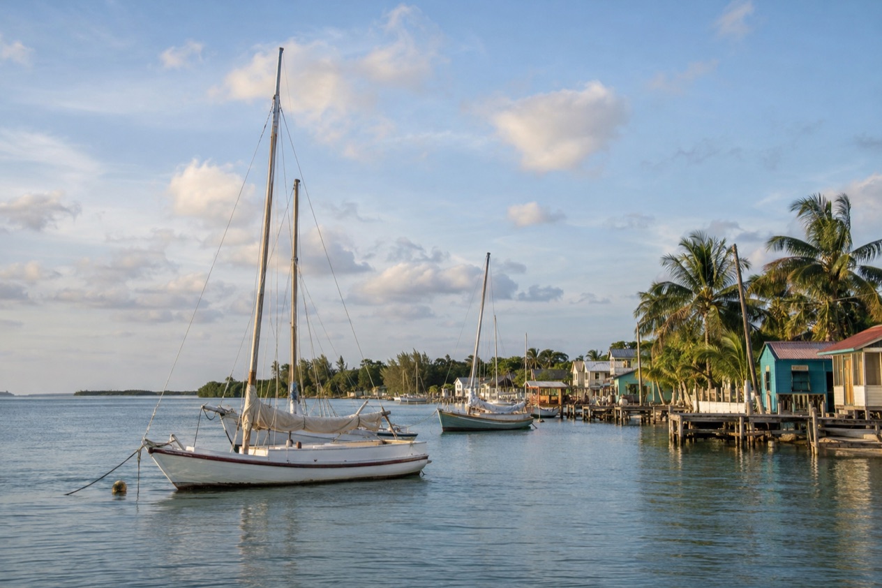
Along the Sarteneja shore, wooden boats sit at their moorings while fishermen sort the day’s catch on the dock, and the talk is a mix of Spanish, Kriol and English. Behind the waterfront, sandy streets run between low houses and the church that stood when everything else was swept away. This is a working fishing village in Northern Belize, for travelers who prefer a place that lives by the sea over one built around visitors.
Where is Sarteneja and what is it like?
Sarteneja is a small coastal village in Northern Belize, on the Sarteneja Peninsula at the mouth of the Bay of Chetumal, and it is a fishing community first and everything else second. It is the largest fishing community in the country and the second largest village, with a population estimated at 3,500 in 2016. That is big enough to feel like a real town, with shops, a church and a busy waterfront, and small enough that you will quickly recognize the faces on the street.
The name has a Maya root. It is a Castilian version of Tza-ten-a-ha, rendered as water between the rocks, and it points to the many wells found across the area.
Water is the thread running through the place: the bay on one side, the wells in the limestone underfoot, and a living that comes almost entirely from the sea. The village has lived this way for generations, and it shows in how the day is organized around the boats.
The pace is slow, and that is the point. Sarteneja sits away from the main tourist crowds, so there is no strip of souvenir stands and no nightlife scene. You come for the waterfront at dawn, the boats, the forest reserve nearby and the feeling of ordinary life in Belize. Its history gives it a certain stubbornness too.
A hurricane destroyed the village in 1956 and only the church was spared, since the earlier lightweight huts were no match for the storm. Running water and electricity arrived in the 1970s, and telephone service came in 1990, so this is a place that has been rebuilt and modernized within living memory.
Who will love it? Travelers who like to walk a village, watch work being done and eat what was caught nearby. Birders and nature lovers drawn to the peninsula’s protected land will find a base here. Who may not? Anyone who wants resort amenities, a lively beach bar scene or a long list of organized attractions. Sarteneja rewards curiosity and a relaxed schedule more than a checklist.
What is there to do in Sarteneja?
The main things to do in Sarteneja are to spend time on the fishing waterfront, explore the protected forest next door at Shipstern, and use the village as a quiet starting point for northern Belize. What sets it apart from its neighbors is that nothing here is staged. The village does not perform for visitors, so what you see is the working rhythm of a fishing town.
The waterfront and the fishing fleet
The shore is the village’s living room. Boats come and go, nets are mended, and the catch is cleaned and sold with the quiet efficiency of people who do it every day. Sarteneja has long been known for its wooden sailing boats and the skill of its boatbuilders, and even a casual stroll along the water shows you hulls in every stage of care.
Walk it early, when the activity is at its busiest, and again toward evening when the light softens over the bay. Between those hours the village slows down, so it is a good time to wander the sandy side streets and notice the small details: painted wooden houses, a shop with a few plastic chairs outside, children on bicycles. Sit down for a meal built around fish and seafood and you are tasting the village’s main trade.
Shipstern Conservation and Management Area
Sarteneja is near the privately owned Shipstern Conservation & Management Area, a protected tract of the peninsula’s natural landscape. The country here is a mosaic of forest, wetland and lagoon, the kind of habitat where you may spot birds, butterflies and other wildlife if you move quietly and look closely.
It suits travelers who enjoy nature on its own terms, without a theme-park feel. Bring binoculars if you have them, since much of what lives in this kind of terrain is easier to hear than to see. Because Shipstern is privately managed, plan the visit as a nature outing and let the landscape set the pace, rather than expecting a long list of attractions.
The wider north: Maya sites and protected waters
Sarteneja also puts you in reach of the north’s other draws. In Corozal District, to the northwest, pre-Columbian Maya ruins stand at Santa Rita near Corozal Town and at Cerros, facing the bay. Corozal is the northernmost district of Belize, and its history of Maya trade and settlement along this coast makes those ruins a natural complement to a fishing village stay.
Farther out, Bacalar Chico National Park and Marine Reserve occupies the northern end of Ambergris Caye, reaching from Chetumal Bay in the west to the Caribbean Sea in the east. It is one of seven sites within the Belize Barrier Reef System UNESCO World Heritage Site. Together these places show how much lies in the quiet north beyond the better-known cayes.
How many days do you need in Sarteneja?
A couple of nights is enough to feel Sarteneja, and a few more let you slow down into it. The village does not reward rushing, since its appeal is in the repeated small pleasures: a waterfront walk at first light, a fish dinner, the quiet after dark, and a nature outing in between.
With a short stay, give one morning to the waterfront and the streets behind it, then spend time at Shipstern and its surrounding forest and wetland. That already covers the village’s two big reasons to visit. Leave the rest of the time open for sitting, watching the boats and talking with people, which is how the place shows itself best.
With more time, Sarteneja works as a base for the north. Orange Walk Town, about forty miles by road, is the district capital and a natural stop for anyone continuing through the region. Corozal Town lies on the Caribbean Sea in Northern Belize, 9 miles from the Mexican border, and has a population of about 8,100. The Maya sites of the district are the other draw, and they keep daily hours.
| Site | Open |
|---|---|
| Santa Rita Archaeological Site, Corozal | Daily, 08:00 to 17:00 |
| Cerros Maya ruins, across Corozal Bay | Daily, 08:00 to 17:00 |
Santa Rita sits near Corozal Town. Cerros lies across Corozal Bay and can be reached by boat from the main dock in Corozal or by a 10-mile dirt road that can be very washed out after bad weather. A longer stay lets you pair these ruins with the village, so you can move between the Maya past of the coast and its present as a fishing shore.
Where to stay in Sarteneja
The place to stay is the village itself, a small coastal community where accommodation fits the scale of the town. Staying in the village means you wake to the sounds of boats and roosters and step straight into the daily routine, with the waterfront, the church and the local places to eat all close at hand.
This suits travelers who want to be among people rather than behind a resort wall. Because Sarteneja lives mainly from fishing and sits away from the main tourist crowds, a stay here means sharing space with a real community. You hear Spanish, Kriol and English in the streets, and the village’s pace sets your own.
A stay by the water suits those who want the bay in view, the first light on the boats and the evening quiet. A stay a little back in the village puts you among the streets and shops. Either way, you are choosing a quiet place, so expect the days to be defined by weather, tide and what the fishermen bring in, not by a program of activities.
If you are drawn to the nearby protected land at Shipstern, staying in Sarteneja keeps you close to it. If you plan to reach the Maya sites of Corozal District, the village works as a calm base to return to. For travelers who need resort comforts or lively evening entertainment, other parts of Belize will fit better.
How do you get to Sarteneja and get around?
Sarteneja is reached by road, and the reference point is Orange Walk Town, approximately forty miles away by road. The village sits on the Sarteneja Peninsula, at the end of the line in Northern Belize, which is part of why it has kept its quiet character. The journey is itself a passage out of the busier parts of the country toward the bay.
Orange Walk Town is the capital of Orange Walk District, a large district in the northwest of Belize that lies between the Belize and Corozal districts to the east, Mexico to the north and Guatemala to the west. Reading the map this way helps place Sarteneja. It is tucked on the coast of the north, with the bay of Chetumal beside it, apart from the main routes through the interior.
Once in the village, the scale does most of the work. Sarteneja is a compact community of about 3,500 people, so the waterfront, the church, the shops and the places to eat are all part of the same small settlement, and the natural way to know it is on foot. Its sandy streets reward unhurried wandering more than any plan.
For the places beyond the village, such as Shipstern or the Maya sites in Corozal District, the distances are those of a rural corner of Belize, and the roads are part of the experience. Cerros in particular has a dirt road that can be very washed out after bad weather, a reminder to let conditions guide your plans in the north.
When is the best time to visit Sarteneja?
The cooler winter months, with January as a good example, suit a village where you spend most of the day outdoors on foot. In Belize City, January highs average 83.2°F with lows near 68°F, and the days are comfortable for walking the waterfront and heading out to the forest. Those are the nearest reference figures for the north, and they point to a season of gentler heat.
Summer is hotter. In Belize City, July highs average 89.3°F, with lows around 77°F, so the warm months ask for more shade and slower afternoons. Rain falls in both seasons. January sees about ten rain days in Belize City and July close to twelve, so showers are part of the picture all year, and the wetter stretch can leave dirt roads in poor shape, as at Cerros.
The Atlantic hurricane season runs from June 1 to November 30, which covers the summer and autumn months. Sarteneja has its own reminder of what a storm can do, since a hurricane destroyed the village in 1956.
Months from December onward fall outside the official hurricane season, which makes them a natural choice if you want to avoid that stretch. Because Sarteneja is a fishing village away from the main tourist crowds, there is no peak-season rush to plan around at any time of year.
Good to know before you go
The U.S. State Department rates Belize Level 2, “Exercise increased caution”, because of crime, and says the south side of Belize City has historically had the highest concentration of violent crime.
Belize has its own currency, the Belize dollar, and a quiet fishing village like Sarteneja is a place to arrive with your plans simple and your expectations modest. Services have grown over time, with running water and electricity since the 1970s and telephones since 1990, but this is a small community, so think of it as a place to slow down. The Atlantic hurricane season runs from June 1 to November 30, so keep an eye on the forecast if you travel in those months.
Sources
- Wikipedia, Sarteneja (https://en.wikipedia.org/wiki/Sarteneja), checked October 11, 2026
- Wikivoyage, Sarteneja (https://en.wikivoyage.org/wiki/Sarteneja), checked October 11, 2026
- Belize Fisheries Department, Bacalar Chico Marine Reserve (https://fisheries.gov.bz/bcmr/), checked October 11, 2026
- Wikipedia, Corozal District (https://en.wikipedia.org/wiki/Corozal_District), checked October 11, 2026
- Wikipedia, Orange Walk District (https://en.wikipedia.org/wiki/Orange_Walk_District), checked October 11, 2026
- Wikivoyage, Corozal (https://en.wikivoyage.org/wiki/Corozal), checked October 11, 2026
- Wikipedia, Climate of Belize (https://en.wikipedia.org/wiki/Climate_of_Belize), checked October 11, 2026
- NOAA NCEI, GHCN-Daily station BHM00078583 (Philip S. W. Goldson International Airport, Belize City), normals 1991-2020 computed from the daily record (https://www.ncei.noaa.gov/access/services/data/v1?dataset=daily-summaries&stations=BHM00078583), checked October 11, 2026
- U.S. Department of State, Belize Travel Advisory, Level 2, March 11, 2026 (https://travel.state.gov/), checked October 11, 2026
- NOAA National Hurricane Center, Climatology (https://www.nhc.noaa.gov/climo/), checked October 11, 2026