
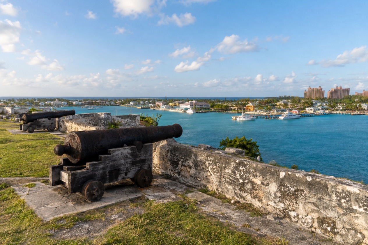
At Fort Charlotte, the stone walls rise from a hilltop just off West Bay Street, and the first thing you notice is how much of Nassau lies spread out below them: the harbour, the rooftops of downtown, the low line of Paradise Island. Cannons point out over the water, and a dry moat circles the ramparts. This is a visit about eighteenth-century defenses, a layered colonial story and a good vantage point over the city.
Is visiting Fort Charlotte worth it?
Yes, for travelers who like history with a view, and especially for anyone curious about how Nassau was defended and who actually lived behind these walls. It suits couples wandering between cruise stops or beach days, and families with children who like cannons, tunnels and a moat.
What sets it apart from other sights in the city is its scale and its layout. Fort Charlotte is the largest of the three forts that remain on New Providence, and it covers a wide hilltop rather than a single tower or a small battery.
It is a complex of three linked parts, with a main fortification, a middle bastion and a western outpost, so you walk from one to the next instead of seeing a single structure. It also sits above the entrance to Nassau Harbour, which means the views are part of the point: you understand why the British chose this spot.
The fort never saw significant battle, and its cannons were never fired in aggression. That gives the visit a calm, almost reflective tone. What you take away is less a tale of sieges than a picture of garrison life, of the soldiers who served here and the community that grew around them.
What to see at Fort Charlotte
The main fort and its moat
The eastern part, called Fort Charlotte itself, was built in 1788 by Lord Dunmore and named for the wife of King George III. It was designed with a drawbridge, a ditch now usually called the moat, a guard room and magazines for powder. You also find an arched bombproof casemate, along with casemates dug into the rock and a furnace once used for heating shot.
Look for the dungeons and the underground passageways, which give the fort its slightly mysterious feel. Stone, shadow and cool air under the ramparts make a contrast with the bright harbor outside.
Fort Stanley and Fort D’Arcy
The middle bastion, Fort Stanley, and the western portion, Fort D’Arcy, were added later. Walking toward them you pass along the line of the hill, with the ramparts opening out to the water. The complex holds 42 cannons in all, set to cover the harbour approaches.
These outer sections are where the sense of scale is strongest. The grounds feel broad and open, and the angle changes at each stretch of wall, so photographs of the harbour, the downtown skyline and Paradise Island all look different from one bastion to the next.
The view over Nassau and Paradise Island
From the ramparts you look over Paradise Island, Nassau and the harbour in one sweep. It is the reward of the climb up the hill, and it explains the fort’s purpose: a lookout above the harbour entrance, with a clear line toward anything approaching by sea.
Take a moment here to trace the harbor with your eye, from the ships at the docks to the bridge-linked island across the water. It is a good place to orient yourself before heading back into town.
The barracks site and the West India Regiments
East of the fort stood the barracks that housed the troops of New Providence. The building no longer exists, but its footprint can still be seen on the ground. European soldiers posted here suffered a very high death rate from yellow fever, which led the British in 1801 to send soldiers of the British West India Regiments to garrison the forts.
Those regiments were commanded by European officers, while the soldiers were African men. After the 1807 abolition of the slave trade, Nassau became a place where Africans freed from illegal slave ships were recruited. Many of the soldiers married Bahamian women and stayed, and they helped shape the Over-the-Hill community even after the British military left in 1891.
Hours, tickets and rules
Admission is modest, with lower rates for seniors and children. Guides on site work for tips and tell the full history of the fort, which adds a lot to a walk through the tunnels and along the walls. On two days a week, a living history scene brings the fort to life.
| Site | Open | Admission |
|---|---|---|
| Fort Charlotte, adults | Living history scene Wednesdays and Fridays from 11:30 a.m., cannon fired at 12:00 noon | $5.00 |
| Fort Charlotte, seniors | Living history scene Wednesdays and Fridays from 11:30 a.m., cannon fired at 12:00 noon | $3.00 |
| Fort Charlotte, children under 12 | Living history scene Wednesdays and Fridays from 11:30 a.m., cannon fired at 12:00 noon | $2.00 |
On Wednesdays and Fridays, characters in period costume demonstrate eighteenth-century life in Nassau, and the scene ends with the firing of the cannon at noon. Guides work for tips.
How to get to Fort Charlotte
Fort Charlotte stands one mile west of downtown Nassau on New Providence, just off West Bay Street. That puts it on the western side of the city center, on a hill above the entrance to the harbour.
Because the fort lies along West Bay Street, you reach it by following that road west out of downtown. The street runs along the shoreline, and the fort rises on the hill beside it, so the direction is simple to follow once you are heading out from the center.
For visitors based on Paradise Island or staying in Nassau, the fort sits on the Nassau side of the harbour. From the ramparts you can see Paradise Island across the water, a good reminder of where you are in relation to your hotel or ship. The location also makes it easy to place within a wider day in the city: it lies west of downtown, so it pairs naturally with the town’s streets and waterfront on the other side of that one mile.
When to visit Fort Charlotte
The best moment is a Wednesday or Friday, when the living history scene starts at 11:30 a.m. and builds to the noon cannon. Costumed characters show how people lived in eighteenth-century Nassau, and the firing of the cannon is the high point. Arriving a little before the start lets you see the whole scene.
On other days the fort is quieter and more contemplative. You can wander the ramparts at your own pace, look into the passageways and let a guide tell the story. The open hilltop means you are exposed to sun, so a morning visit suits those who prefer to walk the walls before midday.
Month by month, the fort works as a visit at any time of year. The Atlantic hurricane season runs from June 1 to November 30, so a trip in those months can bring stormy weather that affects outdoor sightseeing. Outside that window, the open ramparts are a pleasant place for a walk with the harbour below.
Tips for your visit
Bring a camera and something to carry a bit of cash for the entrance fee and for tipping a guide. The guides work for tips and give a complete history, which turns a stroll into a story about Lord Dunmore, the three linked forts and the soldiers who lived here.
Take your time on the ramparts. The harbour, Paradise Island and downtown Nassau all show from different angles, and the moat, the dungeons and the underground passageways reward a slow look. Children tend to enjoy the cannons and the tunnels, and the open grounds give them space to move.
Because the fort lies a mile west of downtown, it combines naturally with time in the center of Nassau. Plan the fort for the living history morning if you can, then head back toward the waterfront for lunch.
Look for the footprint of the old barracks east of the fort. It is easy to miss, but it connects the stonework to the people of the West India Regiments, whose story is the most human part of the site.
Good to know before you go
The U.S. State Department rates the Bahamas Level 2, “Exercise increased caution”, and says most crime occurs in Nassau on New Providence and in Freeport on Grand Bahama.
Bring a little cash for the entrance fee and for tipping your guide. The Atlantic hurricane season runs from June 1 to November 30, so a visit in those months calls for a flexible plan around the weather. As in any busy city, keep a hand on your belongings while you explore the town around the fort.
Sources
- Bahamas Ministry of Tourism, Investments & Aviation (bahamas.com), Fort Charlotte (https://www.bahamas.com/natural-wonders/fort-charlotte), checked October 10, 2026
- Bahamas Ministry of Tourism, Investments & Aviation (bahamas.com), travel blog, Nassau forts (https://www.bahamas.com/blog/historic-forts-of-nassau), checked October 10, 2026
- U.S. Department of State, The Bahamas Travel Advisory, Level 2 (https://travel.state.gov/), checked October 10, 2026
- NOAA National Hurricane Center, Climatology (https://www.nhc.noaa.gov/climo/), checked October 10, 2026
To plan your stay
- Best Time to Visit the Bahamas: Weather, Hurricane Season, Sea Temperatures and Junkanoo
- Where to Stay in the Bahamas: Best Islands, Resorts, Boutique Stays and How to Choose
- Getting Around the Bahamas: Flights, Ferries, Mailboats and Taxis in Nassau
- Know Before You Go to the Bahamas: Entry Rules, Money, Getting Around and Local Customs