
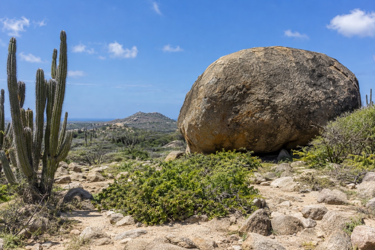
Along the roads of Santa Cruz, the trade wind rattles the leaves of the cacti and brushes over fields of round, rust-colored boulders. Goats pick their way across the rocky ground, and the low houses wear pastel paint that fades pleasantly in the sun.
This is the middle of Aruba, far from the hotel towers, and it is where the island’s landscape and its history are easiest to find. It suits travelers who want to spend part of their vacation looking at rock, desert and old chapels instead of lying on the sand.
Where is Santa Cruz and what is it like?
Santa Cruz is a district in the center of Aruba, with Route 4, one of the island’s main highways, running through it and the eastern half of the island opening out beyond the town. It is a place of countryside and villages, not a resort, and its character comes from what surrounds it: Arikok National Park to the east, boulder fields and hills in every direction, and the quiet of an interior that most beach-focused visitors only cross on the way to somewhere else.
The district also holds a place in the island’s story. Santa Cruz is the birthplace of Gilberto Francois, known as Betico Croes, called the father and liberator of Aruba, and Arubans speak of him with real affection. You do not need a museum to feel that, since the sense of an island with its own identity is strongest away from the tourist strip, in the neighborhoods where Papiamento (the local language, a blend of Portuguese, Spanish, Dutch and African influences) is what you hear in the shops and on the porches.
The pace is slow and the land is dry. The island is small, about 70 square miles in all, and Santa Cruz sits near its heart, so the sea is never far, yet the feeling here is of cunucu, the Aruban word for the countryside. Expect scrub, cactus fences, stone walls and wide skies, with the wind a constant companion on any open ground.
Who will love it? Hikers, photographers, history lovers and anyone who likes to see how a place was shaped before it was a vacation spot. The pleasures here are rock formations, a hill with a view, a small yellow chapel and a long day in a national park. Who may not?
Travelers whose idea of the island is a lounge chair, a cocktail and a view of the water all day. Santa Cruz is a place for days out, not a place that offers a beach in front of your door.
The sea does reach the district, but on its rougher face. Along the eastern edge, the coast is shaped by wind and surf, a different world from the leeward shores on the other side of the island, and that contrast is part of what makes a day here memorable.
What is there to do in Santa Cruz?
The big reasons to come are a national park, a hill to climb and a handful of rock formations and old places of worship that tell you how the island was lived in long before the hotels. What sets Santa Cruz apart from its neighbors is that it is about land and heritage, with nothing built around the beach.
Arikok National Park
The eastern part of Santa Cruz is dominated by Arikok National Park, which covers about 20 percent of the island, and roughly half of it lies within the district. It is a landscape of caves, lava formations, quartz diorite, limestone and Indian rock drawings, with secluded bays such as Moro, Boca Prins and Dos Playa along its coast. Arikok is where you see how dry and rugged the island really is.
One of the best-known stops is the Natural Pool, which locals call Conchi. A barrier of large rocks holds a pool of water apart from the rough sea beyond, and the contrast between the crashing surf and the still water behind the stones makes it a place to stand and look at, with the cliffs and the wind all around you.
A ticket is required to enter, and the small fee supports preservation, education and the park’s animals. Tours led by park rangers are highly recommended for understanding the plants, animals and viewpoints, and a private guided hike lets you explore birds, flowers and geology at your own pace. The park is a good place to spend an entire day, so plan it as the main event of your outing.
Hooiberg, the haystack hill
Hooiberg stands in the middle of the island and rises 540 feet above it, a lone cone that you spot from many points on a drive. Its name is simply the Dutch word for haystack, which is exactly what it looks like from a distance. For a place with no mountains at all, it feels like one.
Hikers climb about 600 steps to the top, and on the way up they may meet wild goats, parakeets and colorful lizards. From the summit the panorama takes in the island’s entire spread, with the towers of the resort coast on one side and the empty hills on the other. Early morning is the kind of hour when the wind is cooler and the light is soft, though the view is rewarding whenever you go up.
Casibari and Ayo, the rock formations
Casibari is a field of giant tonalite boulders scattered across desert terrain, in a residential area just off the main road to Santa Cruz, near Oranjestad. Winding trails run between the rocks, and stairways carved into the stone lead to the top, where a 360-degree view stretches from the coastline to the inland hills. Free Wi-Fi is available at the site, and the BBQ Bar & Grill serves snacks and cold drinks with shaded seating, a welcome pause after the climb.
Ayo Rock Formation Trail offers something deeper. Its tonalite boulders have been rounded and hollowed by weathering into smooth, concave shapes, and they carry indigenous pictographs, the rock drawings of the island’s first people.
Twenty-seven have been documented on a single boulder, out of about 458 across 33 sites on the island. One white pictograph at Ayo has been dated to between 1043 and 1275 A.D. Look up as well, since the warawara, the Northern Crested Caracara, can often be seen perched on top of the largest boulders.
Alto Vista Chapel
Alto Vista Chapel is a small, bright yellow building with wooden shutters, set on a hilltop among cacti and looking over the rugged terrain and the coastline. Its origins go back to 1750, when a Spanish missionary built it, and a tall white cross stands in front of the entrance.
It is a place for a quiet stop, not a long visit. The charm lies in the contrast of the yellow walls against the dry landscape and the wide sea beyond, and in the sense of history in a very small space. Pair it with the rock formations for a day that is about heritage, not about the beach.
How many days do you need in Santa Cruz?
One full day covers the essentials, and two days let you see the district properly without hurrying. Because the island is small and Santa Cruz sits in its center, most travelers fold it into a longer stay on Aruba as a pair of days out, not as a trip of its own.
With a single day, give most of it to Arikok National Park, which is a great place to spend an entire day, and go with a ranger-led tour or a private guided hike if you want the plants, animals and geology explained. If you only have a morning, climb Hooiberg while the air is cooler, then walk among the boulders at Casibari and take lunch at the shaded grill there.
With a second day, slow down. Spend time at the Ayo rock formation, looking for pictographs and the caracaras on the boulders, then visit Alto Vista Chapel for its hilltop view. These stops are all about looking and wandering, so they leave you time to sit in the shade and watch the wind move across the land.
If you have more time, add the beaches and the town life of the island’s other coasts, and let Santa Cruz be the part of your vacation that you remember for its landscape. Oranjestad, the capital, lies near Casibari, so a day that mixes the rocks with a stroll through the city’s colorful streets works naturally. The leeward resort beaches reward a different kind of day entirely, and the contrast between them and the interior is why a longer stay feels richer.
Where to stay in Santa Cruz
The practical answer is to choose a base for the kind of vacation you want, because Santa Cruz works as a day-out district more than as a beach base. Its central position means that wherever you sleep on the island, the park, the hill and the rock formations are within a day’s outing.
Staying in or near Santa Cruz puts you in the heart of the island, close to Route 4 and to the eastern edge where Arikok begins. This suits travelers who care more about early starts on a trail, a quiet evening and a morning in the park than about a sunset on the water. You wake up in the cunucu, among cacti and roosters, and Arikok’s sights are the closest ones.
The other choice is the leeward coast, to the west and southwest, where the resort beaches lie. Palm Beach, the strip of resorts in the Noord district, and Eagle Beach are the names most travelers know. Basing yourself there gives you the sand and the sea at your door, and the interior of the island becomes a day trip that you take when you feel like it.
Oranjestad, the capital, is another reference point. Casibari lies just off the main road to Santa Cruz near the city, which makes the two natural partners on a single outing. San Nicolas, at the other end of the island, belongs to another kind of trip, with its own murals and its own pace.
Whichever area you pick, the wind is the same across the island. Aruba has one climate, so the choice between the interior and the coast is about the kind of day you want to wake up to, not about the weather.
How do you get to Santa Cruz and get around?
You reach Santa Cruz from the airport by road, across an island of just 70 square miles, and the roads are described as safe and modern. Route 4 runs through the district, so the main highway carries you right to it.
A few notes on the airport, since it is where your trip begins and ends. U.S.-bound passengers can access the U.S. Check-In Terminal only up to 3 hours before departure, because of the Gateway 2030 construction. Most shops and food and beverage locations on the right side after security are closed for the preparation of the next phase, so plan to eat before you pass through.
Once on the island, Arubus buses run every 15 minutes from 5:45 a.m. until 6 p.m. After 6 p.m. they run every 40 minutes until 11:30 p.m. That is the frequency for the island’s bus service in general, and it gives a sense of how the day is shaped, with plenty of service by day and a thinner schedule at night.
In this rocky district, the best sights are the ones you reach by car and then explore on foot. Casibari has winding trails and carved stairways, Hooiberg has its steps, Ayo has its trail among the boulders, and Arikok has its own paths and viewpoints. At each one the walking is part of the experience, and the wind makes it feel like open country.
When is the best time to visit Santa Cruz?
The best months for Aruba in general are February through August, and that holds for Santa Cruz, where the pleasure is being outdoors. The peak season runs from December to April, with the off-season from September to November, so the months from May to August give you the island’s sunny days outside the busiest weeks.
Heat is part of every month. January brings afternoons in the mid-80s and nights that stay warm, with rain falling on about ten days, usually in passing showers, and a trade wind that blows steadily from the east.
July is hotter, with highs just above 90, but it has far less rain, around four days, and the wind is a little stronger, which helps on a hilltop or among the boulders. For a day of hiking or climbing, the cooler hours of early morning make the biggest difference in any month.
If you want the island in its liveliest weeks, with the most going on, the peak season from December to April is when many travelers come, and rooms and flights tend to follow holiday patterns. If you prefer quieter roads and trails, the off-season in the autumn months is the calmer choice, and May through August sits between the two, with the island’s sunniest weather and fewer people on the paths.
Good to know before you go
The U.S. State Department rates Aruba Level 1, ‘Exercise normal precautions,’ and says Aruba is generally a safe destination for travelers, with petty crime the main concern in popular tourist areas.
Santa Cruz rewards a slow approach. Greet people with a friendly bon dia (good morning in Papiamento) and take your time, since the district runs at the pace of the countryside.
The wind blows from the east all year, so on exposed ground such as the summit of Hooiberg or the cliffs near the Natural Pool, you feel it constantly. Arikok charges an entrance fee, and the park is best treated as a full day’s outing, ideally with a ranger or a private guide who can bring the landscape to life.
Sources
- Aruba Tourism Authority, Santa Cruz region (https://www.aruba.com/us/our-island/regions/santa-cruz), checked October 9, 2026
- Aruba Tourism Authority, Arikok National Park (https://www.aruba.com/us/explore/arikok-national-park), checked October 9, 2026
- Aruba Tourism Authority, Hooiberg (https://www.aruba.com/us/explore/hooiberg), checked October 9, 2026
- Aruba Tourism Authority, Casibari Rock Formations (https://www.aruba.com/us/explore/casibari-rock-formations), checked October 9, 2026
- Aruba Tourism Authority, Ayo Rock Formation trail (https://www.aruba.com/us/ayo-rock-formation-trail), checked October 9, 2026
- Aruba Tourism Authority, Alto Vista Chapel (https://www.aruba.com/us/explore/alto-vista-chapel), checked October 9, 2026
- Aruba Tourism Authority, Getting around Aruba (https://www.aruba.com/us/plan-your-visit/getting-around-aruba), checked October 9, 2026
- Aruba Tourism Authority, Public transportation (https://www.aruba.com/us/plan-your-visit/getting-around-aruba/public-transportation), checked October 9, 2026
- Aruba Airport Authority, By car (https://www.airportaruba.com/by-car), checked October 9, 2026
- Aruba Tourism Authority, Best time to visit (https://www.aruba.com/us/our-island/one-happy-island/when-is-the-best-time-to-visit-aruba), checked October 9, 2026
- Meteorological Department Aruba (meteo.aw), Summary Climatological Normals 1991-2020, Queen Beatrix Airport station (http://www.meteo.aw/files/Download/climatnormals19912020.pdf), checked October 9, 2026
- U.S. Department of State, Aruba Travel Advisory, Level 1, issued August 19, 2026 (https://travel.state.gov/content/tsg_aem/us/en/home/international-travel/travel-advisories/destination.abw.html), checked October 9, 2026
To plan your stay
- Best Time to Visit Aruba: Weather by Month, Peak Season and Festivals
- Where to Stay in Aruba: Palm Beach, Eagle Beach, Oranjestad and All-Inclusives
- Aruba Airport (AUA): Arrival, Getting to Your Hotel, U.S. Preclearance and Departure
- Know Before You Go to Aruba: Entry Forms, Money, Water and Local Customs