
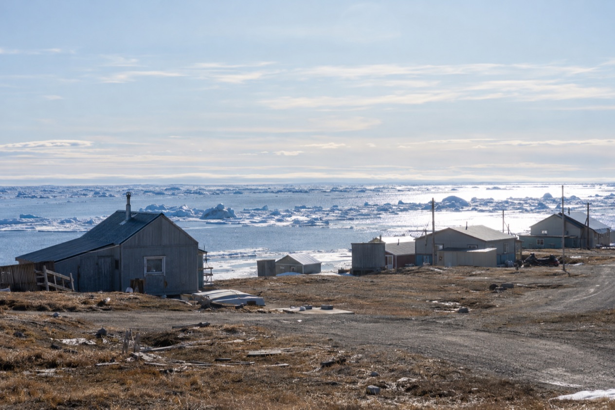
In July, the light over Utqiagvik never goes out. Kids ride bikes along the gravel streets at what a clock calls midnight, the tundra turns green and patchy with wet ground, and the Arctic Ocean lies gray and bright beside the town. This is the northernmost city in the United States, and July is the month when the sun stays up the whole day and the town lives mostly outdoors, for travelers who want the top of the continent in its brightest weeks.
What is the weather like in Utqiagvik in July?
July is cool, damp and bright in Utqiagvik, the warmest month of the Arctic summer but still a sweater-and-jacket month, with the sun above the horizon around the clock.
| Month | Average high (°F) | Average low (°F) | Precipitation (in) | Days with precipitation | Daylight on the 15th |
|---|---|---|---|---|---|
| June | 40.9 | 31.1 | 0.43 | 1.4 | 24 hours |
| July | 47.7 | 35.6 | 0.98 | 3.3 | 24 hours |
| August | 44.5 | 35.1 | 1.09 | 3.8 | 19 hours 4 minutes |
Afternoons reach the upper 40s at best, which feels brisk when the wind comes off the water, and nights hold just above freezing. A dusting of wet snow is possible even now, though it is rare and melts fast.
When a low cloud rolls in from the sea, the horizon disappears and the town takes on a soft, silvery look. Because the ground is flat tundra over frozen soil, wet patches linger in low spots and the unpaved edges of town can turn muddy.
The light is the real feature of the month. The sun circles overhead without setting, so a late dinner, a walk at what would be midnight and an early start are all equally bright. Visitors find sleep the hardest part of the trip, since a room with thin curtains stays as bright as noon.
What to do in Utqiagvik in July
The main thing to do in July is simply to be here under the midnight sun and walk a town that sits on the edge of the Arctic Ocean. With about 5,000 residents, Utqiagvik is the largest U.S. settlement north of the Arctic Circle, and it feels like a real community rather than a sightseeing stop. Most of the pleasure is in looking around: the tundra stretching flat to the horizon, the gravel roads, the whale bones, the boats pulled up on the shore and the seabirds working the coastline.
The town is also the center of Iñupiat life on the North Slope. The Iñupiat have lived on this coast for a very long time, and the rhythm of the year here still follows the hunt, the ice and the seasons.
In July you see this in small ways: boats and gear, drying racks, and the way people greet each other on the road. Be a polite guest, ask before photographing people and their property, and let the town show you its pace.
The midnight sun and the Arctic Ocean shore
Polar day lasts 84 days here, and July sits in the very middle of it. Go out after dinner and the light is still high and flat across the water and the tundra, with the long shadows of an Arctic summer evening and no dusk to hurry you home.
The coast here lies between the Chukchi and Beaufort seas, and the shoreline is a place to walk slowly and look. The water is cold and not for swimming, but the view is the point: drifting ice may still show on the horizon, birds ride the wind, and the sea changes color as clouds move. A windproof layer matters more than the thermometer suggests, because the breeze off the ocean does most of the work.
Tundra, birds and wildlife chances
In July the tundra around town is at its busiest. Low plants and small flowers cover the ground, ponds fill with meltwater and birds that nest on the Arctic plain are active around the wet places. You may see shorebirds, ducks and other nesting species, and with luck a fox or a caribou in the distance, though sightings are chances and never a promise.
Polar bears are part of the larger Arctic story. In the Chukchi and Beaufort seas they are forced onto land in summer when the sea ice disappears, so a bear along this coast is a possibility to respect, not a plan. Follow the safety guidance of local authorities, and if you want a place known for bear viewing, Kaktovik on Barter Island is where visitors go to see them.
Iñupiat culture, language and food
Iñupiaq is still spoken here, though only a small share of the Iñupiat can speak it and most are elderly, which is why language schools such as the immersion school in Kotzebue matter. You will hear it in greetings, see it on signs and learn a few words if you listen. The Iñupiat Heritage Center is the place travelers look to for an introduction to whaling, crafts and the history of the people of the North Slope.
Food is part of the story. Traditional foods such as muktuk (whale skin and blubber) and caribou belong to community meals and celebrations, and a visitor is more likely to meet them as a gift or an invitation than at a restaurant counter. In town, you eat in the handful of local restaurants and cafés, and a hot bowl of soup or a plate of something hearty suits the cool weather after a walk by the water.
Getting a sense of the far North
Utqiagvik is not on the road system. Except for the highway from Fairbanks to Prudhoe Bay, the North Slope is cut off from the rest of Alaska’s roads, and the region depends mostly on waterways and small airports. That isolation is part of the experience: the town feels like an outpost at the end of the map, and its goods and people arrive by air.
Travelers like to reflect on the line between this town and the Arctic Circle, the latitude where the sun does not set at the June solstice. Utqiagvik lies far beyond it, which is why the sun here stays up for weeks and not just a single night. A slow afternoon with a cup of coffee and a window facing the tundra can feel as memorable as any outing.
A two-day itinerary for Utqiagvik in July
Day 1 begins with the town itself. Because the sun never sets, you can start late and still have a full day, so a slow breakfast at a local café is a good opening.
Walk through the streets to get your bearings: the houses on stilts, the boats and gear, the whale bone markers and the edge of town where the tundra begins. Midday suits the Iñupiat Heritage Center, where the history of whaling and Iñupiat life gives context to everything you have just seen.
In the afternoon, go to the ocean shore and walk along the water with a windproof layer on. Stop wherever the view opens up, watch the birds and the light on the water, and look out over the sea. Eat a hearty dinner in town, then come back to the shoreline in the late evening, when the sun is still high and low and gold-tinged and the crowds, such as they are, have gone home.
Day 2 is for the tundra and for the quiet side of the town. Start in the morning with a walk toward the open ground at the edge of town, looking for nesting birds, wildflowers and wet ponds, and keeping an eye out for larger animals at a respectful distance. Take a break for lunch at a café or restaurant, and use the middle of the day for the shops and community spots where local crafts and everyday life are on view.
If the day turns gray and drizzly, spend more time indoors: a longer visit at the Heritage Center, a long lunch, and a slow afternoon watching the weather from a window. When the cloud lifts, finish with one more walk along the shore, since the light after rain is often the best of the trip.
Is Utqiagvik busy in July?
July is the heart of the Arctic summer and the month when the far North is easiest to see, but Utqiagvik is a town of about 5,000 people and never feels like a resort. The pace is set by the community, by flights in and out and by the fishing, hunting and work that fill the long days.
With daylight around the clock, the day does not wind down at an hour you would expect. People are out in the evening, boats come and go, and the streets stay lively well past dinner. For a visitor, that means plenty of room to wander, a sense of a working town and a chance to see everyday life in its summer mode.
What to pack for Utqiagvik in July
The weather is cool and often damp, the wind comes off the ocean and the sun never sets, so the packing list is about layers, light control and boots.
- A warm insulated jacket, because afternoons stay in the 40s and the wind cuts through thin layers.
- A waterproof shell, for the drizzly gray days that come a few times in the month.
- A hat and light gloves, for walks along the water where the breeze is steady.
- Waterproof boots with good grip, since the tundra and the edges of town stay wet and muddy.
- A sleep mask or blackout covering, because the room is as bright at midnight as at noon.
- Binoculars, for birds and distant animals on the tundra and along the coast.
Good to know before you go
Utqiagvik is the northernmost city in the United States and is not connected by road to the rest of Alaska, so the town is reached by air and by water.
Treat the surroundings with care, since this is a living community and its land, boats and gear are not attractions.
Utqiagvik in July vs June and August
Going four weeks earlier brings you to June, which is colder, drier and also bathed in round-the-clock sun. The ground is still thawing, snow lingers a little longer and the tundra is less green, so the landscape feels more wintry. If you like the stark early look of the Arctic spring melt, June gives it to you, with the midnight sun fully in place.
Going four weeks later brings August, a touch cooler in the afternoon and with more rain days. The tundra is at its fullest, but the feeling of endless day is gone, which matters if the midnight sun is your reason to come.
Choose July if you want the warmest weather of the Arctic year together with the sun in the sky at every hour. Shift earlier for a starker, colder landscape, and later if you prefer the return of night and a slightly softer rhythm to the day.
Is July a good time to visit Utqiagvik?
Yes, July is a good time to visit Utqiagvik for travelers who want the Arctic at its brightest and are happy with cool, damp weather and a small town. It suits people who like quiet coastlines, birds, tundra and cultural context, and who do not need a packed schedule of attractions.
It is a poorer fit for anyone who wants warmth, a beach, or a long list of sights and organized outings. Light sleepers should plan for it, and those who dislike wind and gray skies may find the month harder than the numbers suggest.
On arrival, start with a walk through town and out to the water, then spend time at the Iñupiat Heritage Center to understand where you are. Take the evening to stand on the shore while the sun is still high. What makes July here unlike anywhere else in the country is that the sun stays above the horizon through the middle of the night, at the very top of the United States.
Sources
- NOAA NCEI, U.S. Climate Normals 1991-2020, monthly (https://www.ncei.noaa.gov/access/services/data/v1?dataset=normals-monthly-1991-2020&stations=USW00027502), station Barrow Post Rogers Ap, elevation 31 feet, checked October 11, 2026
- Computed from the date and the latitude of the place (sunrise equation, solar elevation -0.833 degrees), October 11, 2026
- Wikipedia, Midnight sun (https://en.wikipedia.org/wiki/Midnight_sun), checked October 11, 2026
- Wikipedia, Alaska North Slope (https://en.wikipedia.org/wiki/Alaska_North_Slope), checked October 11, 2026
- Wikipedia, Inupiat (https://en.wikipedia.org/wiki/Inupiat), checked October 11, 2026
- Wikipedia, Prudhoe Bay, Alaska (https://en.wikipedia.org/wiki/Prudhoe_Bay,_Alaska), checked October 11, 2026
- Wikipedia, Arctic Circle (https://en.wikipedia.org/wiki/Arctic_Circle), checked October 11, 2026
- Wikipedia, Polar bear (https://en.wikipedia.org/wiki/Polar_bear), checked October 11, 2026
- Wikipedia, Climate of Alaska (https://en.wikipedia.org/wiki/Climate_of_Alaska), checked October 11, 2026