
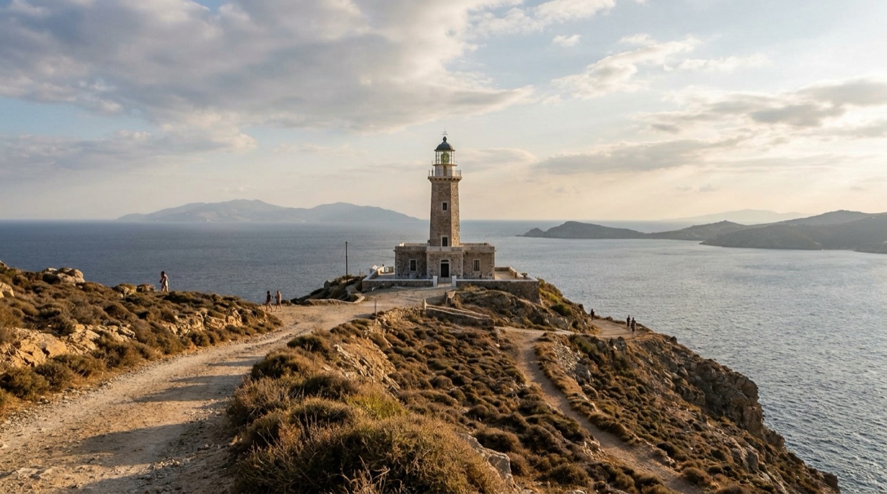
At the far northwest corner of Mykonos, the land runs out at Fanari, and a lighthouse stands where the wind arrives first. The Aegean opens in every direction, the road thins to a ribbon, and the scrub around you is bent by the weather that gave the island its nickname. This is a visit to a headland and a beacon, a place to stand and look out rather than a stop with a program.
Is visiting the Armenistis Lighthouse worth it?
Yes, if you like open horizons, a bit of weather on your face and a different side of Mykonos from the harbor lanes of Chora. The lighthouse sits in Fanari, 4.0 miles from Chora, and that separation from the town is much of the point. You come here to see the island as a piece of rock in a big sea.
Mykonos is known for cosmopolitanism and luxurious vacations, and most of that life plays out around the town and the southern beaches. Here the mood turns. There are no cocktail terraces to organize your visit around, just a working landmark, the sea and the sky. The island is nicknamed the island of the winds, and a headland like this one is where you understand the name.
It is a good counterweight to a week of beaches and dinners. If what you want is a long list of sights and activities, this is a single stop to fit into a wider day, not a destination that fills one by itself.
Compared with the other well-known outing from Mykonos, the tour boats that go regularly to the island of Delos, the lighthouse is a quieter kind of excursion in spirit: no boat to catch, no ruins to decode, only a cape and a beacon that has guided ships past this coast.
What to see at the Armenistis Lighthouse
The lighthouse itself
The lighthouse is the reason for the trip, a tower standing alone on the cape at Fanari. Lighthouses like this one were built to mark dangerous coasts for ships crossing the Aegean, and the northwest tip of an island swept by wind is exactly the kind of place that called for one. From the base you see how small the structure is against the sky, and how much the whole setting is about scale.
Look at the way the tower is placed, at the edge of the land, with nothing between it and the open water. Take in the sound of the wind, which often dominates here, and the shifting color of the sea. Photographers tend to circle the tower to catch it against the sky from different angles.
The headland at Fanari
Fanari means lighthouse in Greek, so the place takes its name from the beacon. The headland around it is rugged, low scrub and rock, with the island rising behind you to a highest point of 1,119 feet. It is a landscape of stone and wind rather than gardens, and it shows Mykonos without its polish.
Stand at the edge of the open ground and look back along the coast, then out to sea. On a clear day the horizon is wide and uninterrupted, and the neighboring Cyclades islands, Tinos, Syros, Paros and Naxos, sit in the same sea around Mykonos. Whether you can spot any of them from the cape depends on the day.
The view over the Aegean
The sea view is the real attraction. The Aegean here is open and often restless, and the lighthouse gives you a fixed point to measure it against. The wind is part of the experience, so expect to hear it as much as see the water.
Visitors simply sit for a while and watch the light change over the water. Bring your attention rather than a plan: this is a place for looking, not for ticking things off.
How to get to the Armenistis Lighthouse
The lighthouse is in Fanari, 4.0 miles from Chora, the main town on the west coast of Mykonos. That distance is the one firm figure for the trip, and it places the cape at the northwest end of the island’s road network away from the town’s lanes.
Travelers reach Mykonos by air or sea. Mykonos Airport lies 2.5 miles southeast of the town, and the flight from Athens takes 25 minutes. Ferries and high speed vessels also visit daily from Athens and from the surrounding islands. From either arrival point, you continue to Chora and then out to Fanari.
The island has three main bus depots. The northern depot serves Ano Mera, Elia and Kalafatis, the old port depot serves Tourlos (New Port) and Agios Stefanos, and the southern depot at Fabrika serves Ornos, Agios Yannis, Plati Gialos, Psarou, Paraga and Paradise Beach. Fanari is not among the destinations named for these depots, so plan your own way out to the cape.
Ano Mera, the only inland settlement on the island, lies about 4.3 miles east of Mykonos Town, which gives a sense of how the island is laid out: a town on the west coast, a village inland and the lighthouse at the far edge.
When to visit the Armenistis Lighthouse
The best time to visit Mykonos runs from mid-May through June and from September through mid-October, while July and August are extremely crowded on the island. For an exposed cape, those shoulder months are the natural fit, with the island at a more relaxed pace.
Rain is rare in summer and returns with the rainy season, which lasts from October until March.
| Month | Average high (°F) | Average low (°F) | Precipitation (in) | Days with rain |
|---|---|---|---|---|
| January | 55.2 | 47.7 | 2.95 | 10.8 |
| April | 64.0 | 54.7 | 0.83 | 3.9 |
| July | 83.3 | 72.7 | 0.02 | 0.1 |
| October | 71.2 | 63.0 | 1.21 | 3.7 |
In July the heat is real and the cape has no shelter in the figures to lean on, so sun protection matters. April and October sit in a middle range, warm enough to be outdoors but with a few rainy days. In January, with many days of rain, a rain jacket and warm layers are the sensible plan. Mykonos is the island of the winds, and that suits a headland visit in any month: expect the breeze to be part of the scene.
Tips for your visit
Bring sun protection in the warm months and a rain jacket if you come between October and March, when the rainy season is on. Sturdy shoes make sense on rugged ground, and a layer for the wind is a reasonable thing to have in your bag.
Chora, with its harbor and town lanes, is 4.0 miles away, and the beaches served by the southern bus depot, such as Paradise Beach and Plati Gialos, offer the contrast in mood. Ano Mera, the island’s only inland settlement, gives another change of scene.
If you plan to visit Delos, the tour boats go regularly from Mykonos, and the lighthouse can sit on another day as a quieter counterpoint. Keeping the two on separate days lets each have its own character, one a site of ruins, the other a cape and a beacon.
Families and travelers who prefer to keep things simple should think of this as a stop for looking and photographing. No facilities, parking, guides or access rules are given for the site, so arrive with what you need and take your time at the edge of the island.
Good to know before you go
Mykonos is nicknamed the island of the winds, so a cape like Fanari is a place where the breeze can be strong, and the sun can be strong too in summer. Carry water and what you need with you, since the cape is far from the town’s shops and cafés. Plan the way back to Chora before you set out.
Sources
- Wikipedia, Mykonos (https://en.wikipedia.org/wiki/Mykonos), checked October 12, 2026
- Visit Greece (GNTO), Mykonos (https://www.visitgreece.gr/islands/cyclades/mykonos/), checked October 12, 2026
- Wikivoyage, Mykonos (https://en.wikivoyage.org/wiki/Mykonos), checked October 12, 2026
- Hellenic National Meteorological Service (HNMS), climatological normals 1991-2020 for Mykonos station (https://www.emy.gr/climatic-data), monthly mean daily maximum and minimum; rain from the ECMWF ERA5 reanalysis, 1991-2020, grid cell of Mykonos (Open-Meteo), checked October 12, 2026
- ECMWF ERA5 reanalysis 1991-2020, grid cell of Mykonos (Open-Meteo), checked October 12, 2026
To plan your stay
- Best Time to Visit Greece: September and Late May to Early June
- Arachova: Parnassus Mountain Town, Formaela Cheese, Ski Season and Saint George's Day
- American Airlines Flights to Greece: U.S. Cities, Athens Arrivals and Onward Island Flights
- Greece on a Budget: Cash Machines, Cards, Beaches and Ferries