
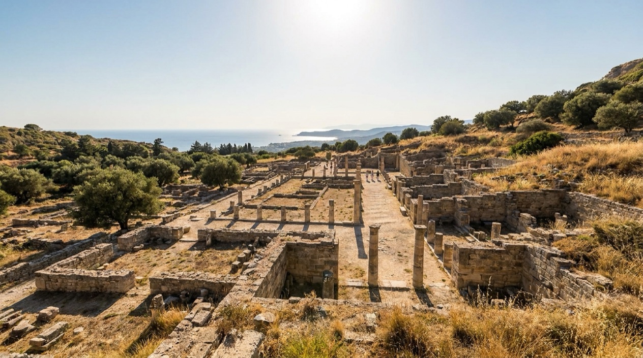
You arrive at Kamiros on the northwest coast of Rhodes, and the first thing you see is not a single monument but a whole hillside of low stone walls, stepped terraces and the bases of columns, laid out like a town that someone simply stopped using. Streets run between the foundations of houses, and a row of Doric columns stands higher up the slope.
Is visiting Ancient Kamiros worth it?
Yes, if you enjoy ancient sites where you can picture daily life, and especially if you want to see what an entire Dorian town looked like instead of one famous temple. Kamiros was founded by the Dorians, and what survives is the plan of a place where people lived: houses, a public square, a water supply and a sanctuary on the high ground.
What sets it apart from the other ancient places of Rhodes is exactly that scale of ordinary life. In the island’s capital, the medieval city, a UNESCO World Heritage Site, is the great draw, and its stones belong to a later age.
At Kamiros the layers are older and the setting is more open, a city on a slope above the coast, 1.9 miles west of the village of Kalavarda. You come away with a feel for how a Greek town was organized: where people drew water, where they shopped, where they worshipped.
Two earthquakes destroyed the city, the first in 226 BC and the second in 142 AD, and the ruins you see are what the ground kept afterward. Later, excavators arrived, first in the nineteenth century and then a large Italian campaign in the twentieth, and their work is the reason the streets can be read today.
It suits history lovers, photographers who like stone against sky, and anyone building a Rhodes trip around more than the old town and the beaches. If you prefer sites with standing temples and tall walls, expect something different here: foundations, bases and a few reconstructed columns, with the rest left to your imagination.
What to see at Ancient Kamiros
The city climbs a slope, so the visit has a natural order from the residential terraces to the public buildings and finally the sanctuary on the acropolis. Look at how each level has its own purpose and how the water, the shops and the temple were arranged to serve a community.
The acropolis and temple foundations
The acropolis is the high ground of the city, and it held the temple, whose foundations were begun at least as early as the eighth century BC. That makes the sanctuary one of the oldest layers of the site. What you see are the footprints of the sacred buildings, with the stone blocks marking where walls and rooms once stood.
This was also the part dug by Alfred Biliotti and Auguste Salzmann between 1859 and 1864. Many of the objects they found left Rhodes and are now in the British Museum in London, so the ground here is an empty frame for pieces that sit in a gallery far away. The earthquake of 226 BC destroyed both the temple and the city.
The covered reservoir
One of the most telling structures at Kamiros is the covered reservoir, built about the sixth century BC. It could hold enough water for up to 400 families, which tells you something no inscription could: this was a planned town that stored its rain and shared it among households.
The reservoir is a practical piece of engineering rather than a monument, and it is the kind of detail that turns a field of walls into a living community.
The stoa and its Doric columns
The stoa was a covered public walkway, and here it consisted of two rows of Doric columns with rooms at the rear that served as shops or lodgings. A few of the columns have been set upright again, and they give the site its most photographed silhouette.
Walk along the line of the columns and imagine merchants, travelers and townspeople moving in the shade of the colonnade. The rooms behind it are the closest thing Kamiros has to a main street of business, and they make the public life of the city easy to picture.
The streets and houses of the lower town
Below the public buildings, the residential quarter is where the site becomes most human. The lower terraces preserve the foundations of the residential quarter. After the earthquake of 142 AD destroyed the city for the second time, this part of the town was left to the weather and the soil.
The Italian Archaeological School began systematic excavation and restoration here in 1928 and kept working until the end of the Second World War. Their clearance of the lanes is why you can follow a street from door to door today. Kamiros was also the home of Peisander, an epic poet of the seventh century BC, a reminder that the people who lived on these terraces made literature as well as pottery.
When to visit Ancient Kamiros
, so the weather shapes the visit more than it does in a museum or a covered monument.
April brings mild afternoons and only a handful of rainy days, a pleasant combination for climbing between the terraces. October is warmer, with highs in the mid-70s, and its rain is modest, although a few wet days do arrive. January is cooler and has the most rain of the four months below, so a rain jacket belongs in the bag, and the stone paths can be damp.
July is the hottest of the months shown, with afternoon highs in the mid-80s and almost no rain. On an exposed archaeological site that means strong sun on pale stone, so sun protection matters more than anything else you pack. The air figures here are those of Rhodes, and they give you a sense of the island’s seasons rather than a forecast for a single hillside.
| Month | Average high (°F) | Average low (°F) | Precipitation (inches) | Days with rain |
|---|---|---|---|---|
| January | 59.4 | 50.9 | 4.19 | 11.8 |
| April | 68.0 | 57.6 | 1.22 | 5.6 |
| July | 86.0 | 75.4 | 0.04 | 0.1 |
| October | 76.1 | 66.6 | 1.85 | 5.0 |
A visit in spring and autumn also fits well into a wider Rhodes trip, because the same mild weather suits the old town of Rhodes and the drive along the island’s western coast.
Tips for your visit
Plan around the weather and the terrain. The ruins extend across a hillside, so plan your visit around the weather. In the warm months the table points to strong sun, so bring a hat, sunscreen and sunglasses, and in winter a rain jacket for the wet days.
Reading about the place before you go adds a great deal. The site has few standing walls, and what makes it vivid is knowing the story: the Dorian founding, the temple on the acropolis, the covered reservoir that served hundreds of families, and the two earthquakes that ended the city twice. With that in your head, a line of stone becomes a street and a square base becomes a room.
What to combine it with on Rhodes
Kamiros sits on the northwest coast, 1.9 miles from the village of Kalavarda, so the surrounding countryside and coastline are part of the day. The village gives you a first taste of the island away from the main town, and the coast itself is the setting from which the ancient city once looked out.
In the city of Rhodes, the medieval town, a UNESCO World Heritage Site, offers a different layer of history, and the harbor there is linked to the story of the Colossus of Rhodes, one of the seven wonders of the ancient world. Seeing both gives you a contrast: a medieval fortress city and a Dorian town that was already in ruins long before.
Following the story beyond the site
Many of the finds from the nineteenth-century excavations are now in the British Museum in London, so if your trip includes that city, you can look for them there and connect them with the acropolis you walked. On Rhodes itself, exploring the island’s capital helps place Kamiros in its wider setting, since Rhodes flourished in the 4th century BC and the island’s cities belonged to the same ancient world.
Food is part of a day like this. On Rhodes you will find tavernas serving grilled fish, salads with feta, and the stuffed vegetables and slow-cooked dishes of the Dodecanese, a pleasant way to end a day among ruins. The island is nicknamed the Emerald Island, and its green hills and coast are the backdrop for the whole outing.
Good to know before you go
Greece uses the euro. Carry sun protection in the warm months and a rain layer in winter, and remember that the ground is uneven and unshaded. The island is large and spread out, so the ruins fit best into a day that also takes in the coast or the main town.
Sources
- Wikipedia, Kamiros (https://en.wikipedia.org/wiki/Kamiros), checked October 12, 2026
- Rhodes official tourism site (https://www.rhodes.gr/), checked October 12, 2026
- Visit Greece (GNTO), Rhodes (https://www.visitgreece.gr/islands/dodecanese/rhodes/), checked October 12, 2026
- Wikipedia, Rhodes (city) (https://en.wikipedia.org/wiki/Rhodes_(city)), checked October 12, 2026
- Hellenic National Meteorological Service (HNMS), climatological normals 1991-2020 for Rhodes station (https://www.emy.gr/climatic-data), monthly mean daily maximum and minimum; rain from the ECMWF ERA5 reanalysis, 1991-2020, grid cell of Rhodes (Open-Meteo), checked October 12, 2026
- ECMWF ERA5 reanalysis 1991-2020, grid cell of Rhodes (Open-Meteo), checked October 12, 2026
To plan your stay
- Best Time to Visit Greece: September and Late May to Early June
- Arachova: Parnassus Mountain Town, Formaela Cheese, Ski Season and Saint George's Day
- American Airlines Flights to Greece: U.S. Cities, Athens Arrivals and Onward Island Flights
- Greece on a Budget: Cash Machines, Cards, Beaches and Ferries