
The road out of Kamari climbs in loops up the flank of a bare limestone hill, and the sea keeps dropping away behind you. At the top, the stones of a classical city lie along the ridge of Mesa Vouno, with the Aegean on both sides. Ancient Thera is the ruined town of the island that was once called Thera, and it is a visit about walking an old street and looking down at the water.
Is visiting Ancient Thera worth it?
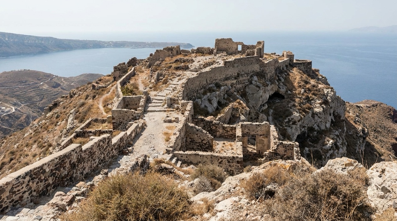
Ancient Thera is the city of classical antiquity that stood on the island now known as Santorini, and its position on top of Mesa Vouno is part of the story.
Santorini has another archaeological site, Akrotiri, and the two are different experiences. Akrotiri is a settlement you visit at its own level. Ancient Thera is a hilltop town that looked out over its two seaports, Oia and Elefsina, which stood at what are today Kamari and Perissa. Walking the ridge, you see the layout of a place that lived by the sea but chose a summit to live on.
The island’s volcano and caldera draw most of the attention on Santorini, and rightly so. This site adds a quieter chapter to the island: the people who lived here in antiquity, how they built their houses around courtyards and cisterns, and where they buried their dead. It is also the place where you understand why the island carried the name Thera long before it was Santorini.
What to see at Ancient Thera
The city grew along one long street, and nearly everything you visit hangs off that spine. The street ran in a southeastern direction and was wide for its time, wide enough that you can picture carts, porters and neighbors passing each other. Following it is the natural way to take in the ruins.
The main street and the Agora
The street is almost 800 m long according to the excavators, and it connects the public spaces of the town. Along it you pass foundations, thresholds and the outlines of buildings, with the slope falling away on either side. Walking it gives a sense of scale that a plan in a museum cannot.
The Agora, the main square, was a long, narrow open space, between 17 and 30 m wide. It is where you imagine the town’s business and gatherings, and from it you can read how the rest of the city was arranged around it. Look for the stone bases and the edges of the paved ground rather than standing walls.
The Basilike Stoa and the theater
The Basilike Stoa was a huge portico, with a roof carried by a row of ten Doric pillars. Even where only the footprint and the bases survive, the long, narrow plan shows how a covered walkway could shelter people beside the square.
The theater dates from the 2nd century and seated about 1,500 people. Its seats face out toward the landscape, so a performance here took place with the island and the sea as a backdrop. Sit on the stone tiers and you see what the audience saw: the open air, the slope, and the water beyond.
Houses, courtyards and cisterns
Most of the inhabitants lived on the mountain plateau in houses built around a small central courtyard, with a cistern beneath it as an essential source of water. On a dry hilltop, that detail explains a great deal about daily life. The courtyards and the cistern mouths are among the small things worth looking for as you walk.
The officers of the fleet lived differently, in peristyle houses with colonnades, mostly built on terraces on the eastern slope below the main street. From those terraces they looked at the sea far below. The terraces give the slope a stepped look that is easy to spot from the street.
The necropolis and the finds
At the foot of the mountain, at the edge of today’s Kamari, lay a necropolis used almost as long as the city existed. Later excavations by N. Zapheiropoulos, between 1961 and 1982, uncovered the city’s necropolis at Sellada. The earlier systematic work, by Friedrich Hiller von Gaertringen from 1895 to 1904, gave the site its first full picture.
Objects from these excavations are on show at the archaeological museum in Fira, which makes a fitting companion to the hilltop: the ruins give you the place, the museum gives you the things people used in it.
Hours, tickets and rules
Ancient Thera is open to the public, and you reach it either by a winding road that starts at Kamari or by several footpaths that climb from both sides of the mountain. That access is the heart of the practical picture: the site is a hilltop, and arriving means ascending Mesa Vouno one way or another.
Once on the ridge, the visit is a walk along the ancient street with the public buildings, the houses and the terraces on either side. The ruins are spread across the hill rather than gathered in one enclosure, so what you see depends on how far along the ridge you go.
For the finds from the excavations, the archaeological museum in Fira is the place where they are exhibited. Together, the hilltop and the museum give both the setting and the objects of the ancient town.
How to get to Ancient Thera
The way in starts at Kamari, a town on the coast of Santorini. From there a winding road climbs the hill to the ancient city. Kamari sits at the foot of the mountain, and it is also where one of the ancient seaports, Oia, once stood, so the old link between the harbor below and the town above is still visible in the landscape.
Walkers have several footpaths to choose from, and they begin on both sides of the mountain. That means the ascent can start from the Kamari side or from the opposite flank, and the route you pick shapes what you see on the way up: the slope, the sea, and the island spread out beneath the ridge.
The other ancient port, Elefsina, stood at present-day Perissa, which lies on the other side of the hill. Knowing that, you can picture the two harbors as the city’s windows on the sea, with the town placed on the summit between them. The hill itself, Mesa Vouno, is a limestone height, which is why the ruins look so carved out of the rock.
Santorini is the southernmost island of the Cyclades, in the Aegean Sea, about 120 miles southeast of the mainland. It is the largest island of the small circular archipelago formed by the caldera. Ancient Thera is one of the places that show the island’s life before the sights that fill most postcards.
When to visit Ancient Thera
The ruins sit on an exposed hilltop, so the season matters for how the walk feels. The air figures for Santorini show a mild winter with frequent rain, a pleasant spring, a hot and almost rainless summer, and a gentle autumn.
| Month | Average high (°F) | Average low (°F) | Rain (inches) | Days with rain |
|---|---|---|---|---|
| January | 57.9 | 49.8 | 2.37 | 10.3 |
| April | 66.0 | 55.9 | 0.63 | 3.6 |
| July | 85.5 | 73.9 | 0.01 | 0.1 |
| October | 73.6 | 63.9 | 0.94 | 3.8 |
July is the hottest of these months, with almost no rain, so sun protection and plenty of water matter on a ridge with little shelter among the ruins. The ancient cisterns under the houses are a reminder of how dry the hill can be.
April and October sit between the extremes, with only a few rainy days each. They are months when a long walk along the ancient street fits the weather. January is the wettest of the four, with rain on about a third of its days, so a rain jacket belongs in the bag and the stones may be wet underfoot.
Tips for your visit
Bring water, sun protection and sturdy shoes, because the site is a hilltop of rock and ancient paving, and the ruins are spread along a long street. In the hottest months, July’s high averages make a hat and sunscreen sensible, and in January a rain jacket makes more sense.
Come with the layout in mind. Follow the main street, stop at the Agora, look for the Basilike Stoa’s row of ten Doric pillar bases, and sit in the theater to take in the view it was built around. Then look for the courtyards and cisterns of the houses, and the terraces where the fleet’s officers lived with their view of the sea.
The site pairs well with the archaeological museum in Fira, where the finds from the excavations are exhibited, and with Akrotiri, the other archaeological site on the island. Seen together, they give two different pictures of life on Santorini. Kamari, at the base of the mountain, is the town where the ancient seaport of Oia once stood and where the necropolis lay at the edge of town.
Good to know before you go
Ancient Thera is a long walk across an open ridge, so treat it as a day of weather as much as of history: the sun in summer, the rain in winter, and the exposed ground all year. Spend a little time at the edge of the ridge looking down at Kamari and Perissa, the two places where the ancient harbors once stood.
Sources
- Wikipedia, Ancient Thera (https://en.wikipedia.org/wiki/Ancient_Thera), checked October 12, 2026
- Santorini official guide (https://www.santorini.gr/), checked October 12, 2026
- Visit Greece (GNTO), Santorini (https://www.visitgreece.gr/islands/cyclades/santorini/), checked October 12, 2026
- Wikipedia, Santorini (https://en.wikipedia.org/wiki/Santorini), checked October 12, 2026
- Hellenic National Meteorological Service (HNMS), climatological normals 1991-2020 for Santorini station (https://www.emy.gr/climatic-data), monthly mean daily maximum and minimum; rain from the ECMWF ERA5 reanalysis, 1991-2020, grid cell of Santorini (Open-Meteo), checked October 12, 2026
- ECMWF ERA5 reanalysis 1991-2020, grid cell of Santorini (Open-Meteo), checked October 12, 2026
To plan your stay
- Best Time to Visit Greece: September and Late May to Early June
- Arachova: Parnassus Mountain Town, Formaela Cheese, Ski Season and Saint George's Day
- American Airlines Flights to Greece: U.S. Cities, Athens Arrivals and Onward Island Flights
- Greece on a Budget: Cash Machines, Cards, Beaches and Ferries